
![]()
Grumpy Old Men's Climbing Club 2025
Griffo | Chris Wales | Adey Cyprus | Adey Picos | Chris Channel Isles | Roy's Trig | Geocrosses | September | October | November | December | Quiz | Craic
- His fingernails, I see they're broken
- His ships, they're all on fire
- The moneylenders lovely little daughter
- She's eaten, eaten with desire.
- Cohen
Click on thumbnails to enlarge.
So, we made it. Breaking all my rules of past years, I stayed up past midnight to watch the London fireworks centred on the London Eye. Wow! Amazing. So here are a few of the pics I took from my television. No, I was not partying on the Embankment.


Strangely, I don't feel that bright this morning, it must have been something in the pigs-in-blankets flavoured crisps at the party last night.
While fine tuning our websites (yawn), I stumbled upon Desert Island Climbs from way back when in 2020. This seems to have slipped through the net. Check out our hopes and dreams (or nightmares) from times past on:
Click to open.
Desert Island  Climbs
Outside it is cold and drizzly. Awesome Walls is cold and finger numbing. It's been like this for several days now and a certain depression is starting to set in. At night, my fevered brain torments me, at the keyboard I compose nonsense. FeverDreams.
Click to enlarge.
The good old days from Brian (Griffo) Griffiths.
1-4


- Mike Richardson, Clive, Al Parker, Mike White, Chris Trotter, March 63
- SUMC, Andy Garvey, Phine, Grochan November 63.
- Paul Nunn on an early ascent of Sir Plum.
- Brian Griffiths, Rod Brown, Motorbike 1965
1-3


- ACG French trip 1975
- Griff, Dave Price, 1962
- Dave Peck, Mike White, Morris Oxide 1965.
Motorbike. Rod Brown and I leaving the Alpha doss on Crookesmoor Rd en-route for Wales.
The “notorious” ACG trip to the Vercor in 1975. Team featured Jack Street, Ken Jones, Al Wright, Speedy Smith, Paul Nunn, Rod Valentine, BG , A.N.Other (can’t remember who). Picture taken outside the Gare du Nord. The GHM (French) ream was headed up by Claude Deck (fair haired guy next to Paul). The trip featured a fracas on the night train from Calais to Paris, impromptu bivouacs, drunkenness (Brits, principally Jack and Ken, sabotaged two of the French team with liberal doses of Talisker. A sanitised version of the trip was published in Rocksport.
Dave Price – Dr Dave of “Double Declutch” (Agden) fame/notoriety when he pulled the finishing hold off and fell the length of the crag. Dave is still climbing, mostly indoors, at Awesome Walls, Stockport.
Finally, the Morris “Oxide” , our alps transportin the summer of ’65. Purchased from Mike White’s Dad for too much money. It broke down in Italy, had to pushed off the autostrada and a repair of sorts was effected with the help of an Italian garage. We with packets of Typhoo tea! It limped home on 3 cylinders and probably ended up in the scrap bay at ESC.
From Tom Westgate

Above is a splendid sunset view of the Salt Cellar from Derwent Edge.
Ski Touring. The video shows Tom in the orange jacket in the hills above Livigno, Italy.
Chris and Sue in Wales, March 7th to 23rd.
Well, we probably can't compete with that, very little snow in Wales and sunsets were thin on the ground. However, we almost didn't get there at all. Sue was suffering with retching and lethargy, and I seemed to have gone down with something bronchial plus a soupçon of lethargy. This plague was almost certainly brought home from the Virgin gym by Sue.
Ever optimistic however, we packed up the camper van and set off, hoping for the best but prepared for the worse. And the best was right, days 1 and 2 were a bit of an effort but after that things steadily improved, and the weather was continuous sunshine for the two weeks that we were away. No rain! What is Wales coming to?
Our first campsite was at the West end of Llyn Tegid, which is the long lake starting at Bala and ending at Llanuwchllyn where our campsite resided next to the railway station at Pandy. The trains wern't running in March and the site was virtually empty. The main objective should have been the Aran ridge but as we were both a bit wobbly we opted for just a bit of it and then a sort of circular ramble to find our way back to the camper. We should have known better, rarely used footpaths drawn on the map with a ruler rarely exist,
1-5


- Pandy railway station
- They're all of a twitter in Llanuwchllyn
- That's our campsite, the Buck rampant.
- Somewhere there is a footpath.
- The farm at the end of the world.
After 5 nights we moved on to the CAM campsite at Gellilydan which, despite the handbook labelling it as Ffestiog it was several miles away. Stlll, there was some excellent walking to be found around this delightful little campsite. North took us cross country onto the track of the Ffestiniog railway as far as Tanygrisiau then back through forestry and little yellow roads, 13 miles. Next day, spurred on by our new-found fitness. we then designed a walk which almost extended us above and beyond the kinaesthetic barrier. The circuit took along the shores of Llyn Trawsfynedd, then over the Cwm of the legendary magic pigs where I always assumed that bogs were more or less horizontal but this 30 degree slope broke all the rules. and then, following a dotted trail on the map which eventually became an actual trail. Eventually we traversed along Llyn Tecwyn Isaf and Uchaf to arrive, gasping at the old Maentwrog power station. Just another 3 miles of steady uphill. 14.5 miles! Ouch!
1-5


- The lonesome farms of the Cwm of the pigs.
- Wobbly walker on a wobbly bridge. Cwm Moch.
- Could this be the next crag X?
- As a member of the peeling paimt society I felt obliged to include this.
- Coltsfoots.
We moved on again, this time to gentle coastline of Anglesey at Coed-Y-Llwyn another CAM campsite. Nice site, the downside was that it was nearly 3 miles from the coast and the bus service was bordering on ficticious.
1-5


- Sue, resting on the waffle grid steps of a stile near Sychnant farm. Here, despite all the signs we took a turn for the worse and had to be redirected by a kind lady farmer on a quad bike.
- Snake's Head Fritillary.
- Cairn-builder-land on the coast of Anglesey
- Red Wharf bay
- While pottering along the coast path near Benlech we bumped into Les and Kerry Nailor whom we hadn't seen since the Parnassus Mountaineering Club 50th anniversary probably 20 years ago. They now live in Llandudno. Small world.
The Hubbards in Cyprus – Feb/March 2025
Why Cyprus at the end of February I hear you ask, as you well might. It has to do with carer cover that fitted around everyone else, it was winter at home and we wanted a break and Jan has a cousin who lives there (who she hadn’t seen for over 50 years) who assured us it would be just fine. So, we flew from Manchester at 14oC. At Paphos airport it was 6oC in the sun!
1-5


Pic 1 is the sunset from our balcony on the first evening. Sadly, Cyprus was having “an unseasonable” cold snap so, at 40C, we did not feel that a G & T out there was really on.Undeterred and wearing our winter woollies, we walked into Paphos port the next morning. Paphos has an ‘old town’ where very little is actually old. The only really old buildings look like modern fakes because they have been restored. In the port area, however, there are many really old parts, from the Greco-Roman period and also from the Byzantine period. Pic 2 is the inside of the Byzantine castle and Pic 3 is the view of Paphos harbour from its battlements. Adjacent to the harbour is the huge Kato Pafos archaeological site with the Tombs of the Kings a short bus ride up the coast. The main site contains about everything you would expect to find in the excavated ruins of the original Greek and then Roman city and much of it is absolutely stunning. Pic 4 shows a small part of the mosaics in the House of Dionysus and Pic 5 a remarkable mosaic that is solid enough to survive the rigours of the “unseasonable weather”. We spent getting on for three hours there because, as well as the extensive historical stuff, it also happens to be on the flightpath of the early migratory birds, of which there were many. Specials were a solitary whimbrel, a couple of bluethroats and a black redstart.
6-10


Up the road, Pic 6 is of one of best of the underground tombs, showing the burial niches in the wall. Pic 7 is from inside the most ornate, thought to have been the burial place of either/both Ptolomy and Cleopatra’s sister.
Filled with actual history, we decided to go for a stroll through Greek myth. On the Akamas Peninsula, which is scenically brilliant, is a round trip taking in Aphrodite’s bathing pool (where she frolicked with Adonis and Akamas), her oak tree (where she rested after bathing - she would have needed to as it’s a lengthy uphill walk from her pond) and the summit of Moutti tis Sotiras. The Rother guidebook suggested 2hrs 30 min for the whole thing. Herr Goetz mut have been running so, thereafter, we added a good 20% onto all of his timings. Pic 8 is Aphrodite’s bathing pool, which did not look at all inviting. Pic 9 is her oak tree, which is also the almost invisible site of a very ancient monastery and the cracking view of the peninsula from the top, Pic 10.
11-17


The peninsula is famous for its Spring flowers, so here are a couple of them. Pic 11 is Asphodelus aestivus and Pic 12 is Bellavalia trifoliata (asparagus family).
The next objective was the Avakas Gorge, a black route in Herr Goetz’s little book, which is sometimes closed due to rockfall or rain, which can fill it up. Undeterred, we drove along the coastal dirt ‘road’ to its mouth by a boulder beach and set off. After half an hour we encountered a sign telling us that the gorge was closed, due to dangerous rockfalls, but people were coming out of it without scars so we continued into it, Pic 13. The gorge is one of only three sites, worldwide, that contain the critically endangered Centaurea akamantis plant Pic 14. Even if it tried it could not be pollinated by specimens from the other two sites (in adjacent gorges) as they are incompatible sub-species. Without its flowers it is pretty underwhelming but was good to find – the label next to it did help a bit. Further in, the gorges narrows and the rock is very unstable, not helped by goats above Pics 15 & Pic 16. The route changes continually because of the rockfall and, in places, Pic 17, is distinctly awkward.
18-21


After a fairly scary hour, however, we emerged unscathed into the lovely upper meadows, Pic 18, which were full of goats. Not fancying Herr Goetz’s suggested circular route, which went for several kilometres through a forest and then three more along the dusty coastal ‘road’, we constructed a much better return through the upper meadows and down to the car. Ralph Goetz (still running) 3hr 30 mins for his longer route; intrepid Hubbards 4 hrs 30 mins for our shorter but much better option.
A trip to the top of the island was called for so we drove up to Troodos. It did not exist before 1924, when the newly installed British Governor of the island decided that Nicosia in the summer was far too hot for governing. So, he built some housing for governing, then some shops (because he realised that the nearest ones were 500m down the mountain on a very twisting road) that he persuaded some of the nearest locals to run and, finally, the church of Saint George (because he concluded that his governing required the assistance of the almighty). Only a British Governor could come up with a plan like that! So, they governed from Nicosia during the winter and from Troodos during the summer. A two-site shifting government base - now where have a come across that idea more recently? Pic 19 is a view of Olympos with snow on the top; enough for some snowmen and a ski club. Downhill for almost an hour brought us to the famous Kykkos Monastery, originally built in the 11th century. I was utterly breathtaking, in a slightly obscene sort of way, when you consider the sheer opulence of the place. Pic 20 is the frescoed entrance and the rest of it is covered in the same manner. Photography is not allowed in the church, which is filled with more frescoes and has a full-width altarpiece of pure gold and silver, from floor to the roof. There are more holy relics there than in the whole of Italy put together, I reckon. Whilst the bits of ‘finger’, the crucifixion cross etc are what they are, and I do respect the right of adherents to believe what they believe, there are other pieces in the museum that are extraordinary. For example, Pic 21 is a copy of most of the four Gospels written in Arabic. The outer pages have been lost, so the first part of one of them and the last part of another are gone but the book is accurately dated to the 4th century, so very early indeed.
22-26


We went back to Troodos for a gentle stroll to the noted viewpoint of Makrya Kontarka, (Pic 23), passing a view across to the abandoned Amiantos asbestos mine, Pic 22, on the way. From here, on a really clear day, you can see two more Greek Cypriot mountain ranges, the Five Finger range in the Turkish north and all the way to the sea at Akrotiri. We couldn’t! On the way back to Pafos we popped into Petra tou Romiou to view Aphodite’s rock, Pic 24. It definitely looks like a head rising from the sea, about to become the lady herself and ready to float to the shore on a bed of flowers. We thought she appeared rather gnarly. What was Adonis thinking?
Our final walk was the Vouni Trail up to Profitis Ilias, here our extra 20% worked out exactly. This leads very steeply uphill for an hour, through terraced vineyards, then across the plateau via a tiny church, Pic 25 and more vineyards, Pic 26, then very steeply down through even more vineyards. The tiny church of Profitis Ilias amply illustrated the gulf between the opulence of Kykkos and the poverty of the little places. We met the local Greek Orthodox priest, at the church, who left his personal vineyard for a chat (probably to make sure we did not desecrate the place). He was very old, with a proper Greek Orthodox beard and a massively extensive knowledge of everything and everywhere around us. Fascinating.
As for Jan’s cousin, the short version is that a quick hospital trip for a very minor procedure turned into a bout of Covid, so we never did meet up. We are going back, next January (when we are assured that it will be fine ……..) for another attempt. Larnaka this time.
Tales of a Troublesome Caravan, Mountains and History by Adey Hubbard
It all seemed so simple. Dronfield to Dover, hop across the channel with Irish Ferries, steady drive down through France and into Spain, a couple of weeks in the Picos de Europa, a week at the seaside and then the Santander to Plymouth ferry home. Our caravan, however, had other ideas.
1-4


All went well to begin with. Arriving in France for an overnight at Eperleques we then took the longish drive down to Tours, mostly in the rain, where we found a lovely site by the River Indre in the town of Montbazon. In the fine art museum, at Tours, were many excellent exhibits including a very fine but distinctly disgusting plate (Pic.1), which would put anyone off their escargots. Suitably educated we went into the old centre of Tours, around Place Plumereau (Pic. 2), where there was a wonderful restaurant serving all manner of stews and cassoulets in a restored 15th Century building – actually in a sizeable bowl in said building - similarly excellent. Even better, the sun came out allowing a bit of relaxation beside the river (Pic 3).
After a couple of days we continued south where we found another brilliant site, 40km inland from Bordeaux and in the middle of a wooded valley with a ruined chateau above, at Rauzan. From here we drove into Bordeaux to find the tram parking, which we didn’t, ultimately ending up in the centre of the city. Just a well we had organised a Crit’Air sticker before we left. We liked Bordeaux for is wide boulevards, spacious squares and fantastic buildings. Lucrative stuff, cognac, obviously. Particularly impressive was the water mirror, in front of the Place de la Bourse (Pic. 4).
5,6


Onwards and southwards we arrived at another site near to Bayonne and Biarritz, which is where the caravan chose to lock its wheels such that it could only move backwards. Sadly, this coincided with the Ascension Day holiday which, being on a Thursday, naturally enabled the French to do ‘le pont’ and carry the vacation right through to the Monday. To fill in the waiting we took a rack railway train up to the top of La Rhune (Pic.5), much cheaper than the Welsh version. We also visited Biarritz (Pic. 6) and Bayonne, which we liked immensely. Our insurance managed to find a couple of caravan “technicians” who came out on the Monday morning, muttered a lot, shook their heads a bit, waved their arms around, jacked up the caravan, hit the wheels with a very large mallet, got them rotating in both directions and pronounced it “Tres bon, Monsieur” and “Un cent cinquante Euros, s’il vous plait”, which we duly paid. Our two-night stop had now taken six nights – “Sacre Bleu!” We hitched up and set off for a pre-booked site near Cangas de Onis, in the western part of the Picos de Europa.
7-10


Cangas opens up access to the western Picos, though the remoteness of the mountains and the absence of roads into them make them long, long days. To get acclimatised, in the rain, we took the funicular from Poncebos up to Bulnes, which takes about 7 minutes. The village (Pic. 7) is utterly rustic and totally traditional. The alternative to the train is a 90-minute walk-in up a very deep gorge with a very steep climb at the end. Until 2001, this was the only way to the village from the main valley road. (Pic. 8). The aim of the whole trip was to get to the bottom of the Naranja de Bulnes, which has been on my “to do some routes on” list for 40 years. I had a plan, to use the 4-wheel drive facility on the car to get to the Collado de Pandebano via a Landrover track. Sadly, heavy rain made this a really bad idea so we opted for a completely different outing, suggested by someone I’ve known for nearly 50 years. “Get the bus from Cangas to the Cavadonga lakes (Pic. 9) and walk to the Avio hut”, he said. “You can’t drive up there after the end of May.” So we got the first bus up, which takes an hour, and began walking. The lakes were fantastic. The walk would have been too, had the extensive rains not created a lot of mud that had been well and truly churned up by vast number of cows on their way to the high pastures a few days earlier. After 3 hours of toil and with the return bus to catch, we gave up at the halfway point and fled (that might not be the best word, as it took almost as long to get down as it had to go up). To regain some composure, we went back the next day to visit the pilgrimage Sanctuary of Our Lady of Cavadonga, which has a basilica and the Lady herself in a cave in a cliff face (Pic. 10). All very atmospheric and very Catholic. Time for something local, we thought, which turned out to be wild boar stew and a Cabrales cheese platter (you think Stilton is a bit strong? Do not attempt Cabrales cheese, which is positively mind-blowing; 90% mould and 10% actual cheese). This was washed down with lots of the local cider. Not quite like our cider, this definitely improves if you pour it out correctly (Pic.11, which is a video clip that I hope you can view). The aeration created completely changes the colour but, most importantly, the flavour. It ish very good indeed.
12-14


Having failed to complete most of our intended targets we moved on to a second site, this time just outside Potes in the Central Picos (Pics 12 & 13). This was a fabulous campsite with very understanding owners. They needed to be as this is where the caravan made its second sabotage attempt. Almost into a very tight pitch the wheels locked again, refused to budge in either direction and sheared the power-mover linkage in the process (Pic 14). Oops!! Undeterred, we rang the insurers again who proceeded to sort everything out, from organising the most technical extraction of a caravan from a pitch that you could possibly imagine (which drew a large, international crowd), to booking us into a bungalow/chalet – Jan called it a shed – on our intended final campsite, right through to setting up the van’s repatriation to where we keep it at home.
15-18


19-21


Whilst all this was going on we drove to the Fuente de cable car and were whisked up to 1,800m, where we found three types of vultures, lots of Alpine Choughs (Pic. 15) and plenty of sunshine at last. There are basically two routes upwards from the top station. The first leads towards the Torre de los Horcados Rojas (2503m), which is just doable in a day, if you get the first cable up (Pic. 16). Sadly, this is not until 10:00am and the last one down is at 6:00pm leaving little margin for error. A good thing to do, after all the earlier failures, but still no nearer to Naranja de Bulnes. Next trip up we went the other way (Pic. 17) and over to the Hotel Aliva, accessible by a long walk or a battered hotel minibus. Whatever, it has no business there in the first place. There followed a long, long drag back up hill, on a small path that sometimes wasn’t really there, minor detours round cows, wild ponies, carpets of flowers and crags to get back to the cable car. The big bonus, and completely unexpected, was a distant view of the Naranja (Pic 18 but you might have to zoom in a bit) poking up beyond a col. Success …. Well, sort of.
Caravan extracted we set off from the shed to our final site at the coast. Another pilgrimage basilica in St. Vicente de la Barquera, complete with medieval bridge (Pic. 19) now somewhat modernised, was followed by a day in Comillas. This was a nice place with the distinction of one of Gaudi’s buildings, before he really got going in Barcelona. El Capricho (Pic. 20) was designed so that, moving from bedroom, to breakfast, then the study, sitting room, dining room and evening room followed the sun, giving light all day.
22-25


Nearby was an extraordinary drive and walk-through zoo park, the Parque de la Naturaleza de Cabárceno, which has massive enclosures and makes somewhere like Whipsnade or Longleat look tiny. In the elephant enclosure (Pic. 21) we counted at least 17 elephants and there must have been well over 25 brown bears in their space, which had grassland, a lake and cliffs. To get round in a day we had to use the cable car, which takes a triangular route of over 2.5km above many of the enclosures. The view from the top was excellent and showed some of the climbing areas within the huge Costa Verde climbing guidebook (Pic. 22).
Going prehistoric we booked for the Altamira cave paintings, in a perfect facsimile construction close by the real thing. If the real paintings inside the real cave are anything like these (Pic. 23), they will be fantastic, Sadly (inevitably), at a maximum of 25 non-research visitors per year, the waiting list for the real version is around 20 years. On the way back to the shed we called into Santillana del Mar (Pic. 24), a well-preserved town of medieval towers, Renaissance palaces and a Romanesque church, funnily enough also on the Santiago di Compostella pilgrimage coastal route. Done with northern Spain, we bid a temporary farewell to our ailing caravan, motionless in its secure compound at Treceno (Pic. 25) and headed for Santander.
Postscript: The caravan arrived home 10 days after we did. Our own caravan technician had it fixed in 15 minutes and we agreed that, if the French had bothered to look underneath, they would have seen what the problem was and mended it properly.
Chris and Sue in the Channel Islands
"So where haven't we been?" she asked.
"ingomells?" I tentatively suggest.
"Perhaps with good reason" came the reply, "but what about the Channel Islands?"
"But I was there only about 70 years ago, but, well, OK"
I turned around and she was already feverishly tapping on the computerr, booking our next getaway with Trailfinders. No way back now.
So, fly from East Midlands, 10 days on Jersey at the rather posh Radisson Blu hotel St. Helier, ferry to Guernsey for another 10 days at the less outrageous Premier Inn in St Peter port, then fly back to Manchester. No available flights to East Midlands but who cares, Sue is paying the taxi man.
It's a short flight from East Midlands airport to Jersey, just over an hour even in our plane which had propellers. We landed at St Helier airport in heavy drizzle which was not quite what we expected, I seemed to remember sun, sun, sun, but surely thingh could only get better? Our hotel, the **** Radisson Blu was a bit on the posh side, and restaurant prices were bordering on scary, with a single course costing well over £35, similar for a bottle of wine that would be £6.95 in Tesco, but the waitresses were very friendly and the rooms were very comfortable though Sue did moan a lot about the lack of a fridge.
St Helier is not the prettiest of towns, being given over to financial institutions and hi-rise residential blocks surrounded by fairly ordinary shopping and restaurant areas.The hotel was very central however and the bus service around the island was second to none, every part was reachable, a hire car would be something of a waste of money. We each bought a 10 day bus pass at £35.

Jersey
This is the most southern of the Channel Islands, and the largest. It's not exactly a desert island however, and is fairly built up by a scattering of rather nice houses over much of the island. There is however a complete coastal path of 50 miles and the excellent bus service means that it can be tackled in sections. The best walking is along the North and Northeast coasts, much of it similar to the SW coast path.
1-4


- 1. The flag of Jersey
- 2. Bording at East Midlands airport
- 3. Elizabeth castle on our first gloomy day.
- 4. Things are looking up, St Catherine's Bay.
5-9


- 5. There are many defensive towers around the Jersey coast. These were built in the 18th century as a defence against France.
- 6. Dolmen du Couperon
- 7. Rozel
- 8. Jersey marina.
- 9. All is not level on the coast path.
10-12


- 10. On the rocky north coast.
- 11. St Helier from Elizabeth castle. The Radisson Blu hotel circled.
- 12. Stand by to repel boarders...
Guernsey
A 50 minute boat trip took us from Jersey to the pleasant little town of St Peter Port on Guernsey. A lot prettier than St Helier though our Premier Inn hotel was about half a mile from the town centre. The hotel proved fine, and beer and food were half the price of that in the Radisson Blu on Jersey.
Like Jersey, Guernsey has a complete coast path, though, being a slightly smaller island it is only 39 miles/ Once again, the excellent bus service allowed any part of the island to be reached by public transport.
The best part of the island for walking was the South and Southeast corner coasts. This was excellent and Sue and I completed it in three very reasonable sections. The paths were good, though signage could have been better. Other parts of the island have extensive beaches and miles of skerries and bottom-ripping rocks far out to sea. We investigated these but the walking proved to rather too flat for us.
The British built 15 Guernsey loophole towers at various points along the coast of Guernsey between August 1778 and March 1779, to deter possible French attacks after France had declared itself an ally of the Americans. Towards the start of the Napolionic wars several towers received additional reinforcement in the form of batteries at their bases. Today, 12 towers still survive, three having been destroyed at different times. Two of the survivors, Petit Bôt and Rousse, contain interpretive exhibits that the public may examine.
1-4


- 1. The flag of the Bailiwick of Guernsey
- 2. St Peter Port and its marina.
- 3. 80th anniversary of the end of WW2.
- 4. Paradise island. Shell beach on the isle of Herm.
5-8


- 5. On the South coast of Guernsey.
- 6. No cars on Sark though there were quite a few tractors.
- 7. La Coupeé links Sark with Little Sark.
- 8. Rescued by the Sark ferry.
9-12


- 9. Petit Bôt bay on the South coast of Guernsey, complete with loophole tower.
- 10. South coast scenery
- 11. Refreshment time.
- 12. Secret bays on the South coast . Spot another loophole tower.
13,14


- 13. Just when you think that it's over..
- 14. Pink Persecaria was everywhere.
Beware of DPFR Race Organisers.
You can’t trust a race organiser, especially their checkpoint descriptions. To illustrate this point, take the recent Crookstone Crashout as an example. The RO, who shall remain anonymous, but was in fact Tom Saville, decided to use a new checkpoint in a location that had not been used by DPFR before. He even published a route map showing the exact location of a small insignificant knoll as checkpoint 3. He must have been ashamed of it’s significance because he embellished it with a trig point on the map. Now I am very gullible so even though I had no knowledge of this trig I decided to check my own maps, of which I have several. Sure enough there was no other map showing this trig. By chance I was going to be out on a walk with Marilyn to look for a swimming hole in Alport River a few days later so we approached from Birchin Clough via said knoll. Suffice it to say we found 1 knoll but 0 trigs. It is however a very nice knoll so well done to Tom for finding it.
An email exchange with Tom evinced the admission that the trig might be transient. This was very good news to all Dark Peakers who have a circuit of the Fifteen Trigs to their name, including Myself and Hugh Cotton (of whom more later). We completed the Fifteen Trigs back in the nineties with only a few minutes to spare on the 12 hour target time. Definitely not enough spare to have included this 16th trig.
I did suspect what was to happen so was looking forward to the race a great deal. These days I have to start races very early to stand a chance of completing before everyone else has gone home. I duly set off at 8:30am, ahead of the early starter at 9:00am and the whippets at 9:30am. It is a great route and on paper looks shorter and faster than it turned out to be. The summit of Alport Castle is memorable for being very slippy in slightly damp conditions. If I am the only person to stand on the very top rock at the summit then I am also both the first and last finisher of the race.
The forest climb out of Alport is one of the main features of the Alport Castles race so will be known to many of you as a complete balls ache and rest assured it is worse than ever. The line over Cowms moor is fairly short to the edge that overlooks Tom’s knoll. Once in sight, the little knoll was sporting a pristine white trig point with DPFR coloured stripes round it’s middle. George Yates was just passing me and reached the trig in time to take the photo you will find on the results page. This might have been a first visit for some but I had visited it a few times before.
In the pub afterwards questions about the origin of the trig were raised and Tom told us that he found in flatpack form in the club hut and had the idea to use as described above.
I had to describe how it came into being originally, which I reproduce here for a wider audience.
1-3


- 1. Roy and Hugh not quite on top of a hill.
- 2. Whole group trying to work out how to get the Trig onto the top of the Tower.
- 3. Is Roy lost again?
The year is 1998 when some of us were in our prime. The above mentioned Hugh Cotton is due to turn fifty in October and being the supreme master of all things celebratory decides to recruit about 50 mates for a coach trip to Paris. Myself, Maurice Musson and Jim Fulton were his closest Dark Peak friends and so got the call. I can’t recall now how the idea came to me but I think I just wanted something of the peak to remind him of home. A few bits of hardboard and dollops of paint and I had a passible albeit slightly small flatpack trig point. It is not full size because I had to get it out of a standard sheet and smuggle it onto the coach as luggage.
Everything went to plan and we had a good night out in Paris, but not so good that I could not re-assemble said trig point outside Hugh’s bedroom door after he was in bed. Quell Surprise
Hugh was suitably surprised next morning and we incorporated the trig into our planned coach trip round the sights of Paris including a photo shoot in front of the Eiffel Tower. The following morning after a very heavy night four of us DPs ran a surprising steep fell race up to the top of Montmartre and back.
So that is the story of the vanishing trig.
It has been used on other races including a Boxing Day Bogtrot and a Burbage Nuts race bur I had not seen it for years and forgotten where it was so well done to Tom for rescuing it.
Roy Small
Check these out. Sue and I had lots of fun with these back in the good old lockdown days. all you need is to have What Three Words (WTW) on your tablet or iphone (as everyone should), and Google Maps. A soucon of skill with map and compass wouldn't go amiss. Once there was only a dozen or so, now there is over 80!
Here's the link.
https://peakdistrictgeocrosstrails.wordpress.com/
Get off your sofa and get out there!
Chris
From John and Valerie Middleton
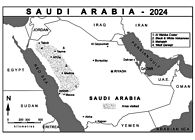
01. THE KINGDOM OF SAUDI ARABIA is a country of over 2,150,000sq.km. Of this, 95% is considered to be desert so why would anyone wish to make a visit? Well, this desert is composed of various volcanic rocks and sandstone bordered by both the Red Sea and Persian Gulf. The result is of a land mass flora extending to over 2,300 distinct species, eighty different mammals, five hundred birds and a considerable number of both amphibians and reptiles. The surrounding seas also possess many of the world’s most pristine coral reefs whilst the land mass itself is magnificently wild and varied - just waiting for exploration!
Whilst the countryside is very dry it is constantly variable with the highest mountain being Jebel Soudah in the south-west which reaches 3,015m. Deep gorges and valleys are a constant feature with highly eroded pinnacles and mounds found between.
Human history extends back to the Mesopotamian people (4,000BCE) but it is really the Nabataeans (100BCE) who left the greatest mark with places such as Petra (Jordan) and Hegra around Alula (Saudi West).
As a Nation the First Saudi State was established in 1744; the Second in 1824; and the current Kingdom of Saudi Arabia in 1932.
Our KINGDOM Explorations! My wife and I, together with our good friend Tony Waltham had wanted to visit the country for three or four years, but access only became possible after the Covid epidemic. Our plan was simply to explore as much of the western side of Saudi as we could in a two-to-three-week period. With the aid of a dependable 4x4 vehicle and reliable driver/guide we successfully managed to do this.
A few of our many highlights are as follows.
2-5


02. JEDDAH. This great city – a UNESCO World Heritage Site - is the principal entry point for visitors to the west. It has managed to retain the old city Centre of Al-Balad where parts can be traced back 1,400 years. Surrounding Al-Balad are buildings of various ages whilst the more modern ones edge the perimeter. This area also hosts the new F1 Grand Prix racecourse.
The nearby city of MECCA is roughly 50km from Jeddah. This is the holiest site in Islam and only Muslims may enter its Centre.
03. DROMEDARIES. These white one humped camels can be seen wandering freely, sometimes as quite large groups. Apart from food they are valued highly for racing.
04. WHABA CRATER. This volcanic crater lies in the Harrat Kishb lava field to the east of Jeddah. It is currently being upgraded into a Tourist Site. It measures almost 2km in diameter and 200m deep. On the bottom a milky lake of sodium phosphate crystals develop whenever there is rain. The walk around the rim is quite sensational with views in all directions and it is possible to reach the bottom via a narrow track.
05. BLACK & WHITE MOUNTAINS. Harrat Khaybar and Harrat Ithnayn are two great lava fields of stunning variation and beauty. The former covers an area of over 14,000sq.km. including the 2,093m high Jabal Abyad.
Caves are a rarity in the country but within Harrat Khaybar there are several small Lava tubes and Umm Jarsen Cave. The latter is found on Jebel Qidr at 1,481m in length and with a main passageway up to 45m wide and 12m high. Various ancient animal remains have been found within. It is also the longest cave yet discovered in the country.
A good 4x4 vehicle is essential for exploration of the region whilst a tented camp exists as a good base.
6-10


06. WHITE MOUNTAINS. Within the Black Mountains there are also several White Mountains which make a unique contrast. The best of these is ‘Al-Ras Al-Abyad’ which is 1,892m high, 1,530m wide and 94m deep. It is possible to walk all the way round the top and descend to its bottom. The whiteness is due to comendite.
07. BURAYKAH ROCKS. Continuing north from Al-ULA towards Tabruk the road travels through an interesting sandy desert. This is spectacularly dotted with impressive pinnacles, rocks and domes.
08. FALCON. The art and sport of Falconry is still practiced and amongst our wanderings we came across several practitioners with their magnificent birds.
09. AL-HAIT ROUNDABOUT. Most road roundabouts at the entrance to towns of all sizes exhibit many local specialties!
10. ELEPHANT ROCK. A very impressive 52m high rock that changes its colour as the sun moves round. It is a popular place with the local people who arrive in the evening and at weekends.
11-15


11. AL-ULA. Situated between a multitude of mighty mountains Al-Ula is really a collection of small villages that make up a historic crossroads for pilgrims and travelers dating back 200,000 years. It is friendly and proves to be an excellent base to explore the region from.
12. HEGRA. Close to Al-Ula is the great Nabataean (mainly) Archaeological Site with 111 amazingly carved tombs of considerable proportions. This was the 1st UNESCO Heritage Site in Saudi Arabia. Due to the fragility of the region these may only be visited in organized groups. These groups are small and well organized.
13. MHAJAAH AREA. Situated north of Route 70 and east of Tayma is a barren land of sand and the best Sandstone Arches in Saudi. Some reach 40m in height.
14. TAYMA HADDAJ WELL. This remarkable well dates to the 6th Century and the Babylonian Empire. Tayma is also endowed with many other historical places including the Al Hambra Archaeological Site, a Museum and a 1,000-year-old Fort. This is considered to be the oldest known inhabited site throughout the Kingdom.
15. WADI DISSA. This great Wadi is situated roughly 225km south of Tabuk and currently requires a 4x4 to reach it. All the effort is well worthwhile as there is a rare green paradise by the track of palms, grasses and small shrubs whilst high cliffs and towers up to 500m high are continually present. With care it is possible to find 3,000-year-old rock art and petroglyphs.
The above includes only a small number of interesting sites but, be assured, there is something to attract your attention around every corner. Help and advice are easy to get as, whilst Arabic is the National language, most people are friendly and speak English. However, it does save a lot of time if a local guide can be used.
Chris and Sue in Scotland. Can't compete with those Middletons.
Off on our holliers again in the campervan on our way to Scotland. Not the usual side, though objectives can vary, but the less explored eastern side for a change.
1-5


01. The remains of Middleham castle
02. Herdwicks, Jacobs, Welsh Blacks, Texels and Orange. These orange sheep are coloured to deter rustlers.
03. Berwick-upon-Tweed.
04. Cormorant family on the Tweed.
05. Eyemouth.
It’s a long way to Scotland, Sue reminded me so we stopped off in the Yorkshire Dales on our way up, at Leyburn in lower Wensleydale which looked a bit flat to me but hey, who knows. We stayed at the CAM for three nights, on one damp day we pottered around the village, day 2 we took off through Middleham to check out the castle, then over the Gallops (it’s very horsey around here) where we just managed to avoid being trampled to death, through West Witton where there is no ice cream shop, over the Ure and home. Ouch, 13 miles.
6-9


06. Burnmouth, between Eyemouth and Berwick
07. Cliffscenery but not for climbing.
08. Tomnaverie stone circle and Sue.
09. Tarland village and scenery.
Onwards and upwards, we stayed at the CAM site at Berwick-upon-Tweed which is not quite in Scotland but very close. Nice city, lots of ancient battlements and things, it also sports 3 bridges over the Tweed. Next day we took the bus the Eyemouth which is in Scotland and walked back along the coast. Lots of cliffs but nothing that looked worth climbing. Exhaustion eventually set in, we’d done nearly 14 miles.
Onwards and upwards again, well sideways actually into Aberdeenshire where we stayed at the CCC site in the slightly obscure village of Tarland. Obscure it might be but it seemed to have vibrant social life, with a cafe, two pubs and various shops and stores.
Tarland also has a rather fine stone circle, Tomnaverie, circa 2000 BC and a remarkable souterraine which we failed to locate. Behind the village is a range of hills which we managed to climb but on descent, we took a turn for the worse and ended up on a mountain bike trail. It all came out in the wash though.
After getting a replacement leisure battery for the campervan, ours had suddenly dropped to 10.5 volts, we moved on to the rather posh little town of Braemar and its somewhat expensive campsite.
10-14


10. Fly agaric funghi were everywhere
11. On the summit of Marrone is a radio transmitter. However, it had little effect on our wireless and TV reception at our campsite which was dire.
12. A view into the Cairngorms from Morrone.
13. Braemar castle
14. Braemar castle.
Towering (?) behind the town is Morrone, a hill that is not quite a Munro. Strong winds and torrential squalls made it feel like one but a good circuit of 9 miles none the less.
So that’s about it, until the next trip that is. We stayed in Braemar for one more day, weather unsettled but we managed to grab a visit to the splendid and dramatic little Braemar castle. An excellent castle with lots to see and some rooms looked as if the residents had just popped out to the shops. Previously owned for a long time by the Clan Farquharson it is now run by the community on a voluntary basis.
Next day we moved on to Stirling which lies on the foothills of the dramatic Ochill hills, but we didn’t go there to gawp at the scenery, we wanted to visit Stirling castle. The bus journey from our campsite at The Woods to Stirling took around an hour overall, just timed nicely for the heavens to open. Great castle though with lots to see there and in the Old Town. Sue, ever the economist asked about our English Heritage membership and got us in for free, saving us £34.
15,16


15. Anyone for tiffin? Braemar castle.
16. A few details of Stirling castle in the pouring rain. Gargoyles and Grotesques.
Onwards and downwards, falling towards England. We stayed overnight at a tiny CS just off the M6, clean and shiney but noisy with nearby traffic. Tomorrow, home and the climbing wall.
When one gets to a certain age, they tell me, you will go on a cruise. They were right, but not lazing around the med on a multi-story cruise liner, but checking out the island studded coastline of Norway on the legendary Hertigruten. Who remembers Slartibartfast? So here we go, a two week trip starting at Oslo and making our was via fjords and towns, across the Arctic circle and all the way to North Cape, the most northerly point of Europe that can be reached by road. Then back, stopping at all the bits we missed on the way up.
1-5


- Leaving Oslo by night.
- Svolvaer, capital of the Lofoten islands
- Svolvaer is surrounded by mountains.
- In the ice museum in Svolvaer.
- In the Hurtigruten museum, which contains the largest single exhibit in the world. A ship.
1-5


- Northern lights 1. Somewhere north of the Arctic circle
- Northern lights 2. We took dozens of these pictures, eventually becoming a bit blase about them.
- Tromsø is on an island, connected to the mainland by this 1.035 km bridge. Spot the Arctic cathedral.
- North Cape, tourists (like us) queueing for their picture.
- That's the trusty Trollfjord, our Hurtigruten.
1-3


- No more special Arctic gin and lingonberries for me.
- Bergen.
- Sue critically examines a work by Irma Salo Jaeger in the art gallery at Andalsnes.
Places visited were:
- Stavanger
- Bergen
- Ålesund
- Åndalsnes
- Alta
- Rorvik
- Kristansand
- Trondheim
- Svolvaer (Lofoten)
- Narvik
- Tromsø
- Honningsvåg ( for North Cape)
but not necessarily in that order.
Back in the old days, Mike Browell was a top athlete and leading marathon runner. (he tells me) So here is something from his archives.
TRIPPING LIGHT - FANTASTIC
Evolution and Revolution
Mountain Marathons are getting harder and I get no younger. As a potential member of Team Lard, I have more need than most of cunning plans when taking part in LAMMs, SLMMs and KIMMs. Running fast is an oft remembered thing, and oft I try to remember.... But seriously, and I do take it seriously, there is still ample scope for machiavellian planning and ruthless trimming.
My game plan is one of absolute but minimal compliance with rules, balanced with a high probability of survival due to plentiful bodily reserves.
As I matured it became a time for innocence, a time for deviousness. No-one could possibly suspect a benign silver-locked post-juvenile delinquent of underhand tactics......
In a time, long ago, there was Pete Livesey’s kit-list, an early type of technology transfer from the cutting edge of climbing ethics to the unsuspecting world of fell running. In that naive world was the starting point of machiavellian planning, a slowly evolving list of weight saving possibilities. Long and hard, so very hard, that list had been analysed and evolved; revised after each mountain marathon, ruthlessly trimming away the excess weight. Evolution is a slow process.......
First came quarter weight karrimat. The square cut corners were trimmed round, the shape cut to a body sized taper and even drilling lightening holes were tested. The most minimal down sleeping bag was begged from the best ultralight manufacturer, having persuaded him against his better judgement to remove most of the down. After researching extreme lightweight silks and searching out an ultra-light 25gm/m2, a sewn silk cocoon shaped liner was made to boost the inadequate insulation properties of the sleeping bag.
Having found the lightest possible gas stove and the smallest gas canister, it was clearly essential to calculate the fuel requirements for one mountain marathon and burn off the excess gas in advance. Cooking had long been discounted and foods were selected which required rehydration only. Water was collected in a wine box foil liner and boiled in a tiny kettle. A single Pot Noodles container later served for soup, custard and coffee.
The tent was a single pole, single skin goretex Phreerunner, the rucksac a KIMM sac.
Spare clothing was a buffalo fleece, a pair of polybags, and lifa tights. A mini Petzl headtorch, mini knife, plastic spoon and small first aid pack completed the kit list. At 4.5kg (10lb) I was delighted and content. I had clearly done all that was necessary to lighten my load.
Oh, complacent fool.
Did I not observe the nominal sacs of elite performers? Were they not little more than bum bags? How did they get away with it?
So many years, so blind, so much to carry, so little used....
Then I was struck by (the need for) lightening!
To cite two Mad Dog Davidson (Team Helium) principals:-
Why carry it if you don’t need it?
Everyone can survive one uncomfortable night.
Evolution is a slow process.......and in the linear progression of time, I had barely reached the Stone Age. What I needed was a jump to hyperspace, to the Age of Enlightenment. It was time for Revolution, not evolution.
In the history of civilisation, all progress is made by the unreasonable man.
Luckily I knew one. When it comes to being unreasonable, there was only one contender. So it fell to Manic Myers to make the breakthrough. With a career break and new employment over the distant horizon he had ample state-sponsored time on his hands. He thought long and hard, he interrogated Rabid Rob (Team Helium) and planned the enlightening....
Away went the karrimat. Quarter weight it may have been but seriously heavy compared to throw-away bubblewrap. This, the ultimate in environmentally friendly materials, already on its second life as a recycled waste, and soon to liberate all those little captive air bubbles, when on Day 2, it goes into the midway camp skip.
Away went the stove and kettle. A tiny aluminium foil dish, drilled with air vents, was enough to hold the solid fuel tablets. Three carefully selected stones from a convenient stream provide a support for the double tin foil pan, recycled from the Chinese take-away. The solid fuel tablets provide a low power heat which gets half a litre of water to boiling in two or three minutes.
Away went the rucksac. Sorry Karrimor, you did all we could expect of a manufacturer whose commercial sense didn’t dare to make a ‘one event disposable’ rucksack. You thought 450gm a small weight to pay for a sturdy durable sac. I now have a 80gm pertex lightweight model that doesn’t have a hood, may not last more than two events without repair, but is so very very light....
Away went the mug (pot noodles container) and torch (bulb, battery, elastic bands and wires). The first aid kit was thinned to a multi functional strip of bandage, elastoplasts and painkillers. The knife became a scalpel blade....
Away went the serious spare clothes, to be replaced with skimpy tights and lifa vest. For one night, damp clothes will dry sufficiently in the sleeping bag.
Away went the sensible tent and in came a very basic Saunders Jetpacker. Then away went most of Saunders more durable design features! The alloy poles were replaced with bendy wood, and if strong winds prevail and break the pole, half a dozen elastic bands work wonders in fabricating a flexible pole from the remnants! On Day 2, the pole goes in the skip. The pegs went, replaced by half length plastic pins. The heavy rubber peg-down loops went, replaced by flimsy elastic ties. The sturdy nylon cord guylines went and fishing line of equal strength replaced them. Replacing the heavy zips with velcro and removing the unnecessary luxury of the mosquito flap on the tent inner doors were next. At least 400gm was shed and more could be achieved by the rabidly ruthless. For summer events where night temperatures of 10 degrees C are expected the inner tent can be dispensed with entirely, getting the entire tent down to 550gm.
And so for SLMM 98, enter the Team Lard lightweight survival sac. At a mere 3.00kg (6.6 lb) on Day One and 2.2kg (4.8 lb) on Day Two it almost matches Team Helium’s best efforts of 1997. But things have moved on. Team Helium have announced the ‘lighter than air’ kitlist. I will have to do some extremely radical pruning.....
Click to enlarge.


 a likely story ...
Mike F Browell
July 1998
From Richard Haszko
MAGIC MOMENTS
‘You set out at the beginning of the day and you just never know what’s going to
happen.’ Valerie’s aphorisms whilst perhaps not possessed of great philosophical
insight do have the undoubted quality of being true. I suppose it’s another way of
saying that the uncertainty of outcome is what gives mountain days their special
flavour. Hill walking does not commonly fall into the category of having
uncertainty of outcome, even in winter: you set off on your walk and there is a
very high probability that you will complete it in good order. However, what can
never be predicted is the sort of day you are going to have. Sometimes it will be
very unpleasant, eyes glued to the ground in persistent cloud and rain. Other days
will be glorious with good company, great views and fine weather. Yet others
will be just so-so. But sometimes, just very occasionally, there will be one that
stands out, one in which something remarkable happens: you will have a Magic
Moment


Mid February in Scotland had proved disappointing in terms of good snow
conditions and weather for some years and this year looked like it wouldn’t be
much different after weeks of mild, wet winds but we went up anyway
encouraged by the forecast of a cold spell in midweek. Somewhat unusually it
looked as if the forecast and weather might actually coincide for one day so we
made plans for a walk in the Mamores. Many of these are very attractive
mountains that happen by the strangest of coincidences, and not remotely of any
significance of course, to be Munroes. We worked out a circular walk starting
from Mamore Lodge above Kinlocheven and Valerie set the alarm for 7.30. I was
a little concerned about this as I have a theory about start times for walks and I’m
sure most people will have experienced the weather changing as the day goes on.
If it starts fine chances are it will turn bad later. On the other hand, if it starts bad
then there is a good chance it will improve. So, if you start early in fine weather
you may well be caught out high on the mountain, get wet or worse, possibly
have to retreat, and almost certainly be down too early to go straight to the pub
for a celebratory/reviving pint. If you start late you will be low enough to change
your plans and do something that doesn’t involve anything character enlarging.
Conversely, a late start on a bad day will have you high up for the improvement.
You will be on top for a splendid sunset while everyone else is well on their way
down and you will have missed the worst of the weather whilst still enjoying a
cup of tea in bed. The odd descent in the dark is but a small price to pay. Opinion
differs on this theory so we compromised and hence found ourselves setting out
from Mamore Lodge at 10.30.


Our first objective, Na Gruagaichen, was drifting in and out of cloud
but we were pleased to see a fair amount of snow high up and it was reassuringly
cold. A small path led off the Land Rover track. ‘Are you sure this is the right
way?’ Valerie enquired. ‘Not completely, no.’ ‘Why not, you read the guide.’ ‘Ah
yes,’ I replied, ‘But you do know my memory is a thing of the past.’ Fortunately
it was the right way and we rejoined the track after 20 minutes or so after a useful
short cut. Discussion of the way on was remarkably short, there being but one
option – straight up the North East Ridge on steep grassy slopes for 1500 ft. It
was a straightforward shut-your-brain-off and plod sort of slope enlivened after
20 minutes or so by passing a man, dog and two boys sitting on some rocks.
Feeling not even slightly competitive we passed them, occasionally turning to
admire the ever-expanding views down Loch Leven until we reached a shoulder
at the foot of a rocky ridge.
Weaving in and out and occasionally over the rocks the ridge
narrowed and became snow covered so it was time to put on crampons. ‘You’re
learning Richard’ Valerie remarked to remind me of several tricky moments in
the past when I had confidently asserted that crampons would not be necessary
and we had nearly died. I had no wish to repeat the frank and open discussions
that that had ensued on these occasions. We were on the summit in a few
minutes, delighting in the frozen snow as cloudbase lifted and the views opened.
After a few minutes view appreciation we turned to look at the way on. The
mountain dropped away remarkably steeply. So steeply we couldn’t actually see a
way on. The guidebook had mentioned a very steep descent but I hadn’t expected
it to be nearly overhanging. Tentatively advancing to the edge of the precipice, I
began to wish I’d put on proper winter footwear instead of seriously bendy
walking boots and old strap-on fully articulated crampons. I teetered down, trying
to find a route that felt less than vertical, thinking how ignominious it would be to
die here. I looked up and shouted to Valerie ‘It’s at times like this I wish I’d
listened to what my father said. ‘Why?’ she replied, ‘What did he say?’ ‘I don’t
know. I didn’t listen.’ Dodging the snowballs she threw at me I carried on down.
It was unnerving, toes at 90 degrees to heels, and I was very glad to get to easy
ground, self-esteem not helped by Valerie who was strolling down confidently
behind me in plastic boots and modern crampons. ‘It’s really quite alright’ I
called up, I was just facing in and going slowly because of the burdens of
leadership.’
We were now on a narrow col with the ridge ahead rising very
steeply. There was with great exposure on one side and a worrying amount on the
other. Valerie set off first, muttering darkly about trying to get her killed and what
made me think I was in her will anyway but it turned out to be much easier than it
looked and provided a fine scramble on snow and rock, soon taking us to the
North West top of Na Gruagaichen. Looking back to the main summit we could
see the other, much younger party reversing their route of ascent. Naturally we
didn’t feel the slightest pleasure that they had opted not to follow us.
We didn’t linger, moving quickly along the level top and down to the
wide col at the head of Coire na Ba. Even though we were now mostly on grass it
didn’t seem worth the effort of removing crampons only to refit them a little
further on but it was definitely time for lunch and obviously not far to the summit
of Stob Coire a’ Chairn so we parked ourselves and had a bite to eat. There was
no-one else in sight. ‘I bet we meet someone on the summit’ Valerie said. ‘It’s
uncanny isn’t it? You can go all day and not see a soul but as soon as you reach
the top you’ll meet someone.’ I had to agree with her, it did seem to happen with
extraordinary frequency. ‘It’s a bit like walking along a road. There can be no
traffic for hours but as soon as one car comes towards you there will be another
coming the opposite way and they will meet exactly where you are so you have to
jump out of the way.’
Finishing our sandwiches and discussion of the peculiarities of life we
set off towards the final slopes of Stob Choire a’ Chairn. It was a broad, easy
ridge and we were soon cramponning up glorious neve.With the clouds dispersing
we reached the summit at a quarter past three. Just at that moment four people
hove into sight, coming up the ridge from Am Bodach. ‘Told you so’ Valerie
murmured as they joined us. They didn’t linger and we soon had it all to
ourselves. The sea glinted in the distance. The massive bulk of Ben Nevis glowed
gold, clear now in the late afternoon sun. The wind dropped to nothing and our
shadows lengthened across the rippled summit snows. A few black-bottomed
clouds floated above us. All around were snow-capped mountains rising out of
darkening valleys. It was completely silent. ‘Richard, it’s one of those magic
moments isn’t it’ Valerie whispered. She was right. It was one of those rare
instances when a day on the hills becomes something very special. We just
looked around, not speaking, feeling very privileged to be in such a place at such
a time. It was a feeling of deep happiness, of a kind that is rare in life but all the
more precious for that. No photograph can do justice to these moments, they have
to be recognised when they happen and locked away in memory to be retrieved
and savoured in the bad times. It was with great reluctance that we turned to go
down, back to that other world.
Richard
From Dave and Linda, November 25.
"Just back from a great trip to Greece, 24 Brexit days mainly climbing.
What!

First week was at Manikia, a new area for us, 2.5 hours north of Athens. Stayed in a little apartment in a hilltop village close to the crags. Had to climb in the shade mainly, and wait for a welcome couple of cloudy days to play on South facing crags.
Then moved via Naphlio and Epidavros to Leonidio where we joined the Castle Mountaineering Club and friends for a couple of weeks. We last went there in 2017, and it has really developed a lot since then. Lots to do, mates to share crags, beers and birthdays.
We were lucky to have a wonderful landlady who cooked for us quite often such delicious Greek food. What a kind thing to do. Our household were so grateful at the end of a good day.
Had a couple of very wet days, needed a rest though! Album cover produced by one of the gang!
We met Dick T , John Jones and pals on the plane home. They were on their way back from Kalymnos. We had hours in the Aegean check in queue together!
Now back home heating on, foggy and wet....".
For us, in Manikia best crags were "All the Universe, fab 40m routes, Bain de Boue, and Rainbow.
In Leonidio, favourite crags include Douvari, Hospital, Dornroschen, Yellow Eyes, and Skiadianiko.


Such a lovely couple!
Well, December the 1st was Marjory Mortimer's 90th birthday. Tony Mays sent me some celebratory pictures so here they are


Cake baked by Messrs Waite & Rose.
Belated Happy Birthday from us all.
Looking foreward to the big 100.
A Grumpy Merry Christmas 


 to all.
So here we are, the 2025 Preposterous Pictorial quiz. for which there will be a presigious bottle shaped prize for the winner.
Please please have a go, don't be coy even if you're struggling to identify even one, you are probably not alone. Email your answers to: chrisandsue59@gmail.com.
Preposterous!
Click on thumbnails to enlarge.

01. Identify that famous pointy mountain (see enlarged) Suilven

02. Identify that Peak District pub Derwentwater Arms, Calver

03. Identify this popular Stanage route. Rugosity Wall, Stanage

04. Identify the Welsh village. Criccieth, North Wales

05. Find the animal hidden therein. MulLION cove, Cornwall

06. Where are we? Patagonia, Torres del Paine

07. Discover the animal hidden here. BakEWEll, Peak District

08. Identify this route. Undecut Crack, Bamford Edge

09. Where is this amazing sincline?. Pembroke. Pen y Holt bay, Range West.

10. Identify this route. Nectre Stanage, fair cop, it's backwards.

11. Where are we?. Dinorwig quarries, Llanberis

12. Identify this crag. Black Rock(s), Cromford.

13. Identify the valley. Abney/Bretton Clough.

14. Where is this stone?. Ringinglow

15. Identify this stone. Oxe Stone(s).

16. Name the famous 19C climber who died on this mountain. O.G.Jones was killed on the Dent Blanche in 1899.

17. Who dat?. Joe Brown, circa 1964

18. Who dat?. Geoffry Winthrop-Young

19. Identify this famous route. The Yellow Edge, Dolomites.

20. Identify this famous boulder. (yes, that's me). The Kjerag Boulder, Norway. 1000m down to Lysefjord.
email to chrisandsue59@gmail.com
Here's this year's group shot. A bit thin on the ground as many Grumpies are away due to sickness/family/climbing/holiday. If anyone would like a higher definition group shop photo just let me know. This on has been dumbed down a bit for the website.

Here are the latest and definitive (I hope) stats for the Preposterous Grumpy Quiz 2025.
Apoplogies for previous incorrect versions due to:
Mike Waters, your answers ended up in my junk folder.
Bill Geary, your answers were lost in a mult-reply email.
- All shall be well,
- And all shall be well
- And all manner of things shall be well.
So said mother Julian of Norwich, a 14th C anchoress.

So, it was a tie break between Adey Hubbard and Mike Waters.
Contestants were assigned bing and bong. First correct answer won the tie break, a wrong answer gave the opposition a win.
Question 1. How old was Don Whillans when he died?
Answer, stony silence, (52)
Question 2. How old was Joe Brown when he died.
Answer, another stoney silince. (89).
Question 3. How old is Chris Jackson on Monday 22nd.
Bong Answered 84, correct!
The winner was declared to be Adey Hubbard (again) winning a bottle of Mouton Cadet Rothschild 95 (or similar from Tesco).
Grump of the Year GOTY. We're all getting too nice! After a bit of a struggtle, Mike Waters and Dave Lockwood were both nominated. After a sea of raised hands however, Dave Lockwood was almost unanimously named GOTY. In absentia, as Dave was not present but we have his trophy ready for him. Grrr!
The Party pics
1-3


- Sandwich time on the back benches. Excellent buffet, as always.
- Deep discussions about the quiz
- Adey Hubbard wins the Chateau Lafite Rothschild 1995 (or similar)
1-3


- After an extended intro, Tony Mays reveals that on a recent trip to Kalymnos, John Jones and Dick turnbull we forced to share a double bed.
- Dick was awarded a tube of lube
- Such a lovely couple.
December 25th Christmas Crack and all that. I was unable to attend this ceremony as I (we) had to be in the metropolis of Clowne by 12 o'clock which made a visit to Stanage a bit impractical. However, Mike Waters came to the rescue and sent in some pictures. Here they are.


Thanks Mike.
So that's it for the year. I stepped back and took a long look through the sweat and tears at all the holiday shots, expedition sagas, disasters, adventures, partying and said to myself
'Is that all there is?'
Is that all there is?
'Is that all there is to a Grumpy website?'
''Cos if that's all there is let's keep on dancing'
'Let's break out the booze and have a ball'
'If that's all'
'There is'