France and Spain 2017

Once again, it's summer holiday time and we point the campervan south. South to Portsmouth this time as we're getting the overnight Brittany ferry to Santander which takes about 24 hours. The Bay of Biscay proved disappointing, flat as a millpond and despite announcements of adverse currents we arrived a mere 30 minutes late. We had booked ourselves into Camping cabo Major which lies just up the coast before we left home and despite the odd glitch finding it, it was an acceptable overnight stop.
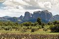
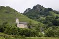
Sue wanted to visit the Costa Daurada and the Costa Brava - a nostalgia trip it turned out and my sister and husband were recommending an outcrop of steep rocks and good walking called El Port or Dels Ports in Catalan, and as it was sort of on the way to the Costas we headed there. It's a long drive from Santander to the village of Arnes on the north edge of El Port and we broke our journey at the slightly weird Ecocamping at Berja. Arnes? Well the nearest town of any size is Tortosa which is some 70km down the coast from Tarragona.
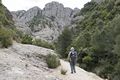
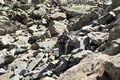
The rock of El Port is conglomerate on the north side, limestone on the south, excellent walking and there was quite a bit of climbing there too. We used the 1:30000 Mapa Excursionista by Piolet along with the Cicerone guide Mountain Walking in Southern Catalunya by Philip and Vivien Freakly, We did several walks from the pleasant campsite at Arnes.
- Roques de Benet, El Port
- Walking in El Port
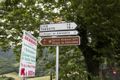
- I think that we're lost
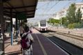
- Train to Tarragona
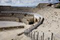
- Roman Amphitheater, Tarragona
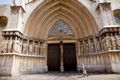
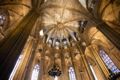
- Tarragona Cathedral
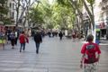
- Ramblas, Barcelona
May 16th We moved to a campsite on the nearby coast called L'Ampolla Playa which gave us easier access to the east side of the range and as it was close to the railway station it allowed us to take the train up the coast to L'Ametlla de Mar and walk back along the coast, and next day, to take the train again to the city of Tarragona which was full of Roman remains. A busy city, fairly interesting but we felt that one visit would last us out.
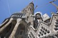
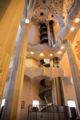
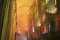
May 19th. After more excellent walking in El Port where we got too hot and took a wrong turn due to somewhat confusing directions we moved again, this time to a campsite north of Barcelona called Camping Barcelona at Matero. This was some 20km up the coast but on the plus side there was a free bus, to and from Barcelona. I'd visited the city whilst on a climbing trip a few years ago but Sue had never been there and was keen to visit, amongst other things Gaudi's La Sagrada Familia. The city was busy despite it only being May and La Sagrada Familia was even busier. We booked online and the campsite printed our tickets for us, and we just walked in at the front of the queue. It's a jaw dropping experience entering this amazing church and even the non-religious cannot fail to be moved by Gaudi's inspiration.
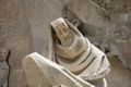
Other parts of Barcelona are also well-worth investigation, there's a magnificent cathedral and things happening at every turn.


- Ramblas, Barcelona
- Barcelona
- Barcelona
- Barcelona Cathedral
- Barcelona
- La Sagrada Familia
- La Sagrada Familia

- Detail, La Sagrada Familia
- La Sagrada Familia, interior
- La Sagrada Familia, interior
- Bikes for hire, Barcelona
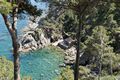
- Costa Brava coastline
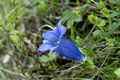
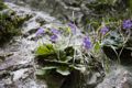
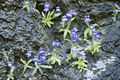
- Trumpet Gentian, Gentiana acaulis
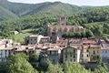
- Prats de Mollo
May 21/22nd. Wonderful city that was, one day of crowds in Barcelona was enough for us and we pressed on towards the Costa Brava and stayed at the pleasant Camping Moby Dick at Calella de Palafrugel where we managed a couple of easy coastal walks and visited the botanical gardens. We also completed a longer circuit to Lafranc and Tamariu where Sue was on a nostalgia trip, reminiscing about her lost teenage years. The coast here was a little more interesting than the Costa Daurada and not quite as developed but it was all getting a bit hot.
May 23rd. Friends recommended the Park Natural de la Zona Volcanica (amongst other places), near the town of Olot. The campsite was OK and was called La Fageda which would seem to have a connection with Beech trees, and there were a lot of them. A pleasant area, slightly boring and reminiscent of an English Beech wood, dotted with the occasional tree filled crater. Not quite what we expected from volcanoes. We moved on, crossed the border with France and joined the eastern end of the Pyrenees at Prats de Mollo where we stayed at the Municipal campsite. OK I suppose but very short on amenities with two toilets, and one shower for the male population of the site. Still, it was a good base and there was a frequent 1€ bus service up the valley which considerably increased the scope of our walks and we managed three long outings using our excellent ffRandonnée French Topo Guides. The town was pleasant with an old fortress that could be accessed by a mysterious souterrain and an ancient church covered in scaffolding.
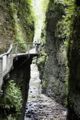
We moved on, calling in at the Gorge du Fou on our way to our next venue Vernet les Bains. The Gorge was spectacular, it's a slot canyon over 200m deep and 1.5 km long and as narrow as 1 metre in places. There were Ramonda plants growing all over, fairly rare but not in this canyon. The campsite recommended by our campsite guide at Casteil was not the least bit tempting and looked unpopular and rather run down so we backtracked a few miles through the town to one that we had spotted on the way in. Camping Del Bosc proved to be perfect for us at €15/night and it was a good job as we were in for a few days of weather, probably due to the influence of nearby Canigou. The campsite was within easy walking distance of the town and during a brief weather window we grabbed our map and scuttled off into the mountains to visit a couple of cascades of which the Cascade des Anglais was the better of the two.
Eventually the weather improved and we managed to complete the Tour de Cogollo, a splendid walk high above the tree line in some unlikely positions. The weather threatened in the afternoon however and twenty minutes from safety (a bar) we got deluged on. Next day we moved on into the more central region of the Pyrenees where it also rained. Pradalongue Camping at Bagnères de Luchon proved a comfortable stop, particularly convenient as it was alongside a supermarket although it was about 2km from the main town. There was a lot of walking to be had around Luchon and we completed two splendid valley walks, one from Valley de Lys to Lac Verte which we had to abandon due to rain and a strange whining noise, and another exploring the torrents of the Cascades de Enfer which, due to past rain were very impressive.
- Fairy Foxgloves, Erinus alpinus
- Gorge du Fou
- Ramonda, Ramonda myconi (R.pyraenaica, Verbascum myconi)
- Cascade des Anglais
- I think that we're lost again, Tour de Cogollo circuit..
- Cascade de Enfer, Bagneres de Luchon
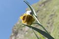
- Asphodel, Asphodelus albus
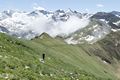
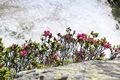
June 7th. The sun is out and we drove up the long zigzags up to the ski resort of Super Bagnères where the mist was clearing and where we planned to climb a small mountain called Pic Céciré 2403m. Our map indicated that we follow the GR10 for most of the ascent but a large sign saying Fermé rather threw us. The GR seemed to have been re-routed by descending to the valley and as that seemed a bad plan we decided to follow the closed path, expecting avalanche or rockslide to have obliterated it somewhere. Not so, but the narrow precipitous path definitely didn't look good for heavily laden GRers. It was excellent for us though, heavy with Alpine flowers and after reaching a cirque below Pic Céciré we could see the new GR10 zigzagging up from the valley. The summit soon arrived though stubborn cloud on the south side obscured views in that direction. Excellent day out.

- Pic céciré
- Mist clearing at Super Bannières
- Pyrenean Snakeshead Fritillary, Fritillaria pyrenaica
- Ascending Pic Céciré
- Large Flowered Butterworts, Pinguicula grandiflora
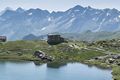
- Refuge Wallon, Pont d'Espagne
- Refuge Wallon, Pont d'Espagne
We moved to Gavarnie and the Pan de Sucre campsite which was a couple of km down the road from the village. Nice spot for €14/night but there was double bad news, the first was that there was to be marathons at Gavarnie over the weekend and it was going to be hell up there, the second was that I had run over our folding table whilst reversing the campervan and it was now, well, a different shape and the crockery was all in pieces. In view of the forthcoming events in Gavarnie we decided to move to the nearby town of Cauterets for a few days where we knew that there was plenty to do. The table? Well I managed to bash it back into a usable shape but we would need to go shopping for plates.
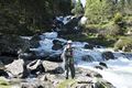
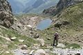
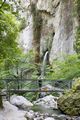
June 9th. Cauterets and the pleasant Cabaliros camping at €15/night. Nearby Cauterets is a reasonably sized town about 1km from the campsite and we were able to stock up on things including plates. Just below the campsite was a small supermarket which was handy but Sue got a bit grumpy as it was quite expensive. Saturday we drove through Cauterets to the popular Pont D'Espagne and walked up the Vallee de Marcadau past impressive waterfalls to the Wallon hut at 1865m. Nice walk and not too challenging. Next day we took a scarily narrow road to hamlet of La Fruitière where we were able to follow a beautiful Lutour valley up to the Lac d'Estrom and the Refuge d'Estom. Scenic but a touch too easy, Six hours including a leisurely lunch by the lake.
Once we had cleared the weekend, we returned to our campsite near Gavarnie.
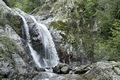
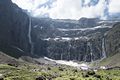
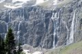
Back in 2009 Sue and I visited Gavarnie and walked the famous traverse in thick cloud and consequently saw nothing. This time the sun was out, the sky was blue and there were magnificent views all-round especially towards the Cirque de Gavarnie which holds Europe's second highest waterfall. The cirque is 800 m wide (on the deepest point) and about 3,000 m wide at the top. The rock walls that surround it can be as high as 1,500 metres (4,900 ft) above the floor of the Cirque. During the warmer seasons of spring and autumn there are a number of large meltwater falls that spill into the cirque. The largest of these is Gavarnie Falls, probably the highest waterfall in Europe though the Austrians maintain that the Krimml falls are higher. It descends some 422 metres (1,385 ft) over a series of steps before reaching the floor of the cirque. The walk follows the limestone balconies on the east side of the valley before dropping down to L'hotellerie du Cirque and the easy return track, about 4 hours.

- Adonis Blue Butterflies, Lysandra bellargus
- Vallée de Lutour near Cauterets
- Alpenrose, Rhododendron ferruginium, Vallée de Lutour
- Long Leaved Butterworts, Pinguicula longifolia
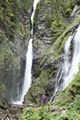
- Waterfalls, Cirque de Gavarnie
- Waterfalls, Cirque de Gavarnie
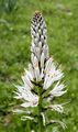
- Garland Flowers, Daphne cneorum
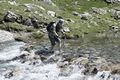
June 14th Almost as impressive as the Cirque de Gavarnie though quite different was the nearby Cirque de Troumousse which we visited from Chapelle de Nèas. Another excellent walk, loads of Alpine flowers and a startling blue lake beneath a cirque of white limestone cliffs. We returned by walking down a narrow toll road, little traffic so it was not unpleasant but with hindsight we perhaps should have retraced our steps. The freezing cold river crossing shown below was not obligatory but it seemed like a good idea at the time. Six hours.

- Crossing the outlet, Cirque de Troumouse
- Cirque de Troumouse
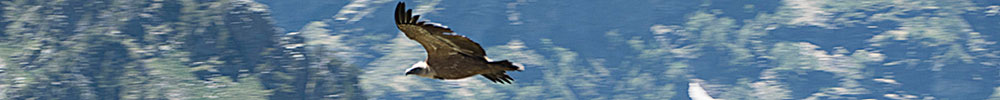
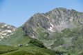
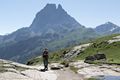
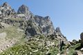
- Pic du Midi d'Ossau
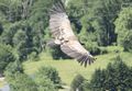
- Griffon Vulture
- Iris, Iris latifolia (I.xiphoides)
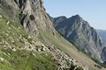
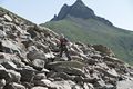
- On the circuit of Pic Du Midi d'Ossau
- Boulders, Pic Du Midi d'Ossau.
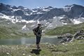
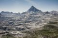
June 15th Friends Sue and Dave had long been waxing lyrical about walking in the Ossau Vallée d'Aspe and although it didn't feature in any of our walking books a visit seemed obligatory. We stayed at the pleasant Camping des Gaves in the small town of Laruns, where we managed to pick up an excellent walking guide book from the tourist office. This was published by the Communauté de Communes de Vallée d'Ossau and described 59 walk from 2 hours to several days and contained proper maps, all in French of course. Our walks of choice were some 30 minutes drive from the campsite to a carpark above Lac de Bious Artigues. From here the jagged peak of Pic Du Midi d'Ossau was readily visible. As a warm up we walked the delightful Tour del Lacs d'Ayous which took us about 6 hours and acted as an intro for our main objective, Le Tour d l'Ossau, graded black, 7 hours and 1255m of ascent. We had a couple of easy days and climbed some grassy hills behind the campsite, then next day started early to avoid the heat for our Tour d l'Ossau.
Brilliant walk, very bouldery in places and with stunning views of the peak. There were climbers in action on it, which appears to have no easy route and also appears to be in a state of falling down. Screes were enormous in places. If you only do one walk in the Ossau valley, and there are lots to go at, this is the one. We just made it in the guidebook time of 7 hours.
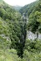
Onwards and westwards to St. Engrace which is in the Basque region near Pierre St. Martin, famous for it's karst and its very deep cave. It is also famous for its slot canyons, The Gorge de Kakouéta, the Gorge de Holzarte and the bridge over Oldhadubi gorge. We stayed at Camping Ibarra near the tiny village of St. Engrace. It was an idyllic little site, no pool, no bouncy castles, just a level site with a fish-filled river alongside.
- Refuge de Pombie, Pic Du Midi d'Ossau
- On the circuit of Pic Du Midi d'Ossau
- On the circuit of Pic Du Midi d'Ossau
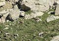
- Izzards (Chamois)
- More boulders
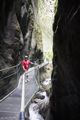
- Gorge de Kakoueta
- Gorge de Kakoueta
The weather became hot, reaching 37C in the afternoons and we were forced to laze around the campsite drinking cold beers. It was hell I tell you. However, we visited the karst, climbed a small mountain called Pic d'Arlas, visited the Kakoueta gorge which was a bit like a big Chee Tor and sneaked into the Pierre St. Martin through the back door via the tunnels dug by EDF in a failed project to tap water from the lowest chamber of the cave. As cave trips go it was fairly inspiring as the first 660m is through very cold and draughty man-made tunnels but the huge chamber that it breaks out into almost makes up for it. La Verna, the company that organises visits operates several different trips, from 1 hour (ours) to 6 hours (wet suits and things) however the longer trips had to be booked well in advance.
La Verna is in the commune of Sainte-Engrâce. 660 metres (2,170 ft) of mined tunnel leads into the Salle de la Verna, the largest chamber in a show cave in the world. It has a diameter of 250 metres (820 ft), a height of 194 metres (636 ft), a surface area of 5 hectares (12 acres) and a volume of 3.6 million cubic metres (130,000,000 cu ft). A river cascades into the chamber from halfway up the east wall, and sinks into boulders near the base of the chamber.
The chamber was named after the Lyon scouts, La Verna Troop, who helped in the attempted rescue of Marcel Loubens who died following a fall during the 1952 explorations. So now you know.
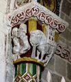
Saint Engrace also has an ancient 11th century chapel which we just had to visit. There were some very strange carvings around the pillars, just what is going on in picture six?
The Holzarte gorge and its bridge were not within reasonable walking distance of St. Engrace so we upped sticks and moved round to the next valley and stayed at Camping Ixtilla near the village of Larrau. The weather was becoming increasingly unstable as we approached the Atlantic end of the Pyrenees but we managed to avoid being deluged though the cloud cover became increasingly low.
25th June, a Sunday and the famous suspension bridge over the Oldhadubi gorge was a popular outing with the locals. However, most of them got no further than the bridge (40 mins) so that the rest of our day was comparatively peaceful. We intended to do a longish walk described in one of our walking guides but part way round we came across a sign pointing to Larrau, our village. Easily swayed we changed tack and followed a lengthy track that barely featured on our map. Fortunately it all worked out fine in the end.


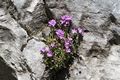
- Rock Jasmine, possibly Ciliate, Androcase villosa
- Pic D'Anie and karst, Pierre St Martin.
- Caving, PSM via La Verna tunnels.
- Where are we?
- Eleventh century Eglise Romane
- Strange inside decoration
- Pont de Holzarte over the Gorge D'Olhadubi
The weather began to deteriorate as we continued west over bright green hills towards our last objective, the Pas de Roland. En-route, Sue wanted to visit the small town of St Jean Pied de Port which was said to be old and pretty, and also on the main pilgrim route to Santiago de Compostela. The town was busy but we just managed to squeeze onto the Municipal campsite which was conveniently close to the town centre. Well, the town was packed with tourist or pilgrims and though it was pretty we felt that 3 hours tramping around the sights was quite enough.
Our last destination before our trip to the ferry port in Santander was Camping Hirriberria at Itxassou near to the town of Cambo les Bains, deep into Basque country. This was an excellent campsite with good facilities but lacking a shop, necessitating a 2km round trip to Itxassou for croissants and baguette. The weather deteriorated but we managed to snatch a short walk to the popular Pas de Roland, narrowly avoiding the afternoon storms.
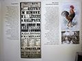
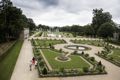
We visited the nearby Arnaga house and gardens, dream home of Edmund Rostand and his son Jean Rostand. Edmund was the auther of Cyrano de Bergerac books and other plays such as Chantecler, a verse play in four acts, notable in that all the characters are farmyard animals including the main protagonist, a chanticler, or rooster. The house, now a museum was a traditional red and white mansion with laid out formal gardens and there was lots of interesting French history inside. We just didn't quite make it back to the car before the afternoon storm.
The weather deteriorated further and we remained virtually camperbound for a couple of days while the rain drummed on the roof. Eventually we gave in, the satnav predicted 4 hours driving to the ferry port so we headed off in torrential rain, and dropped in at the small town of Laredo on the north coast so as to waste a few hours before the ferry. Well, our rough guide was quite positive about Laredo but we found it a little ordinary. There is a large marina and a small old centre but the rest is modern and uninteresting. Sorry Laredians.
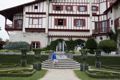
- Arnaga, la demure Basque d'Edmund Rostand
- In the exhibition
- The gardens at Arnaga
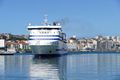
- The good ship Cape Finisterre
Walking Guides:
- Rother Walking Guides, Pyrenees 1,2 and 3. ISBN: 3-7633-4821-2, 3-7633-4826-3, 3-7633-4828-X
- ffRandonée Topo Guide Les Hautes-Pyrénées, ISBN: 978-2-7514-0821-2, www.ffrandonee.fr
- ffRandonée Topo Guide Midi-Pyrénées, ISBN: 978-2-7514-0705-5, www.ffrandonee.fr
- ffRandonée Topo Guide L'Ariège, ISBN: 978-2-7514-0912-7, www.ffrandonee.fr
- 59 Randonées en vallée d'Ossau, www.valleedossau-tourisme.com
- Cicerone guide Mountain Walking in Southern Catalunya,ISBN: 978-1-85284-582-7
- Maps: IGN Cartes de Randonée 1:25000
- EL Port Mapa Excursionista 1:30000, Editorial Piolet
Flower Field Guides
- Collins Mediterranean Wild Flowers, Blamey and Grey-Wilson, ISBN: 0-00-710622-X
- Collins Alpine Flowers, Blamey and Grey-Wilson, ISBN 0-00-219288-8
Costs for period 9th May to 1st July:
- Ferry, Portsmouth - Santander Return: £922
- Campsites: £847
- Fuel: £447
- Motorway Tolls: £190
- Museums etc: £47
- Food and drink similar to UK prices.
Miscellaneous
Trains, sites, caves etc. £245
Vehicle:
- Timberland Destiny automatic on Fiat Ducato 3000
- Fuel 32.5 mpg.
chrisandsue59@gmail.com