Namibia and South Africa 2005
![]()
Words and pictures. A self organised 8 week trip by 4x4 camper around the stunning scenery of Namibia. For our last 3 weeks we crossed the border into South Africa. Places to return to. Non-commercial site with costs and links to other pages.
Click on any image to enlarge. Click to close.
Travelogue of 5 weeks exploring Namibia by 4x4 campervan. Deserts and dunes of every colour, Spitzkoppe, Skeleton coast, Brandberg and the White Lady, Etosha, Sossusvlai and Fish River. Lots of animals, lots of scenery. Words, pictures and costs.
Manchester to Heathrow, Heathrow to Johannesburg, Johannesburg to Windhoek; it seemed a long journey particularly as we had to wait for several hours in Jo'berg for our connection. Much of the flight to Windhoek was above a cloud layer, but shortly before we arrived it cleared and there was an amazing view of endless sand dunes lit by the evening sun. A taste of things to come.
chris and sue jackson e-mail
Windhoek
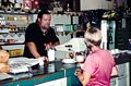
We were picked up at the airport by a man from Asco car hire from whom we were hiring our campervan,and deposited us at their b & b in Windhoek. Nice spot but the razor wire, security gate and armed guard were a bit un-nerving at first but this soon became normal for much of the better property in Namibia. By 11.00 am next morning we had filled in all the relevant paperwork at the Asco depot for our dropping off point in Cape Town, paid our money, been shown round our vehicle, completed a crash 4x4 course in a ravine behind the garage and were on our way. The plan - 5 or so weeks in Namibia, 2 weeks in South Africa. As normal in this part of the world the campervan was a 4x4 pickup, a Nissan in our case with seating for 4 in two roes in the front and a lockable cab on the back. Accommodation was in two tents on the roof which folded out and had ladder access, all the camping gear for 4 was included. First stop was a trip into the town to find a supermarket then back to the b&b to ponder on how to get all the food into the back of the camper along with our luggage - challenging at first though after a few nights we were getting quite slick at it. Windhoek proved to architecturally unremarkable but teeming with life, markets, shops and people wanting to look after your vehicle while you were away. We usually took them up on this offer. We spent another night in Windhoek and can highly recommend the very friendly Delices de France restaurant run by Yann Morizur and his girl friend.
Our first experience of camping in Namibia was at the nearby Daan Viljoen game park quite close to Windhoek. There we learned the secrets of erecting the tents, tables and chairs, cooking with one stove and a braai (barbecue) and fighting off thieving baboons. We also learned that it pays to put on extra clothing before going to bed, the nights here were quite cold.
All seemed to work OK and a packing/unpacking/assemble routine was rapidly developing. Next day we set off on our first experience of Namibian dirt roads. We followed the C28 west, over the Bosua Pass which turned out to be one of the rougher roads of our holiday. Most of our time on this type of road we kept the camper in 4X4 with the front hubs locked. We also learned about dust which plumed out from the back of the camper, got through every nook and cranny and required us to tie poly bags over the rear locks and gas cylinders to prevent them becoming clogged.
The desert landscape was wonderful and soon after leaving the suburbs of Windhoek we entered a huge landscape of rolling brown hills and thorn trees like something from a film set. We stopped overnight at a small campground at the very pleasant and friendly Tsaobis Leopard sanctuary where we got to stroke leopards.
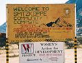
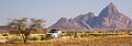
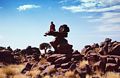
Our first major objective was the Spitzkoppe, a rugged pile of rocks that turned out to be a small mountain, jutting some 500m or more out of the plain north of the town of Karibib. This was a fabulous place though the camping was fairly primitive, well, just a braai pit actually. The rock was an excellent red granite and despite the temperature approaching 40C there were a couple of rock climbing teams in action.
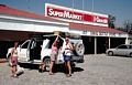
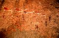
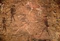
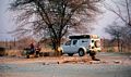
Above, shopping in Windhoek, entrance to the Spitzkoppe campsite, Leopard in the rescued leopard reserve, The Spitzkoppe, us hiding in the shade of a large boulder with temperatures hovering in the upper 30C. L - R Suzy, Mal, Bob, right, going for a walk. To the east of the Spitzkoppe was another ridge of steep granite called The Pondok which looked to have excellent potential for a tricky ridge traverse. Here we explored the Bushman's Paradise, a secret garden of rock art and prickly bushes accessed by steps and a cable.
Next day we moved out to the coast where we swapped 40C sunshine for 15C, a grey sky and a hint of drizzle due to the cold Benguela sea current that originates somewhere near Antarctica. The landscape became utterly barren without a speck of green anywhere as we arrived at Swakopmund, a typical medium sized Namibian town with straight streets, low rise buildings and a lot of unemployment though it tries hard to be a holiday resort and fishing centre. As always in the towns it was necessary to keep an eye on the vehicle or pay a 'guard' a few N$ to do so. Here we obtained fuel and groceries. The private campsite Alte Brukke close to the sea front was excellent and each stand had its own (warm) bathroom which was very welcome. The weather remained grey and cool and we drove down to Walvis Bay where there are extensive salt pans and lots of Flamingoes and other birds. From here we drove inland and although it became a lot warmer it was no less barren save for the remarkable Welwitschia mirabilis which exist only on the gravel plains of the northern Namib desert. Despite their disheveled appearance these plants have only two leaves, are bisexual bearing small cones and can live up to 2000 years. Almost obligatory is an ascent of the nearby 70m Dune 7 where the locals practice their sand boarding.
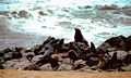
Back on the road again we drove north along the salt road through the National West Coast Tourist area to the Skeleton Coast, both desolate areas though the ever changing colours of the rocks and the sand more than made up for the lack of green and the cool grey climate. At Cape Cross we visited the very smelly Cape Seal Reserve (above)where it was possible to get very close to them. There were literally thousands of them spread out along the coast.
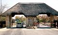
We entered the Skeleton Coast National Park at Ugabmund at the mouth of the Ugab river (or what remains of it) where money changed hands. Continuing north the road began to deteriorate; it became more narrow and with drifting white sand blowing across it became almost hypnotic. We were quite glad of our 4 wheel drive, tyre tracks from a 2 wheel drive vehicle somewhere in front suggested that the driver was having some difficulties.
After a further desolate 110 km just short of Torra Bay we turned inland on the C39 as further progress along the coast line required special permission. The temperature rose rapidly as we left the cloudy coast and by the time we crossed the dry bed of the Huab river it was well into the 30C. That night we stopped at Camp Xaragu an excellent though not cheap campsite where we spent a couple of days due to me going down with something horrible and where I had to be transferred to a chalet with en suite facilities. Enough said!
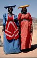
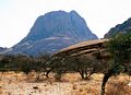
Still a little light headed we loaded up the camper and headed for the town of Uis and the Brandberg mountains. On route we couldn't resist stopping at a roadside stall selling traditional dolls, attracted by two delightful Herero women attired in traditional dress. The Herero people originally came from Kaokoland near the Kunene river but over the last 150 years have migrated south. Traditionally they were pastoral people. We couldn't resist the dolls, such detail and asking so little for them.Brandberg, another granite mountain of 2573m, higher than the Spitzkoppe but more sprawling and less pointed. Here we came to see the famous White Lady of Brandberg, an enigmatic cave drawing some 45 minutes hot walk into the hills along the Tsisab ravine. The figure is painted white, is clutching what looks like a wine glass and is definitely not a lady. Currently undated but thought to be some 16000 years old. The figure has been adopted to adorn the bottles of a certain South African wine.
Etosha.
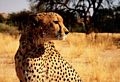
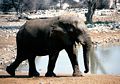
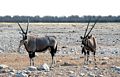
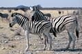
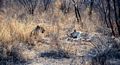
This seems to be where everyone heads to when they visit Namibia. Most activity was around the water holes in the evening though wild life could be seen at almost any time of day. Over 2 days we saw Elephant, White Rhino, Warthogs, Giraffes, Blue Wildebeest, Springbok, Steenbok, Kudu, Gemsbok, Lions, Burchell's Zebra, Cape Vultures, Secretary birds, Great Bustards, Ostrich, the list goes on. Above 3, Kudu and Springbok. The campsite at Halali had a water hole quite close by and it was easy to wander there in the evening.
Etosha was a hot and desolate place, flat with mixed scrub and a barren area of salt pan that is just dazzling white as far as the eye can see. It was also an expensive place with unimpressive facilities for camping and officials often seemed sullen and disinterested. The campsite at Okaukuejo (top) consisted of a dust bowl with the occasional acacia tree for shade in temperatures of 40C, few power points all booked up; water and old overused toilets 100m away. The facilities at Halali were somewhat better, there was some shade and a nearby pool.
However,above, entrance, campground, Elephants, Gemsbok, Burchell's Zebra, salt pan, lions.
From Etosha we turned south and headed for small park of Waterberg which consisted of high plateau surrounded by a sandstone escarpment. It was a pleasant park but walking was limited as day hikers were not allowed onto the plateau.
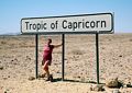
South again, back through Windhoek where we stocked up on everything, back to Daan Viljoen park where we again froze overnight and were ripped off by baboons, then south again down the C26 into new territory. Brown stoney desert soon became sandy and the skyline to the west was soon lined with pink and yellow dunes. At the Gaub Pass we crossed the tropic of Capricorn (left) arriving at the collection of shacks known as Solitaire. Here there was a store, a petrol station and a cafe where they served what was probably the best apple crumble in Namibia and where Sue bought a bottle of gin despite being warned by the retailer that it could stunt her growth.
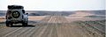
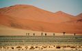
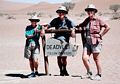
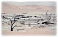
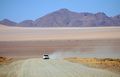
South again with the dunes growing ever closer to Sesriem at the entrance to the Namib Naukluft Park and the next tourist trap, the dunes of Sossusvlei. This was a strange place with a part surfaced road, sometimes covered with deep sand, boring 65km deep into the dunes (see top right). The dunes tower up to 200m above the road, and occasionally (1997, 2001) the Tsauchab river gathers enough water to reach the ephemeral pan at Sossusvlei where it sinks beneath the sand. On these occasions the pans become blue-green lakes and flowers bloom and animal and bird life appears as if by magic. No such luck when we visited. The last few km requires 4x4 some 4X4 skill with driving in deep sand. Last picture, Dead Vlei, one of the salt pans some 1.1km from the road.
Onwards and downwards. From Sesriem we followed the C27 past the settlement of Betta to stay overnight at a campsite by Duwisib castle, a bizarre edifice in the middle of the desert built in 1909 for Baron Captain Hans-Heinrich von Wolf for his wife Jayta Humphries. Built in red sandstone I thought it looked more like a mausoleum. Check this one out, it's an interesting story.
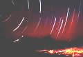
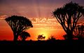
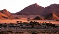
The more we progressed south the more the colours and textures of the scenery grew. We left the C27 to follow the minor D707 which wound its way around the west side of the Tirasberge (picture 1) and it seemed that every bend and viewpoint presented a view more magnificent than the last. Grey and blue mountains, black rock draped in white quartzite sand dunes of red and purple that stretched 100km to the coast and plains of sparse yellow grass. Stunning, we just couldn't get enough, 2, a time exposure from a lonely campsite and 3, Quiver trees at Kokerbooms NP.
Too soon it seemed we arrived at the C13 and then the metalled B4 leading to Luderitz. We stayed overnight in the campsite just outside Aus, a pleasant desert spot with lots of interesting rocky excrescences and trails. The road from Aus to Luderitz is 125km and is surface though the last 10 km are often blocked by the unstoppable march of the dune fields. A new railway seemed to be being built when we were there, we wished them luck, the old line had been completely inundated. South, were the restricted diamond fields.
Luderitz is a bit of a bizarre place. It's in the middle of nowhere surrounded by an utterly barren landscape. It is also up against the restricted diamond area and much of its history and that of the deserted village of Kolmanskop is tied up with the diamond trade. It has a rather Germanic air and indeed, Kaffee and Kuchen are readily available. We rented a self catering apartment for a few days - luxury; found the laundrette, stocked up on gin, beer and groceries, explored the peninsula and took a boat trip for a few hours to view the penguins and whales. Penguins yes, whales no.
Keetmanshoop and the Quiver Tree Park. Back to Aus and then continuing east for several hours we came to the town of Keetmanshoop. A good watering and shopping centre , the town was not an objective as such, it was just on the way to the Quiver Tree park. These trees (Aloe dichotoma) grow all over Namibia and are also known as Kokerbooms. They seem to like dry rocky terrain and the park had a fine concentration of them. When dry, the branches were hollowed out by the San people to make quivers. Right,, Kokerbooms at sunset.
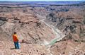
Our last objective before the South African border was the Fish River Canyon. (left). From Keetmanshoop we took the scenic D608 which wound and undulated its way through the Klein Karasberge to join the C12 and then the C37 to the campsite and park entrance to Fish River Canyon. It's a popular stop with tour groups and in the evening the site filled up with huge tour buses full of Germans and South Africans. The campsite was pleasant though the facilities seemed far too small for the demand and the baboons were something of a nuisance. Despite stacking our plastic boxes with click-on lids and then heaping a bench on top of the lot we came back to find them all on their sides with the tops off and things missing. Grr, I hope they get indigestion!
We checked out the village of Ai-Ais at the bottom of the canyon, there were thermal baths here and a pleasant looking campsite. From there we headed south to the Orange River (right) and the border with South Africa at Noordoewer where we all silently prayed that our papers were in order.
Security in Namibia
Before we started this holiday we were understandably a little nervous about personal security in Namibia. On reflection, I have to say that we never once felt threatened and most of the time the local people were extremely helpful and friendly. Common sense should prevail however; there is much unemployment in Namibia and as in many places in the world, including parts of the UK one should not leave a car or camper loaded with food and equipment unattended. Do not wander through towns away from the tourist path displaying obvious wealth such as cameras and expensive clothing. On shopping trips we almost always left someone in the vehicle whilst the others went shopping. In the towns we were often approached by people wanting to look after our carfor a small charge while we were away. Our limited experience of this kind of offer has been positive and half the charge before and the rest after we return was usually accepted. Wherever we went, people would want to sell us small ornaments which we almost never wanted, but sometimes we would buy items part for a quiet life and part to support people who, by the very act of trying to sell such trivial ornaments were living close to the bread line.
Although we travelled as a party of 4, I would have little hesitation in visiting the country in the same way as a 2, and at campsites throughout the country we regularly saw this.
South Africa
South Africa? What were we going to do there, we wondered? But currently (2018) one need wonder wonder no longer by checking out Jenn Miller's excellent 100 best things to do in South Africa a 2018 website. It is over 10,000 words and packed with practical tips and advice
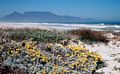
But where to now? We needed somewhere to stay but I think we were all getting a bit hot and tired, we checked out the local campsite but were uninspired so in quiet desperation we drove a little way out of the town to nearby Goegap Nature Reserve, see 1. A breath of fresh air. It turned out to be a small collection of sympathetically designed buildings and succulent gardens set amongst pleasant hilly terrain and had lots of natural interest, recording 581 plant species , 45 mammal, 25 reptile and 3 amphibian species. More importantly at that instant it also sported an excellent guest house at a very reasonable rate which we were able to book into for a couple of nights. This was an idyllic spot, breakfast on the balcony, no crowds, well, no people and a friendly face behind the office desk.
Above Left, a view from just behind our accommodation, 2, Table Bay, 3, one of many campsites, 4, View from Table mountain and 5, Cape Town Marina. Next to our accommodation. there were well marked trails of various lengths (best early or late as it gets quite warm) and loads of flowers and wild life to check on a tick list booklet supplied by the park.
Back to Springbok and then it was south again down the N7, a long leg of 258km to Vanrhynsdorp where we spent the night at a pleasant campsite just outside the town. Next day we planned to visit the hilly Cederberg Wilderness Area to do some walking but the weather had other ideas and we we were joined by the first clouds that we had seen for six weeks. In gathering gloom and drizzle we opted to stay in a chalet, tempted by a special offer of stay 2 nights get the third free. However, it drizzled and the cloud eventually lowered to the chalet and after the second day we left for the coast having only completed a short waterfall walk in the rain and mist.
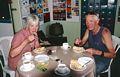
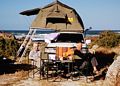
The coastline of St Helena Bay seemed singularly unattractive. This wide, flat swathe of sandy coastline was being heavily developed for holiday home accommodation., amongst which were various smelly bits of industry adding to the general seediness. Fishing and surfing were probably the only occupations along here, even the promised migratory birds seemed to be boycotting it. Around the corner however at the little village of Paternoster things were looking up with a clutch whitewashed cottages with green roofs contrasting with the sparkling sea. Unmissable was the idiosyncratic Die Winkel op Paternoster - cafe, nik-nak shop, store and lots else. Just south was the Columbine Nature reserve at Tietiesbaai, pronounced? Yes. This was a lovely spot in the coastal fynbos, a terrain of small bushes that we were to see a lot more of as we travelled towards the Cape.Picture 3, breakfast at Tietiebaai camping. There were some superb granite boulders here, and where were my rock shoes? Right first time, back in England. Damn!
Getting close to Cape town and picture 2 was our first view of Table Mountain and the one that everyone sees across the long sandy sweep Table Bay. Not tempted for a dip, there were some big cold waves crashing in when we were there and quite a pollution haze across the city; nice flowers though.
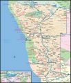
Rather than look for accommodation. in Cape Town we wove our way through the city to Simonstown, a pleasant resort on the shore of False Bay and backing against the Table Mountain National Park which extended right down to the Cape of Good Hope. See the map. The Information office in the town found us some accommodation. seemingly perched on a cliff top just outside the town with superb views over False Bay.
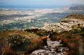
Next day we visited the Cape of Good Hope which is often mistaken for southernmost tip of the continent. Other than the fact that it's an essential tick it was far too busy to be pleasant, with all the roads and parking areas blocked with huge tour buses. It was solid shoulder-to-shoulder tourism at times and we were too dismayed to brave the throngs and visit the lighthouse.Picture 4, a view from Table Mountain. However, world famous as it is I suppose it's bound to be a honey pot area. One didn't need to travel far though to get away from it all, and if you're into old wrecks the coasts round here are littered with them, try Olifantsbos point. Here, the beautiful sandy coastline was strewn with rusty wrecks battered by huge surf.
One can't visit Cape town without visiting Table Mountain. We visited the beautiful Kirstenbosh gardens - that's a full day, then revisited them in order to ascend Skeleton gully, a steep little number with the odd ladder and cable that takes one up onto the plateau. An hour or so's walk on well surfaced tracks allows the highest point to be reached at Maclears Beacon 1087m. Five is a shot of us returning to the head of the gully, Cape Town spread out below. On a following take we took the cable car (queues!), explored some more of the summit then descended the nearby Platteklip Gorge, some 750m - my knees have almost recovered! The summit of Table Mountain consists of a pleasant network of well maintained paths with various gullies, peaks and reservoirs to explore. There are many ways off the summit, some tougher than others. We used Peter Slingsby's Table Mountain National Park Map 1 1:20000 which is widely available.
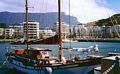
Next day we checked out the city which, apart from the waterfront is more business than tourist orientated. Picture 5, the Cape Town waterfront is where everyone goes, there are lots of shops and restaurants, twee bridges over the marinas and an unmissable aquarium. It poured with rain when we were there so we were quite glad that there were things to do and shops to visit. Six, the waterfront, Table Mountain behind.
Time to move on. We decided to move down the coast a little way to the town of Hermanus, whale watching centre of South Africa, this was also close to the N2 giving easy access to the airport. We packed the camper and headed round the edges of False Bay. Flat at first, one is soon passing underneath the interesting and sometimes rocky flanks of the Koeelberg and Buffelstalberg mountains as one heads round the tip of the headland towards Betty's Bay.
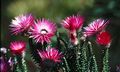
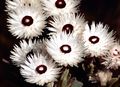
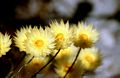
Hermanus turned out to be a pleasant little town, orientated towards holidaymakers and whale watchers. The Tourist Information office sorted us out with an excellent flat close to the middle of town, we did some shopping, pottered around the town and we were all set up. Next day we walked down the coast watching Southern Right whales, some with calves leaping out of the water and slapping there tails down such that it could be clearly heard. Eventually I dug out my telephoto lens, which was a signal for them all to submerge. Eventually we ran out of navigable coastline and we headed into the adjacent Fernkloof Nature Reserve. This extensive fynbos contained some wonderful flowers, many of them helichrysums - everlasting flowers. See above.
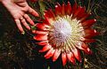
Pictures 1-5, possibly Phaenocoima prolifera, Helichrysum vestitum and ??? but there were lots of them. There was also a wide variety of Protea.
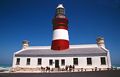
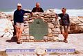
The last objective, the southernmost point of Africa, Cape Agulhas, needle cape. OK, it may be flat but it does have a lighthouse that one can ascend and a monument indicating that it's the most southerly point and that this is where the Indian Ocean meets the Atlantic. I checked the temperature of the water on the Indian side - freezing. There's something about peninsulas that I find irresistible, particularly when there's a big sea running. Out there the next stop was Antarctica.
Left Agulhas Lighthouse,right, that's us..
Check out Jenn Miller's excellent 100 best things to do in South Africa a 2018 website. It is over 10,000 words and packed with practical tips and advice. All the things we should have visited but missed out.
Namibia and South Africa, October 14 - 31st, 2005 Party, Chris and Sue Jackson, Mal and Bob Roe.
Costs/person including Namibia
| Flight Manchester - Windhoek, Cape Town - Manchester, each | £773 |
| Vehicle Hire, insurance, pick-up fee (total £5288)/4 | £1322 |
| Food + camping + parks + fuel, each | £306 |
| Exchange rate - approx Rand/£ | 11 |
Petrol 5.5 - 6.5 Rand/L
Camping/person 30 - 60 Rand