
May 13th to July 5th 2012
chris and sue jackson e-mail
Click on any thumbnail image to enlarge.
We, that is Sue myself and the campervan left England via Harwich to the Danish port of Esbjerg on The 13th of May with DFDS Seaways, a rather expensive ferry company operating from Denmark. The voyage took about 18 hours. At one time it was possible to take a ferry direct from the UK to Norway but currently all of these have been discontinued. Another option apart from Dover-Calais is Hull to Rotterdam which of course involves a lot more driving through Holland, Germany and Denmark. Once in Denmark it was a four hour drive beside flat fields and small farms to our next port of departure, Hirtshals for Colorline Ferries and then a 3.5h crossing to Kristiansand in Norway. By coincidence, sister Marilyn and husband Bob were also embarking on a Norway holiday at the same time and we spent the first week or so with them before we went our separate ways.
For those less than familiar with the map of Norway, Kristiansand is right at the bottom, not far from the most southern point at Lindesnes. Kristiansand should not be confused with Kristiansund which is a long way further north near Trondheim.


May 16th, Initially, the weather wasn't very good, with low cloud and drizzle but then you don't visit Norway for the sun. Together we visited the lighthouse at Lindesnes, the most southerly point of Norway and pottered around some of the rocky inlets before heading up the coast towards the town of Flekkefjord. We spent a night at Egenes Camping and next day after a lazy start waiting for the weather to improve we did some boggy walking up Simonskyrkja 424m. The following day was glorious however, and after some not very successful shopping in Flekkefjord we set off down route 44 towards the town of Hauge. Two years ago Sue and I had discovered this scenic treasure chest of route 44 and were keen to explore it a little more. Above, scenic gems, L-R the village of Roligheten, That's us near the summit of nearby Brujfell, The village of Ana-Sira, rock rock rock, reflections at Sognadalstrand, boats and the road to Jossingfjord.
We stayed two nights at a Bakaano Camping near the small town of Hauge, pleasant but it was the most expensive site on our entire holiday at NK255, about £28/night including hook-up.
Next morning we set out to have a go at Norway's largest rocking stone, the Ruggerstein but despite combined tactics there wasn't a hint of a rock and it only weighed about 70 tonnes! However, on returning home I found a clip on You Tube showing a couple making it rock, I think that we may have been pushing at the wrong end! We visited the very pretty Sognadalstrand and nearby Nesveg for a walk without a map. What appeared to be a simple circuit on our road map turned out to be anything but simple with lots of glaciated domes of rock and scattered lakes. After making a summit we headed out on compass which almost worked except that we were left with a 5km road walk back to the camper.
Next day Marilyn and Bob left to make their own way up Norway, Sue and I backtracked to the rocky valley of Helleren to check out some ancient houses built into the overhanging rocks and to Bu on the splendid Jossingfjord where we were able to wander along the coast then over the hills to make a circuit.
May 21st. We visited the nearby town of Egersund for supplies, stayed overnight at the campsite there then headed for the hills. The highest peak in Egersund is Store-Skukula at 906m. Not one to recommend in early spring however, there was lots of snow around, even more bog and the summit resembled something from a bad day on Bleaklow, a low hump part shrouded in drizzle. Undeterred or somewhat undeterred we continued north to Veen where we chanced on a delightful Gardscamping site. The campsite was perfectly positioned for an ascent of Vinjakula 907m, the highest top in Bjerkreim


So, L-R Sue and Vinjakula, lake on Vinjakula, Sue on Snow patch, Sue on summit, Chris on summit and back on the E39. This was a splendid mountain, low on bogs and high on rock and a full day out. The weather turned hot and we had to down lots of chilled beers to counteract dehydration when we returned.
May 23rd. Perhaps we should have stayed longer, the weather was perfect, the hills inviting and the campsite was in an idyllic setting but for some reason we took to the road again. Good day for a drive through stunning scenery though. We pressed on north up the curiously named Gloppedalen, to join the 45 and west towards Stavanger. We had visited the city once before and though it was well worth the stop-off we didn't feel inclined to repeat the experience. Onwards and upwards we joined the E39 through Sandnes, bypassed Stavanger and took the ferry from Mortavika to Arsvagen (NK 189) then up the beautiful chain of islands past the town of Haugesund, through Leirvik to Bortveit where we took another ferry to Hodnanes and onto the island of Tysnesoy. There we found a sleepy campsite on the north end of the island, though we were never sure whether or not it was actually open, NK170 including hook-up was very reasonable for Norway. The following day we sort of planned to go to the town of Norheimsund where there was a chance of doing some walking but there was so much snow that we changed our minds and headed instead towards Bergen
The problem with snow on high level routes is more than just getting it down ones boots, the trails remain unopened, waymarks are buried and bridges over torrents, which are often taken down late autumn await reassembly.
May 24th. We pressed on past Bergen which we had visited before, and still on the E39 over a huge bridge to Knarvik, and then, after crossing the Austfjorden we peeled left onto the 57 which seemed to lead into a maze of islands. At Masfjorden, another ferry but with a difference, this one was dragged across the water by cables, probably the last of its breed. Exhausted, we stumbled on a small Nautesund Camping which was mainly huts (hytte) near Risnes in idyllic position above fjords and islands. However, we'd also stumbled upon a Norwegian holiday as it was Whitsuntide. We were squeezed in for one night only.


At about 4.00am I got up to answer a call and chanced to draw the curtains for a look outside. Wow, seconds later I was stumbling down to the sea clutching camera and dressed in er, not a lot. The view was breathtaking, the fjord was like a mirror and in the distance snow capped mountains glowed in the early morning light
Evicted, we pressed on northwards zigzagging our way amongst islands and across fjords. The ferry at Rutledal only ran every two hours and as we had just missed one we headed down the coast to Oppedal where they were more frequent (NK96). North again on the 607 and the 57 to the town of Dale, a particularly scenic area. Another ferry (NK96) took us to Eikenes but at nearby Askvoll we failed to locate the campsite though we did manage to buy a map at the local sports shop. We pressed on around the end of the Sunnfjord peninsula and eventually wild camped at Strongfjorden. This was a pleasant collection of houses, an open car park area, a marina and very few people, We were kept amused by three girls and a tent. Despite a joint effort over 2 hours it was just a good job that the weather was set fair! It also just happened to be right at the start of a track leading into the hills.
May 26th. This proved to be an excellent walk in perfect weather though we failed on our ultimate objective Moldura 837m as there was too much snow, the last 100m being hard snow above a gaping ravine. Crampons and ice axes rather than bendy boots and trekka poles would really have been required to prevent a potential disaster. Below, L-R Walking in Sunnfjord, the illusive Moldura, Krakanes lighthouse, Chris and the Kannesteinen rock, walking above Maloy and on the way to Runde.

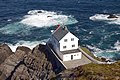
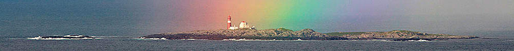
May 31st. After several diversions, we arrived at the island of Runde which is joined by bridge and causeway to the mainland, for a change. We stayed at Goksoyr Camping, a delightful little site right on the edge of the sea (NK190 hookup and free wi-fi) . The island cliffs were home to numerous sea birds, puffins, gannets and many members of the auk family have colonised the 600m cliffs. In the air were numerous great skuas as well as Golden and White tailed eagles. A tickers paradise. The weather was fairly active but during the weather windows we managed to see most of these birds as well as visit the remote lighthouse on the tip of the island.
Something horrid this way comes..


The glorious weather of a week ago seemed like a different world where 25C had been exchanged for 6C as a deep depression over the Baltic pulled cold and unsettled weather onto us from northern Russia. Still, the clouds were dramatic. L-R Waiting for the Puffins, Puffin in the snow, Squall over Grasoya lighthouse, Golden eagle, White-tailed eagle and Great Skua.
June 3rd. Alesund in the pouring rain where we squeezed into a soggy campsite on its outskirts. Next day the rain eased and we were able to walk into the town. It turned out to be a pleasant place with interesting architecture, museums and a restaurant on a hilltop giving splendid views over the city.


L-R Alesund from the bridge, Sue and the Herring lady, architectural decorations and a view of Alesund from the hill top restaurant.
June 5th. After some shopping we headed north again, crossing two ferries on our way to the town of Molde, via the fine little islands of Midoy and Otroy. Something strange happened in Molde, the sun broke through the clouds and magically they began to disappear. We pressed on up the 64 for a few km before turning left onto the 664 which took us to the small sea side town of Bud. Here we discovered the tranquil Plus Camp (NK240) on the edge of the sea. This was a lovely spot with chalets and mountains mirrored in the glass smooth waters. We also discovered a pleasant half day circular walk in the hills above Bud. Five little tops of Gulberget, each with its stunning view and summit book to fill in.


L-R View of Bud, Saithe - a member of the Pollack family free from a friendly fisherman, view from Gulberget, filling in a summit book, a summit and early morning view across the fjord.
June 7th. Back on the road again in glorious weather, along the Atlantic highway, one of the world's best drives if you believe Jerome Clarkson. The road leaps from island to island by long connecting bridges, the most photographed one being below. The sea was alive with fish and the gulls were going mad. Too soon, Kristiansund and the ferry from Seivika to Tommervog which took us to the beautiful islands of Tustra, Ertvagoy and Aure and the village of Kyrksaeterora and the small pleasant site of Skogrand Camping (NK190)
June 8th. Joined the E39 again on its way to Trondheim but diverted to the ferry at Flakk and across the Trondheimsfjorden to Rorvik (NK170). We pressed on northwards, still hugging the coast and with the snow capped hills over on our right. Each time we tried for a walking area we found that the snow was too low and all the trails were covered, however, there was another reason for our northwards drift. Around the town of Mo-i-Rana is an area of limestone, something fairly rare for Norway and Sue, being an orchid sort of person hoped that the area would be knee deep in Ladies Slipper orchids and other exotica. Hah!
So on we went, the coastal scenery remained superb and the snow line to the east got relentlessly lower. Through Namsos and along the 769, across a ferry from Lund to Buoy and then along the coast to Kjelleidet and the pleasant Svaberget Camping. In the evening light the splendid Heilhornet mountain (1063m) and its satellite hills glowed in the warm sunlight. It was a fine objective for tomorrow, but next day it remained deep under cloud and rain and having no serviceable map we were forced to abandon the attempt and move on.


L-R Bridge on the Atlantic Highway, hill above Svaberget Camping, view from same hill and Heilhornet.
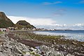
All was not lost however, and we had information about a small island called Leka which, despite its diminutive size, 30km circumference, contains a wealth of interest. It has a population of about 880 and has been occupied for almost 10,000 years. The geology is amazing with rugged hills of yellow and red rock pushed up from the mid-atlantic ridge, it is also the site of the abduction of a 3 year old girl in 1932 by an eagle. She was eventually found on a mountain ledge by locals after one of her shoes was discovered at the base of a scree slope. She was unharmed except for claw marks. There was some excellent walking to be had on this tiny island.


L-R Campervan on Leka, Leka mountains, Mountain Avens (Dryas octopetala), Diapensia (Diapensia lapponica), Walking on Leka and Moss Campion (Silene acaulis).
June 11th. The weather remained unsettled and we continued north up the next long chain of lonely islands linked by ferries. Holm to Vennesund, Horn to Anndalsvag and Farvik to Tjotta ferries. On the way we stopped off at Bronnesund and made a side trip to Torghatten, the famous mountain with a hole through it. Next day we pressed on again in mixed weather. through the industrial city of Mosjoen with its pleasant old town and up the E6 where we expected to encounter a long road tunnel but which turned out to be closed and we were diverted over the old road. For the best actually, the views were stunning but the amount of snow was depressing, I recalled visiting the Alps in February to less snow than this. At Korgen we discovered a pleasant little campsite with an honesty box for NK 150, one of our better discoveries.
June 13th we headed into the hills hoping to do some walking but the snow was so deep than none of the trails were open and we consoled ourselves by walking as far as possible along the forestry track which took us about 2 hours. One of the local sights was the pothole, a deep shaft worn out be stone erosion at the end of the ice age. It was not easy to find buried in the woods and, well, those who have visited the Yorkshire Dales should not bother.
June 14th. The unsettled weather continued. We visited the town of Mo-i-Rana and checked out the nearby areas where there were two show cave, looking for Sue's illusive orchids. Not one. The snow had only just vacated these hillsides and the vegetation was either flat or in dense impenetrable woodland. One more try for something special was our search for the Marble Palace. This took some finding, signs were few, there were long sections of unsurfaced road and much hacking through wet woodland before it was discovered. It turned out to be a section of river gorge cutting through marble rocks. Nice but marginal regarding the amount of effort it took to find it.


L-R Sue at Hole Mountain, Ostrich ferns, Marble Palace, Chris at Marble Palace, Creeping willow (Salix myrtilloides) and Lesser Twayblade (Listera cordata)
June 15th. Enough was enough, no orchids and too much snow we headed south again. South, south, south, through the traffic jams of Trondheim to a campsite just south, then next day south again to Oppdal where we picked up supplies, then west on a splendid stretch of the 70 to Sunndalsora, on to the 62 and the 660 until we could enter the deep, blind valley of Eikesdalsvatnet which contained Mardalsfossen, Norway's 4th highest waterfall of 297m unbroken drop. The valley was stunning with huge crags either side of the fjord. The waterfall was not quite as impressive as much of its water is taken for hydroelectric generation though at certain times extra water is allowed to go over the falls. Sue was more excited by her discovery of the diminutive Lesser Twayblade (Listera cordata) which is uncommon in the UK. The campsites were crowded here but we easily found a pleasant spot to wild camp.
Missing our walking we decided to head for a more westerly range, the Sunnmore Alps which was popular centre for walking. We stayed at the campsite in the town of Orsa on the western side of the hills and were able to obtain walking maps from a book store in town. Next day we managed an ascent of Sandhornet (909m) in less than perfect weather. Through the clouds and driving sleet we glimpsed a lot of snow on the surrounding hills. Above the town was Saudehornet, a fine looking peak plastered in snow where a skier had recently been killed.
June 20th-23rd. West of the main Sunnmore Alps is an area known as Vanylven, we obtained a map and scanned it for likely targets. The hills were lower and there were lots of trails marked on the map. Next day we were off. Good choice, the sun shone and there was plenty of walking to be had, some of it rough and unfrequented. We climbed Storabora 785m, descended in the wrong place and encountered some very rough walking, and next day Storakrok 654m, a long trek over unmarked ground. The downside was the flies, and though they weren't quite of Australian proportions and they didn't bite they were something of a nuisance. Once in the valley, they all disappeared, obviously mountain flies. We didn't locate a campsite in this area but we did locate a pleasant picnic lay-by with an immaculately clean toilet and we wild camped for 4 nights here.


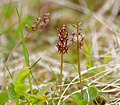
L-R. Sue and the Mardalsfossen falls, Summit of Sandhornet, Summit of Storabora, Greater Butterfly orchid, Heath spotted orchid, summit of Storakrok.
After our stay in Vanylven we headed for the town of Olden on the north side of the Jostedalsbreen glacier. This is a large and complex glacier but has easily accessible snouts than can be visited with only moderate effort. At Olden we stocked up with food and headed up the Oldensvatnet valley to the campsite at the end of the road at Melkevoll. This was such an amazing site, behind was an enormous Volefossen waterfall and up the valley and to the other side were huge blue glaciers of the Briksdalsbreen glacier. The campsite was perfect, with large, well drained pitched amongst huge boulders, there was even a bouldering circuit for those who had brought their rock shoes.


June 24th. We walked up to the Brikdalsbreen glacier, an easy 40 minute walk from the campsite though the route was heavy with coaches as far a Briksdal and then people carriers which took them to within 10 minutes walk of the glacier. It was busy, but not as busy as 2 days later when two liners moored in the fjord and I counted at least 15 coaches heading up the valley. Big money; talking to a couple from one of the liners, they said that it cost £180 to be coached up the valley. However, we arrived at the glacier before the crowds and got some splendid views.
Above, L-R Distant view of the Briksdalsbreen glacier, on the walk up, glacier across the lake, a Twinflower (Linnaea borealis), Common spotted orchid (Dactylorhiza fuchsii) and the waterfall behind the campsite. The Briksdalsbreen wasn't the only glacier and next day we visited the Brenndalsbreen glacier, and easy 1 hour walk from the campsite, no crowds, no buses, lots of flowers and an active icefall. This was a special place, we only saw one girl fell runner and a couple of workmen repairing a ladder over the two hours that we spent there.


Above L-R The threatening icefall above the Brenndalsbreen glacier, Chris below the glacier, the glacier stream, Pyramidal saxifrage (Saxifraga cotyledon), a higher view of the Brenndalsbreen and Sue and the outwash from the glacier.
June 26th. A rainy sort of day spurred us into returning to Olden for some shopping then to visit the next valley to the east, the Lodalen. This was quite a different sort of place, quiet and unspoiled, we stayed at Tjugen Camping, perched above the valley with splendid views. After settling in we did a short walk in the forest and got wet, but things were on the mend. Next day in perfect weather we drove to the end of the valley then walked along the private road to the Kjendalsbreen glacier, a beautiful and almost level walk.


L-R Kjenndalsbreen glacier, waterfall on the walk in, Bodalsbreen glacier, view across the lake to the Bodalsbreen and Sue and the glacier. There was a wealth of alpine plants growing here and it was difficult to get Sue away!
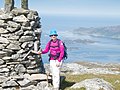
June 28th. We were beginning to get a little bit over-glaciered, but the weather remained perfect and there was just one more to visit. This was the Bodalsbreen glacier, which was at the top of a 650m high toll road. Campervans were not recommended for the road so we parked at the bottom though as it turned out we would have had no problem with it. Still, it made for a full day out and the road passed impressive waterfalls as it zigzagged up to the the collection of huts at Bodalsetter. From there the walk was almost level but we noticed the the trail to the higher, adjacent Bohrsbreen glacier was not open due to the depth of snow on it. The Bodalsbreen glacier had a beautiful blue lake below it and it was possible to walk right up the the glacier ice. Parties of glacier walkers were preparing to work their way up the glacier and a group can be seen on the gallery view.
We intended to spend some time in Oslo, and as our ferry back to Denmark was on the 3rd July we had to move on but next day it was raining so we didn't feel quite so bad about it. We drove back down to valley to join the 60 and then our old friend the E39 which took us over a high pass which cut through the west end of the Justedalsbreen glacier. We left the E39 at Skei followed the 5 southwards through the town of Sogndalsfjora and over the ferry from Manheller to Fodnes and Laerdals where we entered the world's longest road tunnel, 25km from Laerdals to Aurland. Here we stopped at the pleasant Lunde camping.
Two years ago we had stayed here and walked down the Aulandsdalen valley in the rain, a great walk in poor weather. Since then Sue has wanted to repeat it in the sunshine. No such luck, the forecast for the next several days was rain and more rain. Next day we drove over the high Aurlandsdalen, route 50, an amazing road with literally dozens of road tunnels, past the starting point for the Aurlandsdalen walk - just visible through the rain and cloud. It was a dramatic high level road with many of the small lakes still frozen over from the winter. Eventually the road lost height and we entered the land of the living with trees, greenery and houses. At Hol we stopped to visit the beautiful stave church, at Gol we stopped for food and LPG and eventually to Orpen for an overnight camp at a tiny site on the banks of the Ekroderen lake. NK180 seemed quite a lot for simple facilities but I suppose that we were approaching Oslo.
We were now within a few hours of Oslo and next day, thanks to Sue's uncanny navigational skills we arrived at our destination, boggy Bogstadt Camping without any problems. We booked in for 3 nights which at NK255/night excluding hook-up seemed quite steep. However, it was a good base for exploring Oslo, the 32 bus took us to the T-bane station, and the train took us to the city centre. Easy. Sue's calculations showed that the Oslo card (NK120, half price pensioner's rate) easily beat the cheaper travel card when museums and ferries were put into the equation.


L-R Above, on the high level route 50, the stave church at Hol, Oslo main street with the Presidential palace, the Nobel Peace Centre and the Oslo Folk museum.


The Folk museum was excellent, with an extensive indoor section and an even more extensive outside section with parkland, working villages and folk dancing. There were lots of old authentic chalets, an old church and people making and doing things in a traditional manner. And a cafe. L-R bread making, wood carving, transport, dancing, Oslo street musicians and another Oslo street musician playing a very respectable Eine Kleine Nacht Musik.


Not to be missed are Oslo's museums though they do tend to get rather busy, particularly the Viking exhibition. The Viking exhibition was excellent with lots of original Viking remains and longships recovered from the ground. For me, the Fram exhibition was perhaps the highlight of the day with the great Norwegian Arctic and Antarctic explorer's boat renovated and available to wander round. There was lots of information about Scott, Amundsen and Nansen's exploits. Across the road was the Kon-Tiki exhibition with reproduction rafts.
L-R Viking longship, Viking longship, Viking carving, Nansen's ship 'The Fram' , Thor Heyerdahl's Kon-Tiki and the cliffs of the Moler coast in Denmark.
So, that was almost it. We packed up and headed for Kristiansand to catch the early ferry to Hirtshals in Denmark then wandered our way across country to the extensive lake area known as Mors. We crossed a lake on one of the last working all wooden ferries across Feggersund and landed on a delightful Gerlis Camping where we spent the rest of the day. Next day we pottered along the Moler coast, a strange land of low chalk cliffs interbedded with layers of volcanic ash before making the final push to Esbjerg and the ferry home.
Why to go? Amazingly beautiful scenery, empty roads, friendly locals, English widely spoken, low crime rate.
Why not to go. Expensive, can rain.
chris.jackson@zen.co.uk
Go to Top