Sardinia and Corsica 2013. Eight weeks by campervan, exploring and walking.
chris and sue jackson e-mail
![]()
May - July 2013. This is the story of our 2 month trip through France to Sardinia and Corsica over May and June. It started however with a bit of a disaster when Sue dropped my wallet containing all my cards onto the péage of an Autoroute near Marseilles. So why didn’t she pick it up, you ask. Well, we didn’t discover the loss for some hours. Not only cards but my driving license too. We managed to stop all the cards and so had to rely on Sue’s cards. Not all bad then.
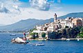
We sailed from Marseilles to Sardinia on an overnight ferry to Porto Torres at the north end of the island, but prior to that almost had another disaster when we got stuck in horrendous traffic in Marseilles, only resolved when I performed an alarming and probably illegal U turn out of the congestion, midst flashing of lights and honking of horns when we spotted a sign reading ‘Docks’ pointing in the opposite direction.
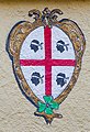
Above, the Sardinian flag. The flag is of medieval origin, and is composed of the St George cross and four heads of blindfolded Blackamoors which more recently have been turned towards the left and their blindfolds lifted. The Moors represents four heads of beheaded Saracens, and symbolise the victory of the Sardinia people against the Moors who attempted to invade the island. It is historically linked to the flag of Aragon in Spain and that of the neighbouring island of Corsica. So now you know.
Click on any image to enter the Gallery of larger images.
We took a three days to drive down to Marseilles, and we stopped off in Laon and then in Provence for a couple of day’s walking. As usual, I woke about 5.00 am and so went for a walk around the deserted town of Laon.
- Laon Cathedral at daybreak, we stopped here overnight in an Aire de Camping
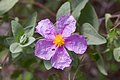
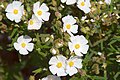
- Cistus Cistus cretius
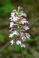
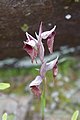
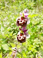
- Lady orchid Orchis purpurea
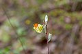
- Orange tip butterfly Anthocharis cardamines
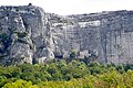
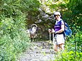
- Chapel of the Grotto of Mary Magdalenes set into the cliffs of St Baume.

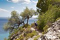
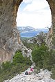
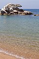
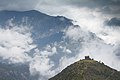
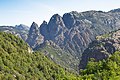
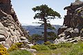
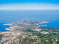
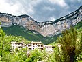
This was our first glimpse of the area and we did a couple of walks not far from the campsite. The main mountains of Sardinia are in the centre and east of the island but the cliffs on this northwestern corner were quite spectacular. We walked route 1 in the Rother guide and route 22 in the Sunflower.
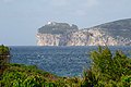
- Capo Caccia
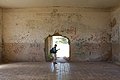
- WW2 army barracks with original graffiti and a faded painting of a battleship. See gallery.
- Sage leaved Cistus Cistus salvifolius
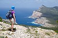
- Sue and the cliffs of Torre della Pegna.
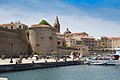
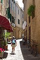
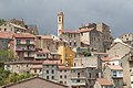
- Alghero old town
- Alghero old town
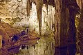
- Neptune’s Grotto.
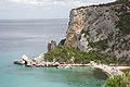
All very scratchy and we soon learned to wear long trousers in the garrigue, the shrubs that cover the hillsides almost everywhere. From Alghero we took a boat trip across the bay, round Capo Caccia to Grotto di Nettuno, Neptune’s Grotto, and very spectacular it was too.
We moved to across the spine of the island along narrow twisting roads and lots of trees and in mixed weather to the town of Tonara where we eventually found Camping sa Colonia, a Caravan Club recommended site. Well, I don't know who recommended it but it was scruffy, untended and with a 1 in 3 hill to descend into it. Caravans, large campers and older Ducatos with a dodgy reverse gear? Forget it. The rain didn't help I suppose but the ablutions under the almost deserted pizza restaurant were surprisingly good. One night was enough and we could easily have driven away without paying as it was a bit of a struggle to find anyone there at all.
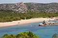
However, as we neared the east coast the weather improved and we found a pleasant Cigno Bianco campsite near the town of Tortoli, and close to the beach. We stayed here for several days and used it as a base for several excellent walks, taking the campervan out each day to different locations.
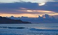
- Sunrise over the beach near our campsite.
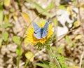
- Swallowtail butterfly Papilio machaon
- Path on the coast near Santa Maria Naverrese, walk 30 Rother guide.
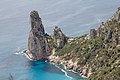
- On route to Punta Giradili. This was an excellent walk into some unlikely territory, walk 31 Rother guide. Big rock climbs here.
- Pedra Longa from below Punta Giradili, walk 31 Rother guide.
- Every tea time is G&T time.
Onwards and upwards, we drove to the pretty town of Cala Gonone where I had been on several previous occasions for the rock climbing. The campsite Camping Cala Gonone was, well, very Italian and a bit disorganised with too many trees and difficult parking, but all the necessary facilities were there. However, I don't know where it got its **** rating.
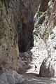
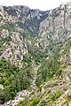
From Cala Gonone, we visited the Gorropu gorge, a bit of a tourist trap with very limited parking but worthwhile despite being charged 5 Euros each for the pleasure including discount for the mature. Walk 5 in the Sunflower guide, taking about 4 hours return. From the parking it was also possible to visit the Neuragic village of Tiscali which Sue and I had both visited before.
- Gorropu Gorge.
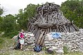
- Lost in translation 1. (see gallery)
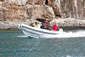
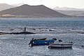
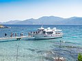
We undertook a long walk along the coast from the tiny bay of Cala Sisine back to Cala Gonone, The Rother guide (route 21) gave it six and a quarter hours, we made it in seven and a half but that included a couple of refreshment stops. The route was by no means level though and we logged a total ascent of 972m on my altimeter. This was a splendid walk covering some fine coastal scenery. It was a good day out, starting with a boat trip of 30 minutes from Cala Gonone to Cala Sisine which gave some splendid views of coastal scenery, The Grotta del Bue Marino and other caves on the way..
- A boat like ours but slightly faster.
- Cala Sisine the start of the walk. People can just be seen on the beach (see gallery).
- Cuile Sacedderano, a shepherds shelter near the top of the first peak on the route.
- The rock window of S'Architieddu Luperu, S'Arcada with a distant view of Cala Gonone.
- The bay of Cala di Luna, two and a half hours to go.
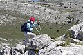
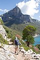
We moved further north, gradually working our way towards our ferry in a few days time. We booked into a campsite near Santa Lucia, hoping that it would act as a base for a long walk on the nearby Monte Albo. Here, the Rother guide let us down and it proved impossible to park our campervan where they suggested, without the risk of not getting it back again. We continued along the twisting minor road to a cafe with a parking area and climbed the nearest peak, Punta su Mutucrone 1050m.
Next day we headed across the island back to the west coast and found a pleasant site near Valledoria called La Foce. Sue’s idea of using local transport to get to the start of a walk was a disaster as we were dropped off miles from where we wanted to be but we learned a lot about buying bus tickets.
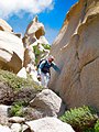
Near the town of Santa Teresa Gallura is an almost-island called Capo Testa which gave us some fine walking in rugged granite territory. There also appeared to be a substantial number of 1 and 2 pitch climbs and endless bouldering possibilities on some very impressive lumps of rock. See gallery
- Sue on the last few feet of the mighty Punta su Mutacrone
- From near our campsite at Santa Lucia.
- Sue on the circuit round Capo Testa, Rother route 6.
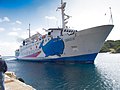
We travelled the short hop from Sardinia to Bonifacio in southern Corsica on Moby Lines. This was our most expensive ferry ride working out at over £2/minute for the 45 minute crossing. Pretty boat though.
- Moby lines, the good ship Giraglia.
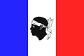
- Corsican flag, now un-blindfolded as with Sardinia.
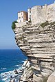
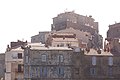
Bonifacio, a fascinating fortified town, famous for its cliff-top houses, one of which collapsed into the sea in 1966 killing two women in the process. There is still some concern and insurance may be a problem! However, we did a pleasant walk along the cliffs from the town which gave some excellent views of the city and coastline. Route 40, Sunflower guide.
- The cliff top houses of Bonifacio.
- Bonifacio
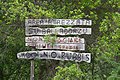
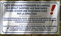
- Lost in translation - 2, sign at the campsite. See gallery.
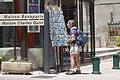
- Bonifacio, Sue and the post card shop.
We stayed at the pleasant Pian del Fosse campsite about 4km outside the town. Parking in town is the usual nightmare and we were very lucky to chance on one. Getting out of it was a bit of a challenge though, I don't think that it was designed with campervans in mind.
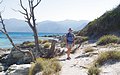
We fled the crowds of Bonifacio and drove to the small town of Tizzano on the southwest coast of Corsica. This remote area sports a couple of excellent coastal walks, Rother guide 31 and 32, each taking about 6 hours.
We found Camping L’Avena near Tizzano which was basic but OK but required us to drive along a dusty track for a few km to reach the start of our walk. The next day we moved to the nearby town of Campomoro and Camping Peretto Les Roseaux. Fortunately we were able to start our walk from the campsite as it was impossible to park a campervan anywhere in the town. Be warned. A pretty, touristy town, Campomoro sported an excellent and clean beach.
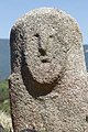
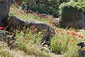
From Campomoro we drove towards Ajaccio, calling in at the ancient stones of Filitosa and losing a mud flap to the car park there. Strange stones that no one really understands though there are lots of theories. The site was first occupied 8000 years ago.
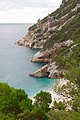
- Between Tizzano and the Cala di Conca. Lots of curiously shaped granite.
- Between Tizzano and the Cala di Conca, one of many fine beaches.
- One of the mysterious stones of Filitosa.
- Flowers at Filitosa.
- Fleabanes and a Wall Brown butterfly Lasiommata megera.
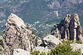
After Filitosa we continues to Ajaccio at Camping les Mimosas which was good though without our satnav we would have had trouble finding it. The town is backed by the huge precipice of Rocher des Gozzi and by driving to the village of Appietto we were able to pick up the track to its rocky summit, Rother 26. The route description in the Rother guide is in need of correction. The best parking is now at Chapelle san Chirgu and the original footpath is now open, the bypass mentioned is badly overgrown and best avoided. Spectacular views and I suspect, a popular climbing destination with some impressive rock architecture. Rather than retrace our steps we climbed the nearby Punta Pastinaca and made ourselves a circular walk.
We moved on to Corte the old capital of Corsica and stopped off on the way at the Cascades d’Anglais. Well, OK I suppose but they wouldn’t get more than a footnote in Norway though the drizzle didn't help the general atmosphere of the place. Further down the road the weather became more threatening but it was all bark and no bite.
- Rocher di Gozzi climbing. See Pedra di Luna climbing guide
- Cytinus hypocistis Parasitic on Cistus
- Cascades d'Anglais
- Storm?
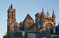
Corte turned out to a spectacular small town with an impressive fortified centre on an elevated rock. There were several campsites around the town, we ended up at Camping Restonica, basic but OK but with a rather narrow entrance. From here we were able to explore the rocky Tavignano valley (Rother 59) though the adjacent Gorge de Restonica was closed to us as campervans were not allowed up its narrow road.
- Corte.
- Corte.
- The Tavignano valley.
- Tongue Orchid Serapias lingua.
- The well made track into the Tavignano valley.
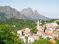
From Corte we drove cross country on the D84, Scala di Santa Regina the old Road to Hell. It's been improved over the years, though still incredibly convoluted and with narrow bits and overhanging rocks, however the scenery made up for all that frantic steering wheel twirling. Eventually, we just chanced on Camping Acciola near the village of Evisa. What a gorgeous site, the position and view more than made up for the lack of motorhome service point. The amenities were also immaculate.
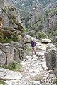
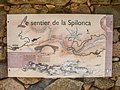
The following day we walked down the road and through Evisa, picking up a baguette on the way, to the entrance path to the Spelonca gorge, Rother 18. This drops for 600m into a valley via endless zigzags. Easy going down but we would have to climb out at the end of the day. The gorge was scenic and we walked along its well-maintained paths to the village of Ota to check out possible campervan parking for a walk around the peak of Capu di Larata, Rother 17 (there wasn't any) and to have an ice cream (success). As anticipated, it was along hot haul back out of the valley and it was seven and a half hours back to our campsite.
- The village of Evisa
- All about the Spelonca gorge.
- I thing that I'm being followed...
- Spelonca gorge.
- Evening view from the campsite.
From Camping Acciola we headed down hill to the town of Porto, a beautiful place with marina and Genoese tower, ice creams, kinick-knack shops, a beach and lots of people but worth exploring all the same. We found a campsite at Sole e Vista, handily adjacent to a supermarket and within walking distance of the town centre. The down side was that it was in terraces stretching for about 1/2 km up the hill. Still, wifi was free.
We were warned about traffic congestion on the Calanche road leading to the start of our next walk, an ascent of Capu d’Orto 1294m, Rother 21. We started early and there was no traffic but on our return the road was gridlocked with coaches and vans trying to pass each other on a single track road. Eventually we tailgated a coach and somehow made our way through. It’s a pretty stretch of road with lots of curiously shaped red granite rocks above an azure sea but I think that it could do with some sort of traffic management, but then, I suppose that it’s self regulating. When it’s full it’s full.
Capo d'Orto turned out to be a splendid rocky peak with some scrambling required to reach it summit boulders. The views were fantastic and we could pick out our campsite 1000m below.
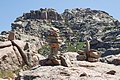
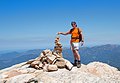
- Cairn building has reached new levels of sophistication here. behind, the rocky summit.
- On the way.
- Another little stone wouldn’t do any harm.
- Looking down towards the campsite.

North from Porto is another road with a reputation, the D81 to Calvi though this too has been improved and apart from the convolutions was really no problem. At Calvi, we booked in to Camping Les Pinedes, a big shady site near the sea. The weather was warming up now and temperatures were already into the low '30s. We planned our last great walk, an ascent of Capu di a Vita 703m, starting from sea level, Sunflower 17.
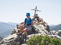
From the campsite we got sort of lost which added about 20 minutes to our walk while trying to find the correct road out of town. Eventually, on route we headed up towards the chapel of Notre Dame de la Serra. Sue appeared to be flagging, not her usual self, and she complained about the heat. Fair comment, it was hot. I made encouraging noises and we pressed on gaining height first by a broad track then by a scrambly hillside with lots of awkward boulders. Sue became more distressed and you could have wrung her out. About to turn back we spotted the cross on the summit and it looked oh so close, but it wasn’t, it was just very big. Slightly encouraged she plodded on and it was the best part of another hour before we popped out onto the top.
She immediately cheered up, talked about butterflies, signed the summit book, posed for a picture and then the scratchy prickly descent down the other side seemed to present no problems.
Deserting Calvi, we drove up the coast then across the Desert des Agriates to the town of St Florent and Le Kalliste Camping. Cold showers and expensive (€30) this was not one of our best buys. We walked into town and booked a boat trip to Plage de Lotu. Next day we sailed there and walked back from Plage de Lotu to St Florent, hot, dusty and not one of our great excursions. We should have stayed on the beach at Plage to Lotu like most people did and taken the boat back in the evening.
- Calvi across the marina
- The summit of Capu di a Vita
- The view
- Rehydration station.
- Plage de Lotu
- The walk back.
- Calvi
We were both ready for a rest. Next day we drove around Cap Course, the pointy bit at the top of the island, past the schist villages with their history of disaster from the mining of the mineral Amianthus, an asbestos like mineral which caused widespread lung disease; spoil was also tipped into the sea, causing devastating pollution and destroying local fishing.
We continued round the tip of the peninsula and down the east side to a paradisical La Pietra camping at Marine de Pietracorbara. ACSI site (we have the card), €15/night, pool, free wifi, immaculate facilities, nearby beach, sun-bronzed ladies. We stayed there 3 nights before getting the ferry to Nice.
Saturday morning we caught the SNCM ferry from Bastia to Nice. It may have been the cheapest but it was almost certainly the slowest taking 7½ hours against other ferry's 4½ hours. We arrived in Nice at about 6.00 PM.
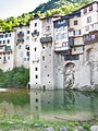
I think that without our satnav we would still be trapped in Nice, going endlessly round its one-way systems. It was amazing, we wormed our way through the evening rush-hour and within an hour of arriving back in France we were tucked up in a pleasant campsite at Camping la Val Fleuri in Cagnes sur Mer. We still had several days to spend before our ferry back to England and we deliberated long and hard as to where to base ourselves. In the end we chose the village of Pont en Royans on the west side of the Vercors region. Our old 1:25000 maps suggested a couple of good walks starting from the campsite.
It's a pretty village with its amazing Maisons suspendu and delightful back lanes weaving in and out of the old houses. We devised two fine walks from here, with scope for lots more in the region.
- Bee or late Spider orchid
- Choranche and the cliffs of Presles
- The Maisons suspendu, Pont en Royans
- Purple Hairstreak butterfly Quercusia quercus
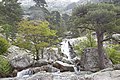
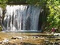
- The White Cascades.
chris and sue jackson e-mail

Costs
- Holiday period May and June 2013 (8 weeks)
- Campervan: Fiat Ducato van conversion, Length: 5.9m GVW: 3500kg
- Ferries:
- Dover Calais Return: £46.50 with DFDS through the Caravan Club.
- Marseilles - Porto Torres: £185 (€210), overnight with SNCM.
- Santa Teresa Gallura - Bonifacio: £93, 50 minutes with Moby.
- Bastia - Nice: £129, 7½ hours with SNCM.
- Total fuel costs for 3400miles: €725, (£627.50)
- Total Péage costs: €301.20; (£255.82)
- Total campsite costs: €1028.60; (£758.59)
- Total food costs: €1278.56; (£1051.75)