![]()
![]()
Australia - Darwin to Perth.
Australia by 4x4. Darwin to Perth, September - October 2011 including the Gibb River Road and other rough bits across this stunning landscape of Northern Territories and Western Australia. Words and pictures. Non commercial, just an account of our travels.
chris.jackson@zen.co.uk
Long overdue, some would say, we seemed to have travelled all over the globe (sort of) whilst missing out this big red dry continent of Australia. Plan A was to drive from Cairns to Sydney down the more popular and populated east coast, but disastrous floods south of Cairns which occurred earlier in the year made us wonder whether the infrastructure would have recovered in time for our visit. This, and the fact that I have cousins living in Perth convinced us to visit the more remote north and west sides. Australia boasts numerous remote off road or unsealed roads as they call them, and not wanting to miss out on the outback experience we hired a high clearance 4x4 campervan from Apollo in Darwin, which we dropped off in Perth two months later. The camper was an almost new Mitsubishi Triton 4x4, diesel automatic with living accommodation. bolted on where a pickup back would normally be.
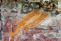
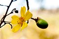
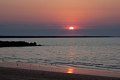
Above, L-R Sue Australia dreaming, Florence Falls and Fish.
It's a long haul from Manchester to Darwin, the total flight time totalled over 24 hours and we arrived in Darwin somewhat jet lagged to be greeted by a humid 35C. I think that it took us both about 3 days to return to normality.
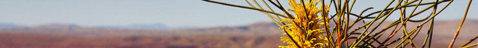
Darwin is located in what is locally known as the 'Top End'. It's in Northern Territories, a state that stretches all the way down to Uluru and Alice Springs right in the red heart of the continent, see maps. Much of Northern Territories and Western Australia consists of an ancient, wrinkled sandstone plateau, cut by deep ravines, some of which are only water active in the Wet. Our experience of the uplands was of endless dry savanna but in the Wet, between November and March torrential rainstorms flood much of the region making road and rail impassable at times. Off road during this period is a definite no-no.
Australia is famous/notorious for its deadly crocodiles, snakes, spiders, sharks and jellyfish but we saw no jellyfish, only reef sharks, no poisonous spiders, a disappearing tail of one snake but a few crocodiles. There are two types of crocodile in Australia, the Freshwater which will only bite if provoked and the Saltwater which bites whenever it feels like it. This is a serious crocodile and warning notices are usually placed at swimming spots.
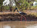
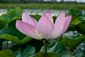
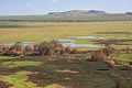
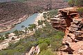
September 5th. We visited several National Parks in the Darwin area, and though they looked close on our map we soon learned that there are some big distances to be covered to get anywhere. On some stretches of road we travelled over 100km without seeing another vehicle. The largest park in NT is Kakadu, some 219km from Darwin, the closest is Litchfield, a mere 78 km. On our way into Kakadu we visited the Corraboree wetlands and took an evening boat trip. Left to right Black-necked stork, Darter, lily pads, lily flower, White-bellied sea eagle and a Salt Water crocodile - not to be messed with despite our guide assuring us that they were gentle creatures and had just had a bad press. On a through trip of Kakadu, beyond Jabiru and the visitor's centre, then down Route 21 to the adjacent Nitmiluk (Katherine Gorge NP) we covers over 700km which included visits to Nourlangie where there were large escarpments and Aboriginal art, Ubirr with more art and Gunlom, 37km of unsealed road to visit a large waterfall which turned out to have almost dried up. Still, it was a pleasant and remote campsite with fine views from the top of the dried up falls.
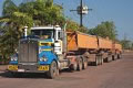
Above, one of the ubiquitous road trains which if it weren't for the empty roads would be something of a challenge to overtake, next some Aboriginal art at Ubirr and views from the rocks above Ubirr across the East Alligator River wetlands.
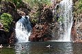
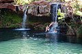
On a spur of the moment we visited Edith Falls which is part of the Katherine Gorge (Nitmiluk) NP. (Drag map) Good choice as this pleasant little campsite was well situated by cooling plunge pools and some even pleasanter walking above the falls where there were more swimming spots. Above left a Yellow Kapok, an unidentified desert flower and Sue above one of the swimming pools. From Edith Falls we went to Katherine Gorge, the campsite was a bit on the expensive side but it was well situated for a canoe trip on the Katherine river and there was lots of wildlife in the campsite. Above, Agile wallaby. Blue- faced honeyeater and Sue in the Katherine gorge.
The Gibb River road.
From Nitmiluk, it is almost 600km to the start of the Gibb River Road, do-able in a day but we decided to break it at the pleasant little NP of Keep River. This is also conveniently close to the Western Australia border where they are very fussy about what is inside and sticking to the outside of one's vehicle. No vegetables, fruit, fresh meat, seeds and especially Cane Toads which apparently have a habit of hitching a ride under cars. The natural range of Cane toads extends from the southern United States to tropical South America. They were deliberately introduced from Hawaii to Australia in 1935, to control scarab beetles that were pests of sugar cane. In 2002, Cane Toads occur throughout the eastern and northern half of Queensland and have extended their range to the river catchments surrounding Kakadu National Park in the Northern Territory and have now been found in Western Australia. The beasts are poisonous and there has been a marked reduction in indigenous wildlife where they are found, including crocodiles.
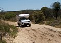
September 15th. We crossed the border unscathed and stopped off a nearby Kununurra for enough supplies and water to last us for 4 or 5 days on the Gibb River road. The road is an old cattle trail which stretches 712km from just outside Kunanurra to Derby, it's mainly unsurfaced though the last 120km to Derby are unsealed. We spurned this last section and continued our off-road experience by cutting southeast from near Napier Downs down through Windjana and Tunnel Creek NPs, a good decision as it turned out. Despite its length, the road does sport various roadhouses where fuel and basic supples can be obtained - at a price.
Above L-R, the start of the Gibb River Road, the Pentecost River crossing, Baob tree at evening, the Windjana Gorge and Tunnel Creek tunnel. At the start of Day 1 we stopped at El Questro Station, a mere 50km from the start of the road but down 16km of track, and having arrived early in the day, we visited the nearby El Questro Gorge where we were subjected to some proper 4x4 track, a nasty little river crossing and some deep dips where we managed to destroy the pull-out step for the accommodation. Good riddance really, it was the lowest point under the whole vehicle and was an incident waiting to happen. The gorge was attractive and there was a pleasant swimming pool at the end, see gallery.
Next day, we set of for the Gibb River Road. Much of it was well graded though there were long sections of corrugations particularly in the red sections of road. Red dust got everywhere in the campervan part of our 4x4, even into cupboards and drawers. Crossing the Pentecost river was quite easy, the water was no more that 60cm deep at the most and this proved to be the only crossing of any significance. Steep bits of the road have now been surfaced and we thought that with a little care the whole road could be traversed by a 2 wheel drive vehicle. The eastern section of the Gibb proved somewhat monotonous and for hour after hour we travelled through endless savannah, indeed a passenger falling asleep for an hour would notice no difference in the scenery on waking up. We intended to stop at Ellenbrae roadhouse campsite,some 160km from El Questro, but arriving early we decided to press on to Mount Barnett Roadhouse campsite making for a long day of some 7 hours monotonous driving. Here there was fuel and a shop, they even sold cold beers.
Up early we continued from Mount Barnett and the scenery soon took a turn for the better as we passed through the Phillips, Napier and Leopold ranges. The road zigzagged up and down rugged little hills and down the sides of narrow gorges, passing intriguing features such as Mac's Jumpup and Stumpy's Jumpup (incline). Mid afternoon, the road divided. Straight on would take us to Derby, but left would take us down another 167km of unsealed road, past two National Parks, Windjana Gorge and Tunnel Creek. Windjana featured a campsite so we stayed there and in the evening explored the gorge. Unexpectedly, this turned out to be a limestone area and the gorge cut through a 100m escarpment of the stuff. It looked to be good quality limestone, eroded into splendid features but there was no sign of it being climbed.
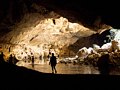
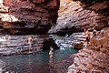
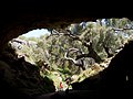
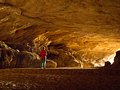
Next day we pressed on to Tunnel Creek NP and explored its tunnel. This was an excellent 750m through cave containing a small stream and pools up to 1m deep, or deeper if one headed in the wrong direction. There were several groups of people wading the cave, there was also a small shy freshwater crocodile in one of the pools. At the exit we chanced upon a large Gould's Monitor lizard over 1m long. A decent torch is required for this trip.
The road continued south with various degrees of corrugation until we met the main Highway 1 road from Kununurra, where we turned left to visit Fitzroy Crossing and stayed overnight. Next day we took a boat trip on the river down the pleasantly craggy Geike Gorge NP where we saw several crocodiles. Interestingly, the Fitzroy river is only a river when it floods in the Wet and during the Dry season it's no more than a long lake, cut off by a sand bar.
On reflection, we would have been better served by driving down Highway 1 from Kununurra and visiting lake Argyle and Pernululu NP (Bungle Bungles) and then turning up the unsealed road to visit Tunnel Creek, Windjana and through the Leopold range to Barnett Roadhouse, staying there and then returning to Derby. This would have ticked off all the best bits and avoided the tedious eastern section.
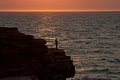
Broome, September 20th. There were several campsites in and around Broome, we chose Roebuck Bay Caravan Park and we were lucky to get in. Our pitch was wonderfully close to the small Town Beach and it was obvious why many of the visitors were settled in for the whole summer. Curiously for a west coast resort the campsite faces east but it does mean that one can watch the sunrise. For sunset freaks, nearby Ganthaume point is the place to head for.
Above, L-R Ganthaume Point, Ganthaume Point, early birds and sunrise from Town Beach, just yards from our camper. We visited the famous Cable Beach where the first Australian undersea telephone cable linked to Java. It was a huge expanse of white sand stretching for miles in either direction, it was however very hot and exposed and expensive parasol and lounger hire was much in demand. We pottered down to the sea and along for a km of so but we didn't stay.
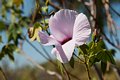
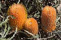
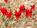
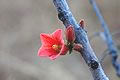
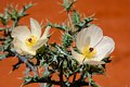
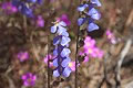
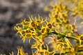
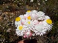
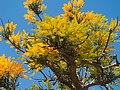
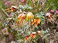
Above, just a very few of the flowering plants that we saw in Western Australia. L-R Native Cotton, Banksias, Mulla Mullas, Desert Pea.
Karijini National Park.
Between Broome and Port Hedland the Great Norther Highway runs for 600km through monotonous savannah. I had visualised it as Great Sandy Desert to our east sloping down to an endless turquoise sea in the west, but no, it was flat and hot with scattered, low trees in every direction. It would have been possible to break the journey at Eighty Mile Beach caravan park but we chose to press on to the mining town of Port Hedland which served the Pilbara region and home of Red Dog. The site, while clean and not unpleasant, was surrounded by industry and charged an exorbitant $15 extra for power. We'd would have dipped out on that one if it hadn't been so hot that we needed the air con in the camper.
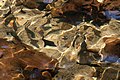
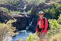
From Port Hedland we left the coast road and headed inland, keeping to the Great Northern Highway for 250km past Munjina Roadhouse where we turned right into Karijini National Park. The first 29km was surfaced but after that it was all on well corrugated dirt roads. The campsite at Dales Gorge was clean but basic, there wasn't even any water though convenient for exploring the Dales Gorge, Fortescue Falls and Fern Pool. The next day we transferred to the Eco Retreat Savannah Camp with the addition of water and showers. From here we explored the Hancock Gorge and waded through narrow and deep water sections to Kermits Pool. The temperature remained at a steady 35C hot, with clear skies but down in the gorges it was deliciously cool and there were several swimming areas. Above, L-R Fern Pool in Dales Gorge, Fern Pool with Water Nymphs, Dales Gorge from the lookout, Kermit's Pool Hancock Gorge, Hancock Gorge and sunset at Karijini.
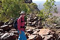
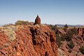
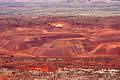
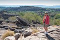
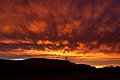
With the weather being so hot (for us) it was tempting to do very little during the day but we set our sights on climbing Mount Bruce (Punurrunha), the second highest mountain in Western Australia at 1235m. We got up at first light and after a quick breakfast headed down 35km of dusty unsurfaced road towards the Western park entrance, across Karijini Drive and up to the Mount Bruce car park and appreciation centre. The display board suggested a 6 hour return trip though we managed the 600m of ascent and descent in 4. Above, L-R looking back towards the car park; Marandoo View, about half way; the fine ridge beyond Marando; the summit cairn and a distant view of the iron ore mines for which the Pilbara region is world famous.
- Come gather 'round friends and I'll tell you a tale
- Of when the red iron pits ran a-plenty
- But the cardboard-filled windows and old men on the benches
- Tell you now that the whole town is empty
- Bob Dylan, North Country Blues
On returning, we drove to the neat little town of Tom Price which sits in the middle of nowhere, to stock up with fuel and groceries then west, through Paraburdoo and along the Wittenoom road in the direction of Exmouth and the Ningaloo Marine Park. Another long leg of about 500km but at the tip of the peninsula we chanced on the pleasant Lighthouse Caravan Park, close to the beaches and close to Exmouth. There was a campsite at Exmouth which we didn't investigate though it looked to be overshadowed by a military establishment and Yardy Homestead Caravan Park a little way down the peninsula and there were small basic camping areas down the length of the peninsula though there were all full.
Ningaloo Peninsula
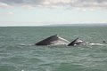
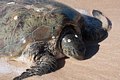
Ningaloo peninsula sports lots of excellent beaches and a coral reef that extends close to the shore in many places. We spent 4 days here, which was quite a lot for us but it didn't feel like too much. We went snorkelling, whale watching, gorge walking and turtle spotting over those 4 days and oh, did I mention lying on the beach. Turquoise bay was our favourite beach, the sea was crystal clear and the reef was only a few metres off-shore. Above, L-R, Map of Ningaloo; Sue emerging from the sea; Little corellas; beach life; Hump-back whales and Green turtle.
For some reason we decided to move on. Bad timing actually as the school holidays had just started and plan A was to visit Western Australia's favourite resort, Coral Bay. Sue rang ahead to Bayview Caravan Park and by some fluke they squeezed us in between two families each with 4 noisy kids. Still, we were out most of the day. Despite the crowded campsite, the beach had loads of space and we experienced some of our best snorkelling here. At times we were surrounded by fish of every size and colour dodging in and out of brightly coloured corals.
Eventually we cracked and moved out to the quiet little town of Carnarvon where Sue discovered the Marloo Retiree and Senior Tourist Park dedicated to the mature traveller. No kids, no noise, no crowds, drive through pitches, wow, an oasis of sanity in a sea of hysteria. Carnarvon acted as a base for two trips that we wanted to do, the first was the Quobba region on the barren coast to the north of Carnarvon, the second was to visit the Kennedy Range NP and then climb Mount Augustus NP several hundred km inland
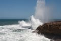
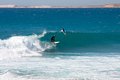
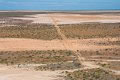
Above, Quobba. L-R we have the famous blowholes that explode into the air in response to huge Indian Ocean rollers, see also next picture; 4x4 only; Crocodile Dundee? and finally surfing off Red Bluff bay. The sealed road ends at Point Quobba but we carried on another 85km, driving along unsealed roads as far as Gnaraloo where there was an immaculate and almost deserted beach, This was a wonderful and uncrowded area and we spent 3 days exploring the area.
Back at Carnarvon, we stocked up with food and fuel and set off next day for the Kennedy Range NP. The first top of any significance was Gascoyne Junction 186km along the Carnarvon Mullewa road. There were extensive road works in progress when we arrived, the campsite was full of workmen and the fuel station did not open at weekends. Today was Saturday October 10th. Fingers crossed we headed up the unsealed Ullawarra road for 48km then turned off for another rough 12km to Kennedy Range NP. It was hot, 35C and this was our first experience of flies. They were just a bit of a nuisance and Sue dug out her mesh fly hat. There were several interesting gorges to explore, and one of them had a water hole at the end of it where dozens of Zebra finches were coming down to drink, see gallery.
Kennedy Range
Above, L-R Kennedy Range escarpments; KR gully; evening at KR, sunset over KR, Zebra Finches.
I did a quick back of a park pass calculation which suggested that we would have enough fuel to get to Cobra Bangemall station. The map showed a little symbol of a petrol pump but just in case, we decided to make an economy run which meant no air con, 2 wheel drive when possible and top speed off-road of 60km/h Next day we followed the Ullawarra road north for a further 145km to where it joined the Cobra Gifford Creek road and became narrower and rougher. Sue did much of the driving on this stretch but I could tell by the white of her knuckles that she was incommunicado. Eventually, with the fuel gauge still indicating 1/4 full we arrived at Cobra Bangemall Station where we were told that they hadn't sold fuel for many years and that we would have to carry on for another 56km the the Mount Augustus NP campsite. Perhaps it was a good job that we did the economy run. It did seem to work though, for instead of getting about 650km to a tank we got nearer 750km.
Mount Augustus, or Burringurrah to use its Aboriginal name is a large, asymmetrical anticline which rises some 715m out of the surrounding stony red plain. In a tale from The Dreaming a boy named Burringurrah fled from the rigours of an initiation ceremony but was pursued by his relatives and killed with a spear. Burringurrah died on his belly with his left leg bent up beside his body. You can see his final resting place when approaching Mount Augustus from the south.
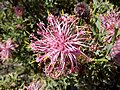
Hot though it was, we decided to climb Mount Augustus by the normal route from Flintstone-Beedoboondu car park. The suggested time for a return trip was 6 hours though we completed it in 4.5 hours. Flies really came into their own on this peak, we both wore fly hoods and were covered in the little insects. The walk was quite long (12km) but its 700m of ascent was easily achieved. Above, L-R unidentified desert roses and sunset behind Mount Augustus.
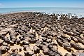
October 11th and once more back at Carnarvon we stocked up with food, filled up with fuel and booked in at our Senior's campsite. Next day we set off south again heading for Shark Bay and Monkey Mia on the Peron peninsula where Sue was keen to feed some dolphins, fat though they are already. It was 335km to Denham, the main town on the Peron peninsula so we broke the journey at Hamelin Pool Telegraph Station campsite, and then went to check out the stromatolites What? You may ask. Stromatolites were much more abundant on the planet in Precambrian times and they may have been largely responsible from changing its original reducing atmosphere to its present oxygen rich one during the first 3.5 billion years of life on earth. The stromatolites in Hamelin Pool were discovered by surveyors working for an oil exploration company in 1956 and were the first living examples of structures built by cyanobacteria. The cyanobacteria living in Hamelin Pool are direct descendants of the oldest form of photosynthetic life on earth. There were literally thousands of these strange growths stretching out into the hyper saline waters of Shark Bay. I tried striking up a conversation with these ancient creatures, thinking that they might have a lot to say, but apart from a few bubbles of oxygen I drew little response.
Above, L-R, Peron peninsula and Shark Bay map; The dusty road to Shark Bay; Desert flowers; Unidentified blue flowers despite them growing everywhere; Stromatolites from a distance and Stromatolites closer to.
Monkey Mia
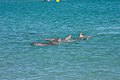
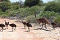
Although there was a campsite at Monkey Mia, we chose the Denham Seaside Tourist Village which is where we stayed for a couple of nights. Next day we travelled the 21km to Monkey Mia, getting there well before 8.30 when a pod of Bottle-nosed dolphins usually turn up for a snack. Above, L-R Waiting for the Dolphins; Dolphins arriving; Emu and brood.
We took a two hour trip on the Shotover catamaran, hoping to see whales, dugongs and dolphins. Wales no, Dugongs a brown smudge in the sea grass but dolphins a plenty, playing around the front of our boat. The tip of the Peron peninsula is a National park and though it can be accessed by 4x4 this is difficult terrain and we were advised to deflate our tyres to 20psi if we chose to go. A better way was to access the peninsula by boat. The adjacent Carang peninsulas and Dirk Hartog island were private and could only be accessed with permission along the Useless Loop road.
Kalbarri National Park
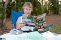
October 15th, the school holidays had all but finished and a eerie silence had descended upon the land. South bound again, and it was some 375km to our next port of call, the Kalbarri National Park. Further south now, the weather was cooler, the hillsides greener and there were a lot more wild flowers than in the more arid northern regions. We had hoped to join a half day canoe safari on the Murchison River which would include a breakfast stop, but with all the kids back in school there wasn't enough demand. Instead, we drove to the Kalbarri NP and set off on the 9km loop walk. Despite it being cool on the coast, the Murchison River area was hot and once again flies were a nuisance but the walk was one of the best. Above, L-R Kalbarri map; Murchison River; Start of our walk; Natures Window; Muchison River and the path lost and a grade 4 walk became a grade 5, and local resident, 15cm long. On another day we took a 16km there and back walk along the cliffs between Eagle Gorge to the Natural Bridge, see below picture 3, Despite it being semi-desert there were many flowers that we hadn't seen before. Below picture 4 Native Cotton (perhaps) and the amazing Yellow Tailflower.
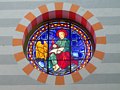
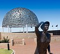
Geraldston is WA's second city though we were a bit underwhelmed by it. The cathedral was pleasant and though much more modest than any European cathedral it featured some excellent stained glass windows. The HMAS Sydney Memorial was probably the most striking feature of the city, and commemorated the loss of the HMAS Sydney in 1941 with the loss of all 645 men. It was a sad place, the dome featured 645 seagulls, one for each man. The bronze statue represented the women waiting for their men who never came home.
Our next stop was Jurien bay, about 220km south of Geraldston. This was a scenic route along the Indian Ocean Drive with the sea and dunes to our right and wild flowers and brightly coloured flowering trees all around. We deviated on our way to Jurien Bay to visit the intriguing Stockyard Gully cave, just another through trip. The final 10km of road was definite 4x4 territory with some deep sand and deeper dips. Flies came to torment us and fly hoods we de rigeur. Above, L-R 4x4; Cave entrance; Cave exit. A display board informed us that in the wet season the cave is completely submerged.
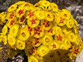
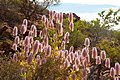
Above, just a few of the flowers that we found in the nearby Lesueur NP. Fragrant Waitzia, Australian Christmas Tree, Verticordia nobilis and Pixie mops.
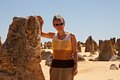
On our map, the Indian Ocean Drive only went just beyond the small town of Cervantes, beyond this to Lancelin it was unsurfaced. However, since our map was published the road men have been busy and there is a brand new smooth highway linking the two towns. For a visit to the The Pinnacles in Nambung NP however this information is irrelevant as this section was surfaced anyway. The pinnacles are an expanse of limestone monoliths that stretch from close to the sandy coastline to several km inland. Strangely, they weren't discovered until the 1960s and it may be that before then they were covered by drifting sand, dunes are common in this region. The mechanism of their formation is still a subject of some controversy and readers might want to check out the link here. However, how they were formed is almost irrelevant as they are just amazing. As far as the eye can see are pinnacles of various sizes and shapes, typically up to 2m high like sentinels from a bygone age. We wandered around here for some hours until the flies chased us into the visitor centre and then back to the camper. Above-L-R Sue with pinnacle; View of Pinnacles; Kangaroo paws and kangaroo with joey.
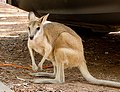
We were nearing Perth now. We pottered on down the coast, calling in at The Wedge, a sort of shanty town abutting a magnificent long beach, dropped in at Yanchep NP which was much like a conventional park and where we saw Koala bears, asleep in a tree top, and finished up at Quinns Rocks caravan park which was dramatically perched above dunes overlooking the sea. Next day we continued pottering and visited the John Forrest NP where we saw kangaroos, almost within touching distance.
This was our last night in the campervan. We stayed at the Midland Caravan park on the outskirts of Perth where we spent the afternoon cleaning layers of red dust from everything. Overnight we had torrential rain and over 30mm had fallen by the time we left for the Apollo depot.
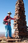
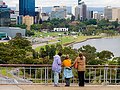
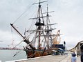
We stayed with my cousins for a couple of nights. Jill and Lynn came out with their parents back in the early seventies. They took us on a tour of Perth and Fremantle, which is the bit of Perth across the Swan River. Above, L-R Jill, Sue and Lynne viewing Perth from Kings Park; A replica of captain Cook's Endeavour.
Next day Jill and Lynn drove us to the airport and after thanks and farewells we were heading for the Qantas check-in desk. We were fortunate, Qantas was suffering from considerable industrial unrest and the day after we arrived home Qantas grounded all their planes. Close one that, Sheila
Summary.
Eight weeks travelling from Darwin to Perth, 9000km in all of which about 2000km were off road. Campervan was an Outback from Apollo, a new model and though it was advertised as 4 berth we thought it suitable no more than two adults and 2 small children. The base vehicle was a Mitsubishi Triton high clearance 4x4, automatic diesel with high and low ratio gears. The vehicle was very pleasant and comfortable to drive and returned about 26mpg or 11L/100km.
Campervan hire for 52 (50+2 free days for early booking) came to A$14876 (£9900) which worked out at A$286/day (£190/day) and included all bedding and crockery and cooking gas and drop-off fee. We took out some extra underbody insurance for A$199 which it turned out was a good buy as we quickly destroyed the pull-out step, a poorly designed low point behind a rear wheel
The habitation was equipped with air con which ran when power was connected although this failed some 5 weeks into the trip, and an electric fridge which would run on either mains or battery. The batteries would only power the fridge for about 12 hours (depending on ambient temperature and setting) and we found it necessary to supplement it with a cool box. Ice was available at most garages and even some remote locations and fully loaded it would keep the beer cold for about 48 hours.
One criticism we had with the equipment was the lack of any sort of basic tool kit. Clips and screws soon vibrated loose and were eventually lost on rough tracks and we had no way of tightening them. We also thought that the vehicle should also come equipped with a tow rope for rescue and rescuing.
Fuel costs depended on location,remote stations might charge well over A$2/litre whereas in a town it could be A$1.50/litre. Exchange rate on our trip was around A$1.55/UK£. We took out about A$1600 cash between us and used our credit cards in almost all locations without any problems. We did not need to use any ATM though they were common in most towns. Food was a somewhat more expensive than in the UK but apart from in Perth we cooked all our own meals.
Campsite prices varied considerably, ranging from £25/night with power in a well equipped site in a popular area to as little as £6/night in a basic bush camp. Facilities were always clean and even in remote sites the toilets were clean and non-smelly. Water was not always available in remote sites so it was important to stock up with large containers from the supermarket. Away from towns, water was often extracted from bore and contaminated by salt and other minerals making it only suitable for washing and cooking. It made terrible tea.
If you are anticipating visiting more than 4 National Parks it is worth obtaining a National Park Pass from the DEC (Department of Environment and Conservation) office for A$40, which lasts for 1 month.
Air travel with Qantas in super economy.