![]()
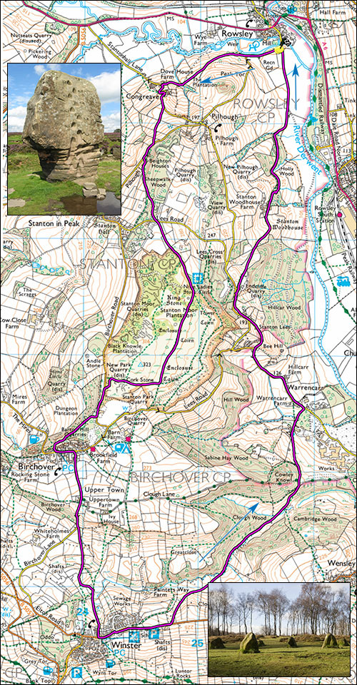
Peak Walk 12. Rowsley, Stanton Moor and Winster circuit.
- Map: The Peak District White Peak Area 1:25000, Outdoor Leisure 24
- Inset: Top The Cork Stone, Stanton Moor. below, The Nine Ladies Stone Circle.
- Time: Allow 4 hours
- Distance: 14km/9 miles
- Ascent: 433m
Off much of the tourist trail but none the worse for that. Start at Rowsley on the A6 southeast of Bakewell. There is parking just past the famous Cauldwell Mill, over the bridge and turn right at SK 257656. Parking at the mill is for visitors only.
From the parking, walk along the road to where it bends left, pass through the stile and follow a grassy track up the fields. After about 300m the path veers off to the right down to a small wood with Dove House farm behind. Pass through the farm and turn left up the steep little road. After about 200m after a second set of bends, the road becomes a little less steep and there is a stile on the right next to a gate. Pass through the stile and follow the path with increasing steepness to join another small road leading to Stanton in Peak. Turn right and after Beighton House take a narrow path on the left, steep at first then easing slightly as to turns to the right. When the path eventually becomes a gravel track, just past some huts and playing fields, turn sharp left up a path which zigzags up to Lees road, turn left on this and after a few metres take a prominent footpath on the right by a large boulder leading across the fields to Stanton moor. The Moor is steeped in history and contains stone circles, curious boulders and a mysterious tower. Check out the Nine Ladies.
Follow the main track over the moor though one can easily be side tracked by numerous interesting diversions. Heading left on the heather moor would bring one out at an ancient tower where one should turn right and follow the well-used path towards Birchover. At the south end of the moor, some 1.5km from Lees road the track branches. Following the left branch will soon bring one to a minor road where one should turn right. Following the finer right branch passes the easily climbed Cork Stone. Pass through a gate and turn left, this will bring eventually bring you out on another small road. Turn left.
Take the path below Birchover Stone's car park and follow this for about 300m to waymark pointing left to steps and a narrow path and steps which squeeze down between buildings to emerge near the Red Lion pub. Turn left, walk up the road for 150m, turn right by the chapel onto Uppertown Lane which says unsuitable for motor vehicles but has now been resurfaced, past Uppertown Farm where the road used to deteriorate. Turning left here would shortcut by about 1 hour and lead you to the Sabine Hay entrance. Go steeply downhill. Near the bottom of the hill cross a stile on the left and follow the fairly faint path across fields and shallow valleys towards Winster which should be clearly visible on the far hillside. Flagged steps have now been placed across some wet sections but there remains many traces of the original medaeval causeway leading to Winster. .
At Winster turn left and walk out of the village, past the school and car park, and then for a further 150m to a footpath sign and a stile on the left. The path is vague and intermittent but it crosses several fields heading for the bottom left corner where it meets Clough wood and a stream, stile and footbridge. Do not pass through the farmer's gate in the hedge row into the next fields. Cross a stile and follow the track by the river (can be muddy) until after about 500m one emerges into an open area of tracks and mine spoil. Note the limestone spoil in this gritstone area, a treasure trove of rare flowers.
Turn left and walk past the imposing edifice of what is left of Millclose lead and zinc mine. Follow the prominent track, past a substantial barrier, Keep left and pass through some gate posts marked Sabine Hay, continue for 200m or so to a sign on the right reading slippery steps. Take these ancient flags steeply down, past Enthoven's lead battery recycling plant and eventually to a minor road.
Turn left, level at first but gradually steepening to a road junction at Stanton Lees. Keep straight on for 400m and after the road dips there is a stile and footpath on the right. Follow this, undulating and vegetated at first then more easily down through Stanton Woodhouse farm on an excellent track, which after about 1.5km will bring you back to the starting point.
Points of interest: Ancient remains on Stanton Moor, Red Lion, Winster.