![]()
Peak Walks 13: Kinder Plateau Circuit
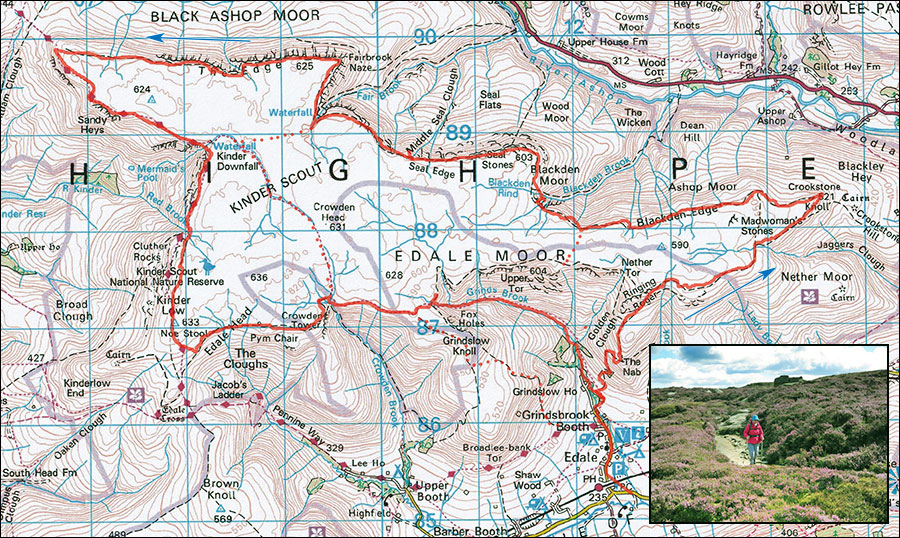
- Map: The Peak District Dark Peak Area 1:25000, Outdoor Leisure 1
- Time: Allow 8 hours.
- Distance: 27km (17miles)
- Ascent: 856m
- Inset: August on Kinder
A demanding full day out on one of the great Dark Peak walks. The ability to use a map and compass is recommended particularly if a short cut becomes necessary. All paths are well defined in good weather.
Start at Edale car PAD car park at SK125854. Walk through the village past the Nag's Head and follow the path northwards across the stream into Grindsbrook Clough. Don't follow the valley but instead take the ascending track on the right which zigzags up and leads in the direction of an outcropping of rock on the edge of the plateau known as Ringing Roger. The track levels then drops slightly towards a steeper eroded section. Ascend this or take the track on the left. Both eventually trend right and lead to the paved track along the south edge of the plateau after 330m of ascent. Turn right along the paved track.
Follow the track and path for the next 1.5km as it works its way round open moorland towards the east end of Kinderscout, traversing above Lady Booth Clough and Jaggers Clough. Keep to the escarpment edge, ignoring tempting tracks leading left. Eventually the track splits with the main right part heading down towards the distant Win hill. Keep left here and soon arrive at Crookstone Knoll where splendid views unfold towards the Snake Pass and Ashop Clough. The top photograph may have been taken from near here. Turn sharp left and keep working ones way west, keeping the Snake road down to ones right. When the path splits before a small white post, turn left uphill at a grassy break, at the next split head right on a minor path and eventually meet a larger, well used path which comes across the moor. Follow this rightwards working towards Blackden Clough., eventually passing an array of prominent boulders. Many variations exist.
Escape 1. Red Dots. 500m before Blackden Clough. by the boulders is an escape point and a possible shorter 4-5 hour outing. Head due south from here (left) up the easy moorland, occasional tracks, until things level out and the south edge escarpments come into view. This should take about 15 minutes, and on reaching the main track either turn left to return to Edale as one ascended, or turn right to Grindsbrook Clough. or better, the shapely Grindslow Knoll to return to Edale.
After crossing Blackden Clough. the path contours around the hillside and a further 2.5 km brings one to another deep Clough., Fair Brook. Cross the brook near the top and contour north (right) round Fair Brook Naze onto the rocky North Edge of Kinderscout.
Escape 2. Red Dots. From the head of Fair Brook, walk west or slightly south of west which after 1km of rough terrain will bring one to Kinder Downfall or its river.
Continue, dodging in and out of boulders and outcrops for a further 3km to where the escarpment abruptly swings southeast and where it meets the Pennine Way. Turn left and head south and east along the well-worn track for a further 2km to the impressive Kinder Downfall, a popular waterfall most spectacular in horrible weather when the water can be blown back in huge veils of spray..
Escape 3. Red Dots. This requires a compass. From above the Downfall, follow the KInder river for about 1 km, and where it swings left, stagger across bog and peat groughs for a further 1 km on a bearing of 140° magnetic (roughly southeast) which will bring one out on the south side of the plateau above Crowden or Grindsbrook cloughs. Heading down either of these but preferably Grindsbrook will lead to civilization.
From the Downfall follow the well defined Pennine Way south for some 2km. The track veres left then continues along the moor to almost the highest point of Kinderscout, Kinder Low 633m, rock and trig point. From here, continue south on the Pennine Way or southeast to cut the corner, for a further 1 km to the south edge of the plateau. Turn left. The path is part paved and leads through some intriguing rock scenery, the Wool Packs, Crowden Tower and Pym Chair and passes above Crowden Clough.
The track continues past Grindslow Knoll to Grindsbrook Clough. which leads straight back to Edale but there are pleasant variations if legs allow. Before reaching Grindslow Knoll, a new line of flags lead off right, avoiding the Knoll. As the flags end near a steepening, take the grassy track right alongside a row of fence posts, pass through a gate and when the path levels, branch left and keep left past old walls to a rough track leading down to Edale.
Alternatively, continue almost to Grindsbrook Clough. then strike out right to bag the small summit of Grindslow Knoll (601m) where there are stunning views in all directions. Cross the Knoll then head down and then left to pick up the rough track leading down to Edale.
Points of interest: Stunning views at every turn, Kinder Downfall, curious boulders.