![]()
Peak Walks 14: Five Edges Circuit
- Map: The Peak District White Peak Area 1:25000, Outdoor Leisure 24
- Time: 4.5 hours walking time.
- Length: 18km/11miles
- Height: Gain 430m
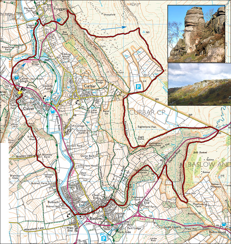
- Inset: Froggatt Pinnacle and Curbar Edge
A fine and varied walk with some stunning views but the woods above Baslow can be muddy after a wet spell.
Park at Calver Sough, either on the little one-way road near the traffic lights at SK238749 or in the village on the road next to the Derwentwater Arms at SK239748. From the traffic lights, follow the A625 which branches right towards Sheffield after 200m. Continue towards the bridge over the Derwent but some 100m before it, take the footpath on the left which leads through a small nature reserve, over a foot bridge and along the river bank for 600m to a road bridge. Join the road, turn right and right again at the junction and after 150m find a footpath on the left. The path rises up through a field (can be wet) to join the A625 below the Chequers Inn, cross the road (care) and follow the well marked footpath up through the woods. Pass through a gate and continue climbing up the hillside until one arrives at Froggat Edge.
Turn right below the crag and follow the path, past climbers onto the main, well-worn path along the top of the Edge. Follow this to the right for about 400m to the start of Curbar Edge where it splits before a small rise. Take the left branch and as the path begins to loop back right, take the more faint path left across the moors towards White Edge. The path can be boggy in places. Continuing straight on along Curbar Edge to Curbar Gap shortens the walk by about 2km and misses out on one of the best views in this part of The Peak. The path to White Edge is well marked but is not shown on my 1:25000 OS Map. At White Edge join a well used footpath and turn right; option to visit trig point at 365m. The path gradually loses height and after about 900m at a finger post turn right past the end of a wall to Curbar Gap where there is a PAD car park and sometimes an ice cream van.
Short cut: instead of crossing the moor the White Edge continue along Curbar Edge to the car park.
Turn right on the road and after a few metres take the track on the left which leads onto Baslow Edge. One can follow the bridleway past the Eagle Stone, once a challenge to any young man in Baslow wishing to get married, or trend right and follow the pleasant footpath pas a viewpoint abd along the top of the rocks with amazing views into the Derwent valley. The easiest ascent of the Eagle Stone is on the west end by traversing in from the left. About severe in standard.
At a T junction, turn left past Wellington's Monument (or straight on if you have walked along the Edge) and follow the track for about 1km to a minor road, turn right and cross the main Sheffield road to a gate at the corner with the notorious Clod Hall Lane, site of the infamous Carbon Copy murders in 1960. Pass through the gate and after the short flagged section take the fainter right branch to Gardom's Edge, continue pleasantly along to top of the edge for about 1km keeping the crag edge to ones right, passing through a gate, a ruined wall and a gateway until the path starts to lose height and joins a broad footpath. This is lovely countryside, grassy and dotted with boulders much like the tops of the other edges must have been in times past. Over to the left is Birchen Edge, inclusion would make 6 edges. Turn right on the footpath and follow it down to Sheffield road, cross this, CARE, and turn left along the footpath. After about 200m at a gate and waymarked stile turn right, go down the field and over a footbridge. Follow the left wall up the field for about 200m and after passing through a stand of tree enter Raddowhole Plantation on the left. Follow the well-marked path through the woods towards Baslow, pass some houses and on reaching a minor road turn left and down to the main A623. The path through the woods can be wet in places, there are some collapsed steps and an interesting rock slip to negotiate.
At the main road turn right, cross it to the church and take the narrow bridge over the Derwent to Bubnell alongside the Rutland Arms. Turn right and follow this pleasant minor road for 1.5 km up to Bramley Farm to where the steepening road turns sharp left. Opposite is a footpath, gained by an obvious ramp. Follow the path across meadows, taking note of the direction indicated by finger posts, to a stile in the top right side of the furthest field by a small wood. A less arduous variant is to take the footpath on the right before the hill starts to Bramley farm, cross the field and follow the Derwent to Calver bridge. Turn left and take the second left into Calver village.
Cross the stile and follow the path left and down (can be slippery in the wet) towards the village of Calver. The path crosses a shallow valley then up the field opposite. Maintain the same general direction past some very smart houses and at the road turnright down to the square. Bear right up Foldes Head past the Derwentwater Arms to Calver crossroads and your starting point.
Points of interest: Views, rocks.