![]()
Peak Walks 15: Hathersage and the Edges
- Map: OS 25000 OL24
- Time: 4.5 Hours
- Distance: 16km/10.9 miles
- Ascent: 850m
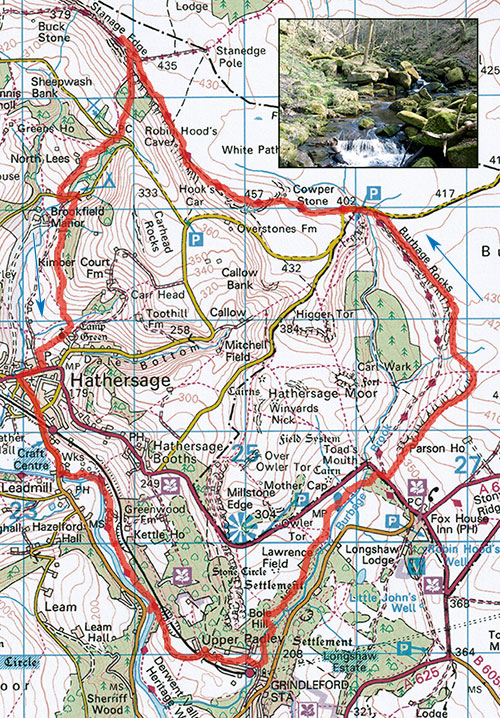
- Inset: Padley Gorge from the footbridge
Free parking can usually be found at Hathersage railway station approach, just outside of the village on the Grindleford road at SK232812. Turn left out of the station approach, pass under the railway bridge and walk along the road for about 500m to surfaced lane on the left signposted to Grindleford. Follow the lane past curious carvings and picnic places at Harper Lodge, dog right and continue through fields for about 800m to the NT Coppice wood. Pass through the gate and after 100m take the left branch up through the woods to a gate through a wall.
Pass through the gate and trend left over the railway bridge and up the rough pasture for about 200m to where it is possible to work ones way right onto a well used track. Follow this through Upper Padley, past an ancient chapel to a footpath on the left leading into Padley Gorge. Continuing straight on for a few minutes would bring one past Totley Tunnel to Padley Cafe.
Enter the gorge, paths wander all over but keep the river close to your left and after about 400m cross a wooden footbridge (easy to miss if one is not close to the river). Follow the zigzag track up the steep river bank, until, after passing a stone seat the path joins a wider track. Turn right onto this.
Follow the track through fine oak woodland until it bursts out onto a heather moor. Keep the stream to ones right, then cross it by a small bridge and follow the path to the main road. Turn right up the road to a well marked track on the left, this is Green Drive though it is a while since it was green. It is possible to follow this to Burbage Bridge but far finer to take a path less travelled by following the smaller track to the right of the start of Green Drive which soon branches left and passes through a gate. The path gradually gains height and traverses along of the top of the line of crags and old quarries that climbers know as Burbage South.
Eventually the path dips down to a cross path, continue straight across and up onto the top of the Burbage North crags and eventually to Burbage bridge. There are fine views of Higger Tor and Carls Wark across the valley to the left.
Follow the road left to the sharp bend then continue straight on along a footpath to Stanage Edge. The big boulder off to the right is the Cowper Stone. Climb up onto the edge and from the trig point continue along Stanage Edge for about 1.5 km. After passing Stanage Plantation (the woods below the edge) pass a small bridleway which joins from the right then quickly exits to the left down an ancient flagged path below a prominent boulder. If you arrive at the heavily used byway known locally as the Roman Road, you have gone too far.
Follow the pleasant flagged path steeply down towards the car park, and just short of it branch left to a small building at the side of the road. Take the footpath at the side of this, down past North Lees Hall, said to have been the inspiration for Thornfield Hall in Jane Eyre after Charlotte Bronte visited it while staying at the vicarage. Continue down to another small road, turn left and where the road bends left and starts to climb take the footpath on the right towards Hathersage. Pass by Cowclose farm and follow way markers that lead to the wet valley below Hathersage church. Unless you wish to visit the church, turn right before the footbridge and down the field to a well used track. Turn left into Hathersage, turn right down the main street and at the road junction turn left. After about 400m you will arrive at your starting point.
Points of interest: Padley Gorge, gritstone Edges, North Lees Hall.