![]()
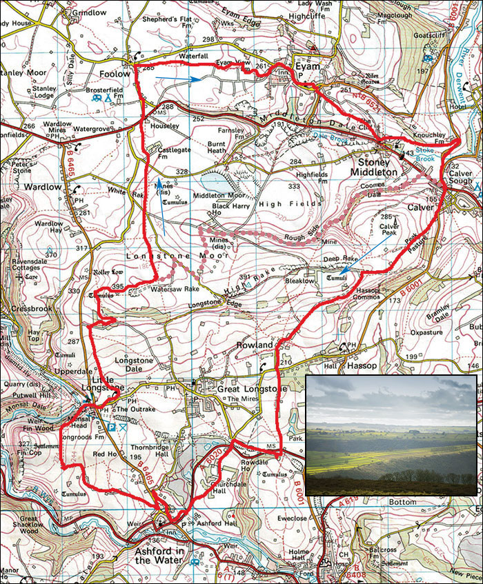
Peak Walks 17: Calver, Ashford, Monsal and Longstone Moor circuit
- Map: OS Outdoor Leisure 24, 1:25000
- Distance: 20/26km 12.5/16 miles
- Walking time: 5.5/6.5 hours.
- Total Ascent: 550m
Another fine and varied walk away from many of the honeypot areas, a full day out with some stunning views. Park at Calver Sough, either on the little one-way road near the traffic lights at SK238749 or in the village on the road behind the cafe at SK239748.
Walk past the garden centre at Calver in the direction of Bakewell, follow the road until the grass verge finishes then cross the stile on the right. Climb steeply at first then up a farm track which eventually levels out. Pass through the gate, turn right on a quarry track and after about 100m take the gate on the left. A new track crosses some recently graded soil leading to a gate. Pass through the gate and after a few metres, turn right. It's jungly for a short way but the path soon enters wide grassland. Contour the hillside, patallel with the minor road right, on a sometimes faint path which eventually drops down to a grassy lane. Follow the lane to the minor road and turn left down to the delightful hamlet of Rowland.
Follow the road through the village and at a road junction, cross over and take the footpath almost opposite. This follows a substantial limestone wall for about 800m, then drops down across fields to the A6020 near Toll Bar House. Dogleg left towards the house and take the path opposite across a field to the Monsal Trail on the disused railway line. Turn right along the trail for about 800m to where it is possible to leave it on the right at a bridge. Drop down to the road, pass under the old railway bridge and walk across the road junction to a footpath up a well made driveway. This leads past the very smart Churchdale farm and Churchdale house. After the house, the path cuts right over several stiles (note the direction of the finger post) and eventually emerges on the A6020.
Cross the road, turn left and after 400m, before the road junction take a small path on the right into Ashford in the Water. Follow this and at a road junction turn left then soon right on the the main road through the village. Follow the road past two pubs and a cafe to a widening near the church. One can cross this to view the river and ancient footbridge. However, keep to the road; it turns right and becomes Vicarage Lane and after a few metres take the footpath which doubles back sharply on the left. This squeezes between houses and allotments to an open field. Aim for the marker post and keep in the same direction to a stile leading into Pennyunk Lane. Turn left, (avoiding the private track on the left) and climb steadily up lanes (avoiding a downhill track on the right) to a field. Ascend the field. turn right at the top and follow well-marked paths to Monsal Head where there is a pub and Cafe.
Cross the main road and walk down into Little Longstone and just before the Packhorse Inn take the footpath on the left. Follow this into a field, cross the wall on the right and follow stiles, gates and waymarks up the gently steepening hillside for about 1.2km. The path becomes poorly defined but head for a shallow valley right of a blockhouse and a stile will eventually come into view on a projecting wall. Continue up field to a well-used track, Chertpit Lane. Turn right on the track and after 600m take a path on the left which double sharply back. Follow this pleasant greenway as it gently rises and curves to the right. Cross a stile and follow the wall on the right for 200m to a gate with a track coming up from the left. Pass through the gate and ascend to a rounded summit with a cairn and an ancient tumulus.
Walk down the pleasant green track for about 700m to a point where a path comes in from the right between two fenced enclosures containing collapses and which continues left to a heathery crest with an ancient rotting fingerpost. About 4 hours from start. Decision point, either:
Variation. -1.5 hours. Dotted line. Continue along the easy track for a further 300m; it eventually turns left (you can cut the corner) and leads to a minor road. Turn right on this and after about 500m take a footpath on the left past Longstone Moor farm. Cross fields and descend to a stile in the lower right corner. Behind are the notorious slurry ponds which burst their banks a few years ago, destroying the minor road below Cavendish Mill and coating Stoney Middleton with mud.
Cross the stile and trend left down to Black Harry Gate and into Coombs Dale. Take the well defined track down Coombs dale. In wet weather this can become a small stream. The track passes the disused Sallet Hole mine which also issues a stream. Continues losing height until the track becomes surfaced. In summer, the section between Sallet Hole mine and the surfaced track becomes a botanical paradise, with Woolly Thistles, Marjoram, Scabious and Knapweeds, and all the insects and butterflies that go with them. Continue down the track to the main A623, turn right to regain your starting point.
Else: At the cross paths turn left up to the remains of an ancient finger post on the hill top and continue in roughly the same direction for about 2.5 km to pass Housely House on the A623, crossing numerous stiles, two minor roads and a track on the way. Cross the road and follow the minor road towards Foolow for about 700m then take the footpath on the right which starts in someone's front garden and in 2.3 km leads to Eyam. The path was once known to us as the path of a thousand stiles, an slight exaggeration perhaps and many of the ancient stiles have been modernised to rickety wooden gates. Progress. The path crosses the dry valley of Linnen Dale and eventually passes down a ginnel, crosses a small field, then another ginnel through a housing estate into Eyam.
Turn right and walk through the village to the square at a road junction, cross and take Lydgate to Stoney Middleton. Footpath or Bridleway, the former is better and passes the Boundary Stone. In Stoney Middleton turn left, pass the rare octagonal church and the thermal spring and at the end of the surfaced road cross the stile on the right. Follow the footpath for 600m, keeping at river level to the B6001. Turn right to return to Calver.