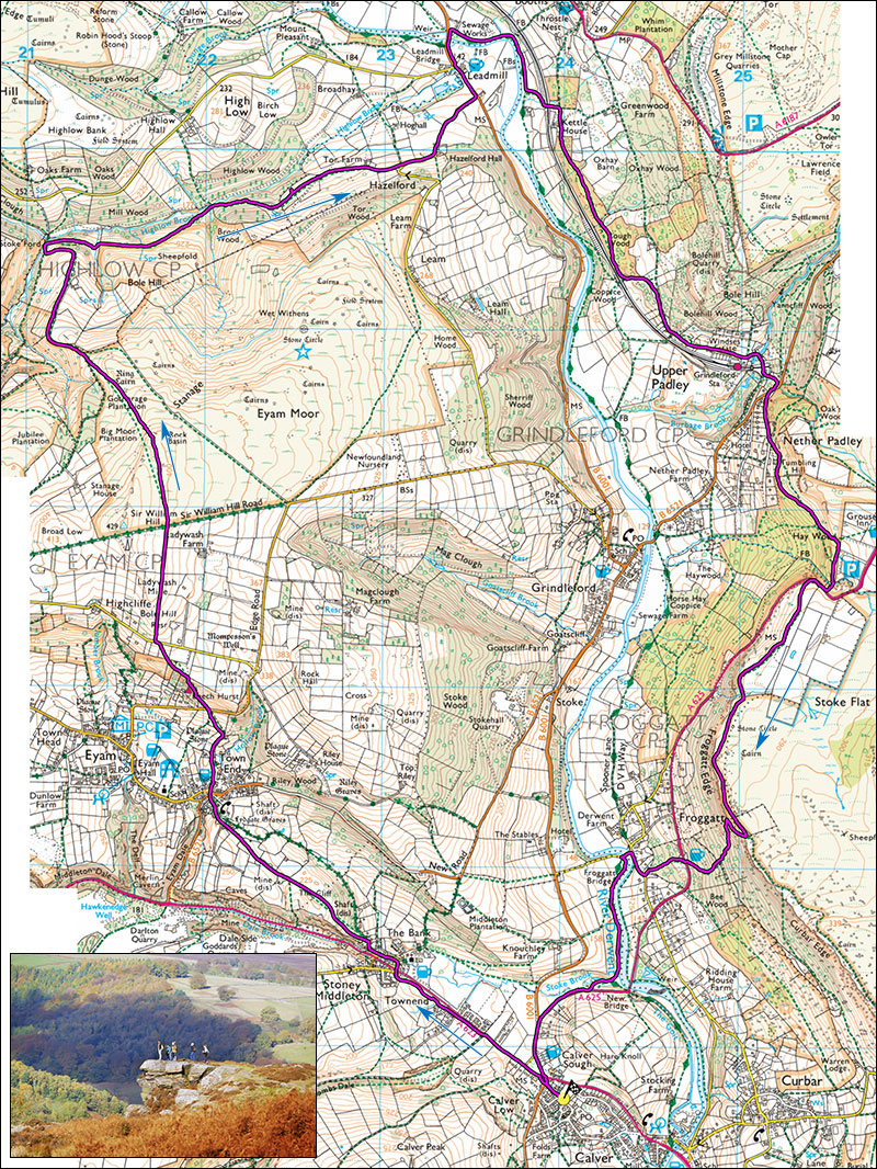
20. Calver, Eyam Moor and Froggatt Edge circuit.
- Map: OS 1:25000 OL24 + tiny bit of OL1
- Time: 5 Hours (4 Hours shortcut)
- Distance: 19km/12 miles (16km/10 miles)
- Ascent: 520m
- Inset: Froggatt Edge
A fine walk with super views and a fair amount of ascent. Inset, Froggatt pinnacle.
Start from the little one-way road at Calver cross roads SK237749. Parking is usually possible here, if not the road behind the cafe leading into Calver village is usually OK.
Walk up the main A623 towards Stoney Middleton for 300m, cross the road and take the footpath that starts from the playing fields, running parallel with the main road. Pass through The Moon Inn car park, cross the road end head into Stoney Middleton village. Where the road splits head up and left then right, past The Old Reading Room to where the road levels and becomes unsurfaced. Pass through the gate on the left and climb, steeply at first up the hillside, and eventually into a lane leading to the village of Eyam. Cross the road junction and take Water Lane alongside The Miner's Arms. The road steepens and ends at a seat. Pass through the gate on the left and follow the path up to a road. Alpacas are usually seen here.
Dogleg left, pass through a gate and follow the paved track through the woods to where it continues, unpaved and sometimes muddy up beside a wall, eventually topping out by fields where there are superb views down to the left of Eyam and the moors behind. Go left through a series of small gates to reach a minor road. Dogleg left and cross a stile, continue up the fields with gradually expanding views. Cross the next stile which leads to a broad unsurfaced track, Sir William Hill road. Cross the track and the stile opposite and follow the path across Eyam Moor to a cairn with amazing views. You have ascended 290m from the start. Continue down the escarpmant, maintaining the same direction, cross a stile in the lower corner of the field and take the pleasant green track down into Bretton Clough. At the stream, do not cross but remain on the right bank. The path climbs, then traverses then drops down to a rushy valley which is often muddy.
Cross the stream, cross the stile and climb steadily up the track which levels then drops down to Stoke Ford. Do not cross this but take the path through the plantation to pleasant fields, past a farm where it joins a minor road. Walk down the road past Highlow Hall to the main road. Turn left here, pass the Plough Inn, cross the river Derwent and after a few more metres enter a lane on the right. This leads to Harper Lees Farm.
Shortcut. Continue past Harper Lees and follow the river Derwent through a wood and across meadows to Grindleford. Cross the road and take the path opposite through woods and an ancient lane to Froggatt Village and the bridge. This will cut 1 hour off the circuit.
Just before Harper Lees, take the footpath on the left which climbs steadily and passes underneath the railway. At a crossing take the path on the right which passes above Kettle House and then enters pleasant deciduous Gorsey Bank Wood for about 1km. At the exit from the woods, turn left up the field, pass through a new gate then trend right to join a well-used lane leading to Upper Padley. Note the ancient chapel in the village. Cross the railway with a good view of the entrance to Totley Tunnel, pass or stop at the ever popular Padley café. Just after the café take the steep path up to the main B6521. Walk down the road a little way, cross it and enter Tedgness road. Follow the road to where it levels and take the second footpath on the left in the same general direction.
The path dips then rises gently, at a junction take the steeper path left to arrive near the NT car park and within striking distance of the excellent Grouse Inn. Keep right, the well-used path dips, crosses a stream then climbs up to the main A625. Turn right, cross the road and go through the gate which leads to the footpath along the top of Froggatt Edge. After about 600m, pass through another gate and continue along the pleasant sandy path. 100m past the rocky outcrops above Froggat Edge find a rocky track which leads down and doubles back below the crags. Follow this (climbers) to a view of Froggatt Pinnacle (inset) and take a steep track dropping off to the left. Steep at first but soon easing, cross a stile and soon reach the main road below the Chequers Inn.
Cross the road and take the path leading down to Froggatt village. This can be challengingly wet at times. On reaching a small road turn right, cross the bridge (see shortcut) on the left and gain the footpath running along the true right bank of the river Derwent. As one approaches the road bridge, take the right branch of the footpath to the A625. Turn right, at the junction turn left and reach your starting point.
