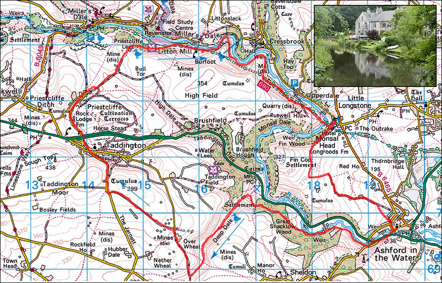
21. Ashford in the Water, Deepdale, Taddington and Miller's Dale circuit
- Map: OS 1:25000 OL24
- Time: Allow 6 hours
- Distance: 20km/12.5 miles
- Ascent: 580m
- Inset: Litton Mill, Water cum Jolly.
A great, long walk visiting deep valleys and high limestone upland. Start at Ashford in the Water at SK194696. There is usually parking to be found near the church.
From the car parking near the church, cross the footbridge over the Wye to the main A6, cross the road and turn right, After about 300m take a minor road on the left signposted Sheldon. After a further 200m, where the road turns uphill, take the footpath on the right. Follow the river Wye, keep left at an old watermill, pass a sough which is the old drain for Magpie Mine up on the hilltop. This sough has been blamed for the drying up of the Lathkill river in dry seasons and there are controversial plans to close it, thus flooding the lower reaches of the mine which is currently used for recreational purposes.
The path climbs through pleasant woodland then drops, crosses a gate and continues downhill. Where it meets another path, turn left into Deepdale. The dale is rough and can sport a stream after wet weather. After about 1km it opens out and becomes more grassy, and after another 250m it meets a wall. Pass through the gate and turn left, after a few more metres there is a signpost where paths cross. Continue up the valley to a lane, turn right into Over Wheal Lane, follow the lane past Over Wheal farm.
After 200m at a cross roads turn left and follow this broad bridleway over the limestone uplands for about 1km to join a minor road. Turn right, which leads into Taddington. In Taddington turn left up the hill, keep right at a junction and as one leaves the village take a small road (Horsemill Lane) right to the A6 dual Carriageway. Cross the road (Care) into the road opposite and follow this pleasant lane to Priestcliffe. After about 1km, the lane joins another one, continue then turn left (seat and sign for Miller's Dale), follow the farm track for about 500m and where the track bends left take the footpath straight on which drops down through fields and then through a gate into Derbyshire Wildlife Trust nature reserve. The Path descends steeply through woods and down numerous steps into the valley floor by the river Wye. Turn right and follow the path to join the Monsal Trail.
Turning left over the old railway bridge would take you to Miller's Dale station and toilets. Turn right and after about 400m there are options.
1. Continue along the Monsal trail to the Litton Tunnel entrance.
2. Turn left, descend and cross the footbridge into Miller's Dale at the excellent The Angler's Rest pub. Turn right and follow the minor road alongside the river, passing some impressive limestone scenery to Litton Mill. Cross back over the river to join the Monsal Trail and turn left to the Litton tunnel entrance.
It is also possible to continue down the beautiful valley of Water cum Jolly to Cressbrook Mill but the path at the lower end is sometimes flooded. If you make it through, turn right, cross the river by the weir and follow the path to the Monsal Trail at Cressbrook tunnel exit. This misses out the high level path.
Just before the entrance to Litton tunnel, take the path on the left. This is the start of the excellent high level path which traverses the hillside above Water cum Jolly. Warning, the path is easy but there are steep drop-off leading down over large crags. In icy conditions, those with small children and those a little unsteady on their feet are recommended to walk through Litton and Cressbrook tunnels which are illuminated.
Cross the stile and climb steeply up to some old mine entrances where there are spoil heaps of Fluorspar and calcite. Turn left and follow this delightful path as it contours the hillside. See picture. Eventually it drops down to join the path from Cressbrook Mill and then joins the Monsal Trail at the exit from Cressbrook tunnel. Turn left along the Monsal Trail, past an old station platform and after about 1km arrive at the Monsal Viaduct and the entrance to Headstone Tunnel. Turn left here and climb up towards the Monsal Head Hotel where there is a cafe and pub. Keep right at the top of the climb, along a footpath, which dips and then splits. Take the left branch which climbs steadily and runs along the rim of Monsal Dale.
After about 500m arrive at some seats, turn left here and follow waymarked paths along lanes and fields for a further 500m to where it turns left down fields to join Pennyunk Lane. Follow this, avoiding an early left turn and about 300m after a cottage and just after a private track on the right, cross a stile on the right and walk diagonally right across fields aiming for the right end of a block of houses. Take the narrow alley at the side of the houses down to the road. Turn right and keep straight on to return you to your starting point.
