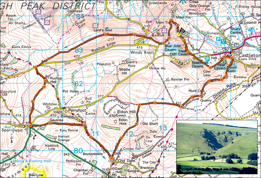
22. Castleton, Rushup Edge, Sparrowpit, and Cave Dale circuit.
- Maps: Outdoor Leisure 1 The Dark Peak 1:25000 and a tiny bit of Outdoor Leisure 24 The White Peak 1:25000.
- Distance: 19km, 12 miles
- Time: Allow 6 hours walking time
- Height Gained: 620m
- Inset: Winnats Pass
A circular walk starting near Castleton and covering some of the uplands between Rushup Edge and Bradwell moor. Above, some of the remains of the old Mam Tor road..
It is possible to park at the rather expensive P&D car park in Castleton, but cheaper to park free by driving past Treak Cliff cavern to the end of the old road below Mam Tor at SK134835 near the ancient Odin Mine. As the route is a circuit it matters little where one starts.
If starting from the PAD car park, exit the car park, turn right, cross Peakshole water then take a left towards Peak Cavern. At the T junction turn right up Goosehill. The road becomes a track, follow this to Speedwell Cavern car park below Winnats Pass, cross the road and continue towards Treak Cliff Cavern, drop down steps to the road, turn left and walk to the end of the driveable section, a further 400m.
Originally, this walk went up the track adjacent to Odin Mine, one of the oldest lead mines in Britain. However, the powers that be have decided that the path is dangerous and has been closed. So, walk up the ruins of the road that runs beneath Mam Tor and marvel at the damage that the continuous land slip has made to the old road. No wonder the engineers couldn't keep up with it. Pass the entrance to the Blue John Mine where there is a cafe and continue up the road to a footpath on the right. Follow the eroded track left towards a pine wood, cross the road below Mam Nick and continue onto the bridleway up Rushup Edge. Soon, the track splits, bikes left, walkers right. The path now rises gently to the rounded top of Rushup Edge 550m. You have ascended 271m from the end of the road.
The path eventually drops down to join Chapel gate, the track is often used by 4x4s and popular with mountain bikers. At the road take the fenced path on the right which will bring one out opposite a minor road leading down past Rushop Hall (sometimes cafe) towards Perryfoot. At Rushop Hall take the footpath on the right which leads over sometimes damp (wet) meadows to Sparrowpit, usually visible in the distance. The path can be vague so spot the stiles ahead. At Sparrowpit there is a welcome pub, The Wanted Inn, where most refreshments are available. .
From the pub, backtrack a little way down the B606 Castleton road and take a footpath on the right which leads via several stiles into a long stand of woodland. Walk parallet to the wall on the right, eventually the path drops down to a small road along Perry Dale. Turn right. After about 1km, turn left at Eldon Lane End Farm, this starts as a surfaced road but after a few hundred metres at Eldon Farm it becomes a grassy track. Keep climbing, the path eventually drops down to a gate, crosses a field and another gate to join a well-used track.
Turn right and follow the track for about 1km to a junction with several other tracks and a sign reading Limestone Way. Turn left through a gate, pass a sign pointing to Castleton an follow green tracks into an ever deepening valley which is Cave Dale. The track becomes stoney and after passing through a gate enter Cave Dale. The path is steep with loose stones and can sport a small stream which makes things slippery so take care. Eventually it opens out as it passes below Peveril Castle, then narrows before emerging at Castleton.
For those parked at the road end, turn left and keep left past an outdoor shop, a chip shop and a Blue John jewellers, over the stream, past the entrance path to Peak Cavern onto join Gooshill. Either turn right here to the P&D car park or continue straight on as in the first part of the description.
