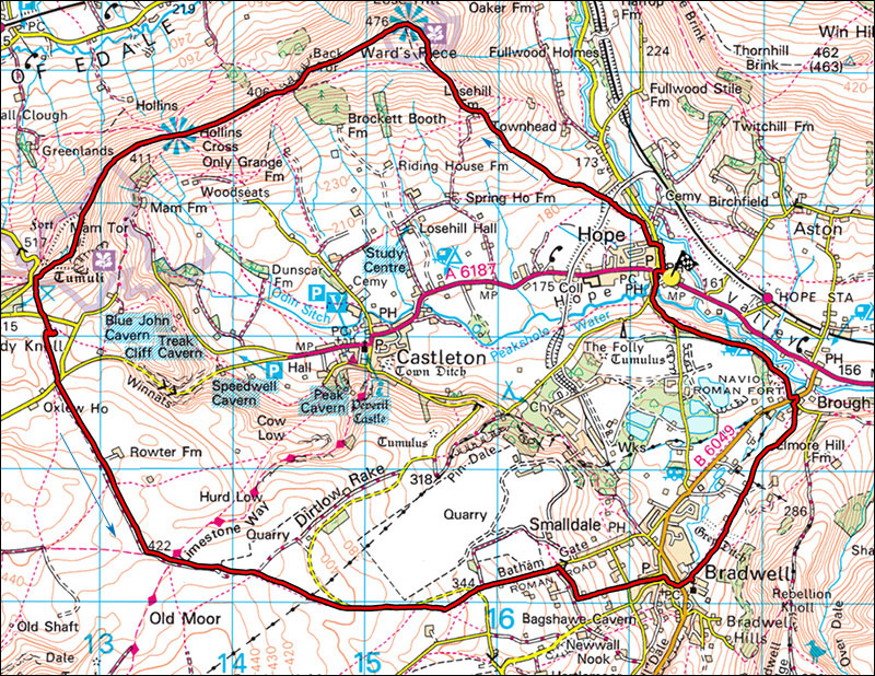
23. Hope Valley and Bradwell Circuit.
- Map: Outdoor Leisure 1 The Dark Peak 1:25000
- Distance: 18km 11miles
- Height Gained: 550m
- Time: Allow 5.5 hours walking time
Classic Hope, Lose Hill, Mam Tor, Bradwell moor and Bradwell circuit.
Start in Hope at SK173835. There is a P&D car park but it is often possible to get parked on the road for free. Take the footpath on the left before the Edale road, almost opposite the church, cross a local road and onto a footpath sign posted Lose Hill. Follow this through various gates and stiles, following way marks and yellow paint splashes. Keep walking uphill, past Losehill Farm from where the summit can be seen. Cross stiles on the right and ascend the flagged path to the summit of Lose Hill.
From Lose Hill (476m) where there is a panorama table, continue along the ridge which is paved in places, drop down past Back Tor and pass Hollins Cross. Stunning views, right is the Edale valley with Kinderscout behind, left is the Hope Valley, somewhat marred by the Pindale lime works. From here one can see Castleton, the dark gash of Peak Cavern, Winnats Pass, the ancient mine lead workings of Odin mine, and the creeping landslip below Mam Tor which eventually defeated the road engineers and caused the closure of the road. A visit to the old road remains can be quite an eye-opener. Eventually our path climbs up to the top of Mam Tor (515m) which is ringed by the remains of an ancient iron-age fort's defensive ditch though part of it has crumbled down the front face of Mam Tor over the long years.
Walk over Mam Tor and down steps to the road at Mam Nick, turn left, pass through a gate and continue straight down the field to the main road. This marks the boundary between the grits and shales of Mam Tor and the limestones to the south. Cross the road and follow a footpath past Windy Knoll (a small quarry) and a cave where archaeological remains have been found to another road, cross this into a lane beside a wall. The lane is surfaced as far as Rowtor Farm and then becomes a rough track. This is limestone upland, note the scars of ancient lead mining and natural sink holes. About 1km after Rowtor farm tbear left at a track junction, where our track crosses the Limestone Way. Ignore this and keep on along a wide track until after about 700m where the track bends left by an information board take a footpath on the right. Route finding on the next section can be moderately challenging.
Cross the stile and walk the faint footpath diagonally across the first field to a stile just left of a cattle trough. Cross the next field diagonally right to a narrow stile left of a gate which is some 100m right of the TLHC of the field. Follow the path alongside a stone wall which eventually runs parallel with a minor road, continue to a closing wall at another stile. Optionally or in wet weather, stride over the easy gate on the left to join the road and turn right down to a road junction. Otherwise cross the next stile and cross an area of tall grass which can be wet underfoot. Cross the next stile and enter a another field with shorter grass. Ignore the directional arrow and walk left, cross two stiles to arrive at the road junction. Turn left then immediately right down a narrow road.
The road steepens and after 500m at a sharp LH bend take the small road on the right. Follow this for 300m then turn left down a narrow footpath which eventually emerges at a road. Cross the road and continue down into Bradwell. At the next road near an old chapel turn right then left below The White Hart and continue downhill into the village, cross the next road (ice cream shop on the left) and follow the resurgeance stream down to the main B6049, cross this, and still following the stream continue for another 100m to a footpath on the right. Follow the footpath over numerous stiles and through gates for about 1.5 km to Brough.
Cross the main road and turn left, cross a footbridge then take the signed footpath on the right. Follow this for about 1km, keeping beside a line of trees, on approaching the end of the field head towards the right hand corner where it joins a minor road. Turn right down the road to return to Hope.
