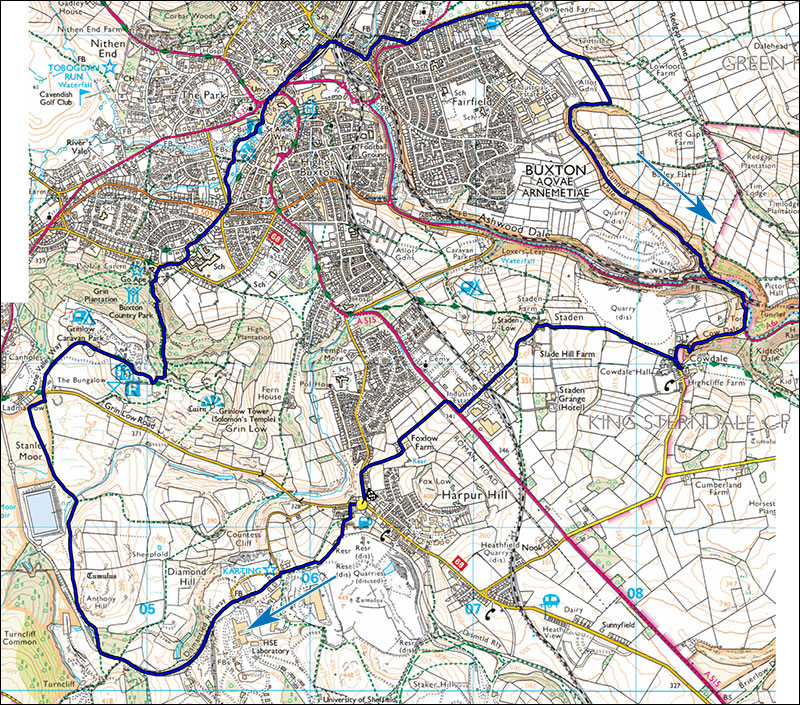
26. A voyage around Buxton.
- Map: Explorer OL24, 1:25000 The Peak District White Peak Area.
- Distance: 16.5 km (10.3miles)
- Time: 4.5 hours walking
- Ascent: 270m
Park in Harpur Hill on Grinlow Road at SK063712 where it splits west from Burlow Road/Harpur Hill Road junction. This is a walk with a difference taking in some of Buxton's surrounding scenery and the delightful town of Buxton itself.
Walk along Grinlow Road for 70m from the junction and turn left into Fiddle St. This climbs steeply, becomes a gravel track and eventually levels out below the old quarries of Harpur Hill. Turn right and follow a path into an industrial estate, cross the road and take the signposted footpath in the same direction. Follow this and the private surfaced road through HSE land for about 1km, pass a crossroads and continue to where the road is marked no admission; take the footpath down to the right through a wood.
The footpath passes several interesting sinkholes marking the junction between the limestone and the grits and shales of Axe Edge. The path climbs then drops down towards a reservoir, skirt a small wood and at a junction keep left past more sinkhole. The path eventually leads to Grinlow Road, cross this and take the road leading into the Caravan Club campsite and Grinlow car park. Follow the road into the car park, then take the path beside the toilets which climbs steadily, then at a path junction turn left and cross a stile. Your objective from here is Pooles cavern show cave which includes a car park and good cafe. There are many paths down through the woods but trending left and losing height will sooner or later bring you to the cavern car park.
Exit the cavern complex, cross the road and follow Temple Road down into Buxton. At a large intersection cross the road and enter Pavilion Gardens. Walk past the lake and down to the lower end of the park, exiting close to the stream, join the road and turn left past the Buxton Opera House, continue up the hill on Water Street, trend right past the impressive domed college and head for the railway station past the grand Palace Hotel. The station sports an impressive fan window which is now boarded up. To the left of this building is a narrow ginnel. Follow this past ancient sidings to a road, turn right and pass under three bridges to a junction, Take Nunsfield road by the garage which climbs up to the left. After about 200m take the narrow footpath on the right which leads steeply to the A6. Turn left on the A6, after the The Bull pub cross the road and after a further few metres take the minor Waterswallows Road on the right signposted to Wormhill.
Follow Waterswallows Road past the golf course and after about 600m where the footpath becomes a grass verge turn right down Lesser Lane towards Waterswallows Mews. Pass beside the Mews and follow the grassy lane through a small farm and eventually into a field. Cross the stile in the far right hand corner and follow the path down into Cunning Dale. Turn left and follow this pleasant dale down to the A6. In the summer months the dale is a botanists paradise with Melancholy Thistles, Rock Roses amd Globe flowes, to mention but a few.
Turn left and follow the busy A6 for 400m to a small road on the right leading to the hamlet of Cow Dale. The A6 requires care as it is busy and bendy. Stay on the left side of the road to avoid tight RH bends, and after passing under a bridge transfer to the RH side of the road when safe to do so. Walk up the minor road into Cow Dale and where the road dips take a signposted path on the right. This leads across fields to Staden, turn left and follow Staden Lane to the A515. Dogleg right, cross the road and follow the track up fields to Foxlow Farm, turn left through the farm and at the end pick up a lane on the right passing a white cottage. The lane leads to Harpur Hill Road. Turn left to return to ones starting point.
