![]()
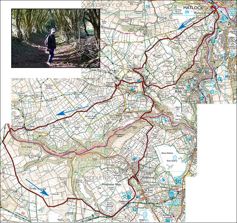
Peak Walks 28. Matlock, Ible, Middleton and back.
- Map: Ordnace Survey 25000 series OL24
- Distance: 21km/13 miles
- Time: Allow 6 hours.
- Ascent: 800m
- Inset: on the path to Bonsall.
An excellent and scenic walk well away from the honeypot areas of Matlock but none the worse for that. The first half follows the Limestone Way as far as the village of Ible before crossing the Via Gellia valley and heading off through Middleton and Bonsall.
Start in the PAD carpark next to Sainsbury superstore on the new Derwent Way ringroad at SK293603. Leave the carpark past the bus station and at the main road turn right up Snitterton Road, past ther tattoo parlour to find a sign pointing to the Limestone way. This heads steadily up hill and is generally well-signed with waymarks on the various stiles. At the summit, the path veers right, crosses a lane then a field and heads down pleasant lanes into the village of Bonsall. Turn left through the village, pass the cross and the King's Head and take the narrow stepped footpath on the right. Follow this to Upper Town. In Upper Town turn left down the hill past several attractive cottages and at the bottom take the signposted footpath straight ahead.
The footpath climbs steadily to fields and is not well-defined at this stage. Cross two hedgerows and shortly before a small barn cross the stile on the left and arrive a a small lane. Turn right up this and on entering a field keep by the fence line to a prominent sign post indicating limestone Way. Many of the fields show interesting signs of ancient lead mining. Take care not to lose the path as it dodges around various rakes and field edges, the Limestone Way waymark changes to a public footpath sign and passes to the right of Lay Farm and Whitestone Farm before eventually joining a minor road into Ible.
Turn right, ignore the first footpath on the left and turn down the next on the left just before The Beeches Farm. Follow this down to the road, cross this (care) and take the small footpath opposite. The path climbs steadily up to a track, turn left onto this and follow it for about 1.5 km to a large wind turbine where a vegetated path goes down left. Follow this, then across fields, ignoring a fenced stile down to the right. Eventually it is possible to drop down to Arm Lees Farm. Cross the road and walk past the cottage and through a tunnel under a disused railway. Cross the stile on the right and head up fields past the abandoned Moor Farm to join the High Peak Trail.
Option 1 From the HPT immediately turn right down a lane and at the road turn left and left again into Middleton. Walk up the road for about 700m to the second chapel.
Option 2 Turn right onto the HPT and follow it to Middleton Top,( bike hire and refreshments summer and weekends), climb the steps oppositer the cafe and turn right along an old incline, signpostt Middleton. At the top of the rise keep right along the top of an old quarry and cross a stile marked Private no admittance. Despite this the path is well-used, at a larger track dogleg right and cross another stile on the left and follow the narrow path down to a lane. Turn right down to the main road, turn left to the secont chapel in 200m.
Take the road on the right above the chapel for 400m and at a T-junction turn right. The road soon becomes a track, then a path. After a gate at the top of the woods turn immediately left and follow this sometimes rocky descent to a footbridge and the road. Cross the road and take the footpath a little to the left. At a fork turn right and follow this narrow path up through the woods for 250m to a small road. Turn right and at the junction turn left towards Bonsall. At the King's Head keep right and follow the lane, steeply at first for about 250m then take Ember Lane on the left.
Follow Ember Lane for about 600m, past Ember Farm and at the top of the woods pass through a small gate and follow the well-marked path down towards The Heights of Abraham. Drop down the hillside and take the descending path which eventually joins a small road. Follow this down into Matlock, turn left and follow the main road back to the bus station and carpark.