![]()
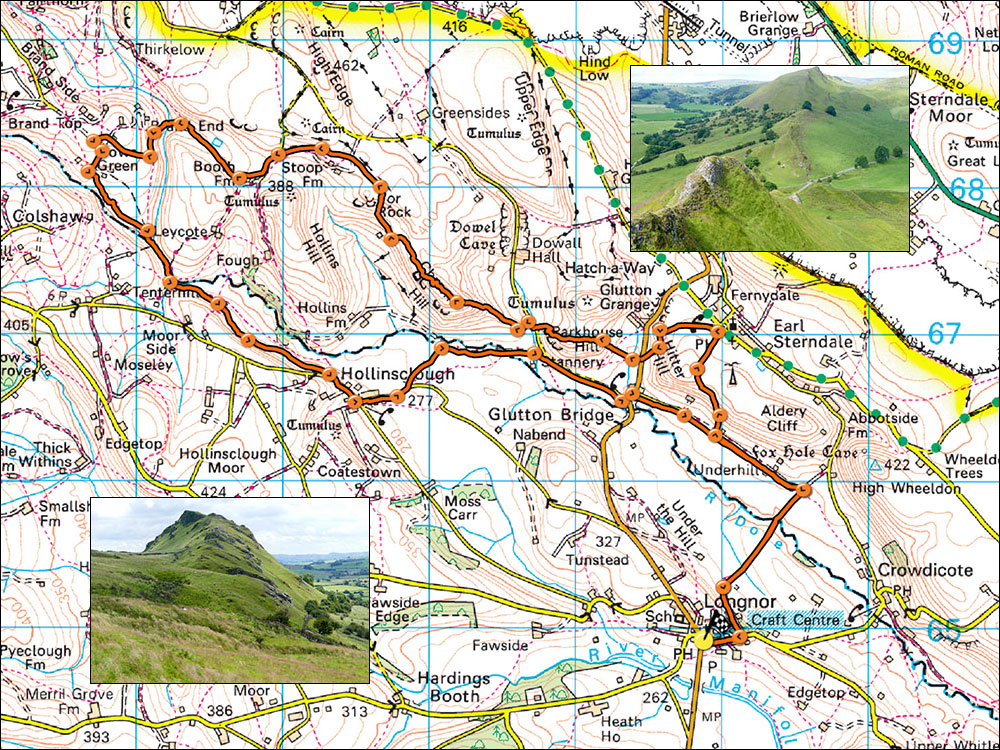
33. Longnor and the Reef Knolls
- Map: Explorer OL24 The Peak District
- Time: 6 hours
- Distance: 17.7 km/11 miles
- Ascent:720m
- Inset: Left: Parkhouse Hill, right: Chrome Hill.
An excellent but long and sometimes challenging walk through some delightful and unusual countryside, and after Chrome Hill is well off the beaten track. The Explorer OL24 is strongly recommended.
Start at Longnor village square SK088649 where there is usually parking to be found. Walk up the road towards Crowdicote for about 200m and turn left onto a lane called Top 'o th' Edge. Follow the lane then go right, down field and across the Dove at Beggar's Bridge to join a surfaced track. Turn left and pass through Underhill and after about 900m from joining the track take a footpath on the right signposted Earl Sterndale. Follow the path up the hill into the village and on arriving at the back of the Quiet Woman pub turn left and pass through several gates. The path continues down hill with Parkhouse Hill, prominent ahead, cross the minor road, take the gate opposite and wend your way up the west ridge of Parkhouse Hill (360m). In July, there may be stunning displays of Musk thistles here.
At the summit continue in the same direction, rocky in places, take care in wet weather as the rocks become very slippery. At a small col before the final part of the ridge take a small track to the right which traverses the north side of the hill, then turn left down to the road. This slight diversion from the direct descent avoids an unpleasantly eroded footpath.
Turn right and before a cattle grid pass through a gate on the left to begin the ascent of Chrome Hill (425m). The path traverses left a little way then ascends directly to the summit in two easy rises. Continue northwest along the summit ridge passing a curious hole on the right, drop right past a sheep's shelter cave then follow the easy path to where it drops steeply to the left. Continue down and pass through a gate on the right, follow the path to another gate, turn right and climb steeply up to a further gate. pass through this and continue to the track coming up from Stoops Farm.
Take the direction indicated on the signpost by the gate towards Booth Farm, just before the farm cross a stile on the right and follow the path down a valley containing a small lake. The valley marks a junction between the Carboniferous limestone on the right and the grits and shales on the left. After about 500m from Booth farm cross the stream and enter a deep lane leading up to Brand End Farm.Take the direction indicated on the signpost by the gate towards Booth Farm, just before the farm cross a stile on the right and follow the path down a valley containing a small lake. The valley marks a junction between the Carboniferous limestone on the right and the grits and shales on the left. After about 500m from Booth farm cross the stream and enter a deep lane leading up to Brand End Farm. Pass round the farm and at the top of the hill continue straight on along a footpath, passing a couple of delightful hay meadows, and at the edge of a steep decline follow the narrow path downhill.
Follow this steep little path which eventually crosses a small boggy stream and then joins an ancient cobbled lane. Follow the lane down and cross a fine little bridge over the River Dove. Cross a subsiduary stream/track to a stile and finger post marked Hollinsclough. This is a springline path and will require a little inginuity to avoid several boggy bits as it heads along the side of the valley. Things improve as the track nears Hollinsclough and at a minor road turn left into the village.
At Hollinsclough turn left and after 400m take the track on the left. At a junction the track swings right eventually joining a minor road below the flanks of Parkhouse Hill, this leads to the B5053 at Glutton Bridge. Turn left then after 100m turn right onto a lane which soon joins our earlier turn-off to Earl Sterndale. Reverse the rest of the route back to Longnor.