![]()
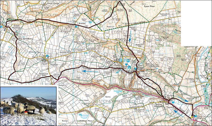
Peak Walks 4. Around Hucklow Edge.
- Map: The Peak District White Peak Area 1:25000, Outdoor Leisure 24
- Time: Allow 4.5 hours walking time.
- Distance: 19km/12 miles
- Ascent: 430m
- Inset: view from Hucklow Edge.
A slightly devious but excellent circuit that avoids many of the weekend crowds.
Park at Calver crossroads SK238749,there's a small one-way connecting road between the B6001 and the A623 that is often used for parking. Alternatively, parking can usually be found behind the cafe across the junction at SK239748. Turn west onto the A623 and walk towards Stoney Middleton. After about 200m cross the road to the football field then immediately right and keep on this side of the road to the Moon Inn at Stoney, then cross the road to The Nook and down into the old village. Walk for 100m then turn left at the junction, follow this up past some converted flats and continue uphill past the Old Reading Room then right to where the road levels and becomes a track. This can be followed to Eyam village but it's more pleasant to pass through the small gate on the left and climb the steep grassy hillside past the Boundary Stone and down The Lydgate into Eyam. The Boundary Stone marked the edge of the quarantine area of Eyam during the plague. Money which had been dipped in vinager was left in the small holes for food and supplies.
Walk left through the village, pass the school, the church, the sheep roast and at Eyam Hall cross the road pass the stocks and enter New Close on the left leading into a housing estate. Finger post to Foolow. At the T-junction follow a footpath straight ahead between houses, crossing roads until a field is reached. Cross the fields and turn left onto the lane. Follow the lane for about 2 km to where it joins a small road, turn right and after 250m take the road on the left, then almost immediately the footpath on the right. This leads past Brosterfield farm and cottages and where the road becomed gravel cross the stile on the left (easily missed). Turn right and maintain the same general direction for about 1 km to Stanley House. Turn right and follow the lane, keeping left at a junction where the path countours the side of Silly Dale. At a road, cross over (signpost Grindlow), at Grindlow follow the small road left, past a prominent sinkhole which takes a coinsiderable amount of water running off the gritstone of Hucklow Edge to a road junction, turn left into Great Hucklow.
Once in the village take the byway on the right opposite the old Chapel and after a 150m or so cross a stile on the right leading up through Great Hucklow Wood. Follow the path to a small road at the top of a wood on Hucklow Edge where there are soon fine views both left (gritstone Bretton Clough and Stanage Edge) and right (limestone Foolow, Wardlow and Longstone Edge). Following a mine collapse this small road and the hillside below it recently began to slip but it has now been repaired. Follow the road for 2km past two junctions and 500m after the Barrel Inn take an eroded lane on the left that leads towards Bretton Clough, signpost Stoke Ford. Keeping to the road would offer a short cut back to Eyam. Follow the lane, cross a track then and follow a well defined path over several stiles, alongside a wood to a stile where the path turns left, follow the descending path for 400m past a pine plantation almost to the enclosing wall. About 100m after the left turn it is possible to follow a narrow footpath right which cuts the off the corner. Superb views down into Bretton Clough. Before the enclosing gate and stile turn sharp right onto a small but well defined track towards a rocky escarpment on the edge of Eyam Moor marked as Stanage.
After the high point by a small post and cairn the ancient chimney of Ladywash mine will soon become visible. After another 500m, cross a rough lane and take the stile opposite and continue over fields past the mine to a small road. Turn left then shortly right at a finger post, cross fields past a wood and drop steeply down by a wall (can be muddy) then steps to a road. Dogleg left to a stile opposite then trend left across the fields past the farmers Llamas (alpacas actually) to Water Lane which emerges by the Miner's Arms. Cross the road and head for Stoney Middleton along The Lydgate, and at a junction take the bridleway on the left. At Stoney, either retrace your steps via The Moon Inn or turn left in the village, pass the Octagonal Church of St Martin and the thermal springs and where the road becomes a track continue straight on to the B6001. After a period of wet weather this section can become very muddy and reversing the route through The Moon carpark may be a better option. Turn right towards Calver.
Particular interest: Eyam village, Great Hucklow, Hucklow Edge, Eyam Moor, fantastic panoramas.