![]()
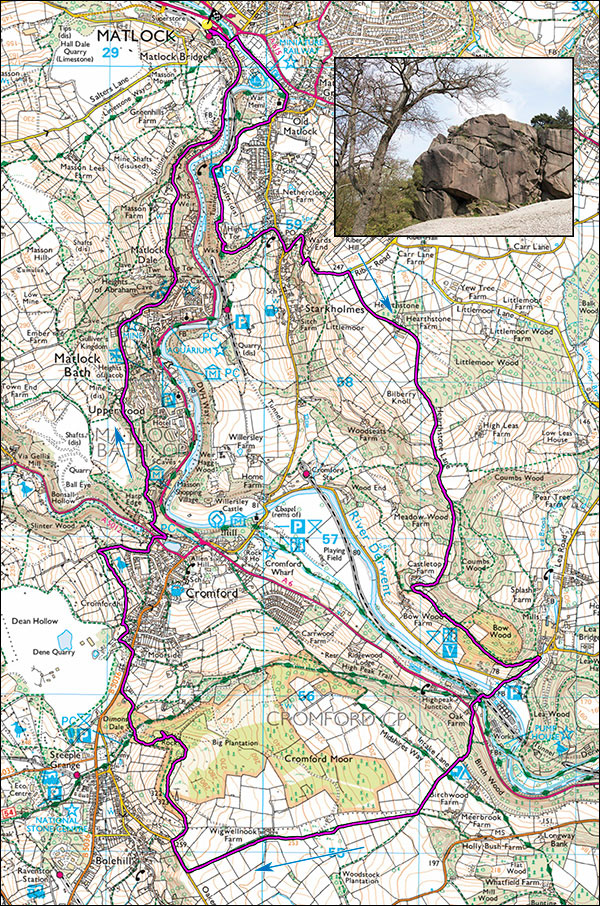
Peak Walks 5. Matlock, Lea Bridge, Cromford and Black Rocks circuit.
- Map: The Peak District White Peak Area 1:25000, Outdoor Leisure 24
- Time: Allow 6 hours.
- Inset: Black Rocks, Cromford
- Distance: 18km/11 miles.
- Ascent: 700m
This is a superb and varied walk, one of my favourites and away from the tourist trails, OK in any weather but particularly good in spring with the bluebells and new leaves. Look out for the rare Toothworts in the woods above Matlock Bath. Once there was a large free car park at Matlock station at SK296602 but a recent Sainsbury's development has made this into a PAD car park. From Darley Dale direction, turn right at the new roundabout and the car park is the next right after Sainsbury's.
Start, walk past the bus terminus and rejoin the main road, turn left over the bridge and then right into to the park on the left bank of the river. Walk alongside the river, continue past some rather stern Victorian houses to a steep road on the right. Go up this, turn right at the top, pass the church and after 50m find a lane on the right giving access to High Tor grounds. Follow the path steeply up (excellent views right) to where it divides near the top. Turn right, cross the mined out rift of Fern Cave and follow the steps towards the edge of High Tor. Those of a nervous disposition and those with uncontrollable children should stay well away from the edge. Turn left near the edge and follow the narrow path cut into the cliff with hand rail on the right, to steps and easier ground. Those choosing to avoid this rather exposed path should take the left alternative. Follow the steps down the hill, turn left past the end of Fern cave which is actually a mined out rift, to a point where a road on the left can be reached. Follow the road down to the village of Starkholms.
Turn right along the main road and after 100m take a very steep road (Riber Road) on the left which zigzags up the hillside. After a lot of steep road it suddenly levels out and after 50m take the track on the right to Hearthstone Farm. Pass through the farm and before the cattle grid, branch right up a concessionary bridleway, first up then down through delightful woods and open fields. Ignore any tempting signs or paths either side of the track. After several gates the track joins a steep surfaced lane, note the blue plaque to Alison Uttley, authoress of The Little Grey Rabbit and other books. Descend left for a few meters then at a sharp bend take a footpath on the left below Sunnyside house. This path crosses Bow wood (Bluebells in May), in the woods ignore a track on the left and eventually emerge at Lea Bridge, famous for its nearby gardens. Turn right down the road and after 200m on a bend take a footpath on the left past the sewage treatment plant, over the river, the railway and the canal to the little cafe at High Peak Junction. From here, following the canal rightwards towards Cromford offers a pleasant very short cut.
From the cafe, ignore the tempting railway incline which would also be a short cut the the High Peak Trail car park, but take the path leading up to the busy A6 on its left, cross this (care) to a stile on the left and follow the path up a field, into the woods taking the ancient, flagged right hand track, over a lane, past a campsite and then over fields crossing another lane on the way. The path is initially well waymarked but where you enter a large field and join a track coming in from the left, veer slightly right and walk up the centre and through a gap in a wall to a double gate, keeping the block of conifer woodland to your right. The track becomes overgrown and prickly and it is best to walk along the field to its left. Join a lane and continue in the same direction for about 1km, past Wigwellnook farm to Oakerthorpe Road. Turn right and after 150m, past a Bolehill sign and at a sharp bend before a bungalow take a steep narrow footpath on the right which soon leads to easier going across a meadow. Head for the woods, cross a stile and once in the woods go up and turn left, soon arriving at a white trig point. Right, in the woods is a sensitively positioned telephone mast! However, follow the blue markers down the hill, the many paths veers left and then right past Black Rocks to the car park on the High Peak trail. A small path exits the right side of the car park just over the wall, follow this, trending right past ancient spoil heaps to a track leading to the busy B5023. The limestone spoil heaps are home to some the small white springtime flowers known locally as leadworts. The limestone spoil comes from 128m deep mineshafts that once existed, driven through the overlying gritstone to the mineral bearing limestones beneath.
Turn right and after about 400m, past a large quarry entrance take the footpath on the left. Where it joins a road from the quarry turn right alongside a field and at the end of the field turn left to the zigzags leading up to the nature reserve of Rose End Meadow. Pass through the reserve where there are many rare flowers and after about 500m join a lane. Turn right and follow this down towards Cromford. After a row of houses take the well-surfaced path on the left, cross over the main road and take the narrow lane opposite. At the old Primitive Methodist Chapel take the steep cobbled footpath on the left.
The footpath zigzags right then left (sign post Matlock Bath) and traverses above some allotments to eventually join another track coming down from the right at an acute angle. Take this, the path now rounds the shoulder of the hill and traverses the hillside, with Masson Mill down to the right. Soon, the path climbs steeply, ignore diversions and eventually join a surfaced road between cottages. Follow the road for about 800m to where it starts to drop steeply. Pass the entrance gates to The Heights of Abraham, the road briefly narrows and a little further down on the left take the entrance to a path. This ascends, contours right, then rises, crosses a wooden bridge then joins a lane which then joins a small road that leads back to Matlock. At the A6, turn left and follow the road for 400m to the car park.
Particular interest: High Tor, Bow Woods, Cromford canal, Black Rocks, High Peak Trail, Masson Heights woods.