
The Faroe Islands
![]()
![]()
![]()
Three Days in the Faroe Islands with campervan, 25-28 July 2008, on route from Iceland to Scotland via Norway. Words and pictures, walking and camping spots. Links to other sites. Non-commercial.
What, you may ask, are doing in these remote islands set between Iceland and Norway for just 3 days? Well, you'd better ask Smyril line, our ferry from Iceland to Scrabster in Scotland, for whereas the ferry took us almost direct from Scrabster to Seythisfjorthur in Iceland, on its return trip it somehow felt obliged to drop us off in the Faroe Islands and visit Denmark. Three days later it returned but once back on board we were taken to Bergen in Norway before eventually docking in Scrabster to start the cycle over again. So, 18 hours out, 6 days back. Not all bad though because without this detour we probably would never have visited these delightful Islands.
The Faroe Islands are situated in the heart of the gulf stream, mid atlantic at 62° N. The Archipelago consists of 18 islands covering about 550 sq.miles and the highest mountain is 882m. They have a population of around 48 thousand.
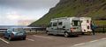
The ferry dropped us off at Torshaven, the main main town, on Straymoy which is the largest island. Streymoy and Eysturoy the adjacent island are joined by a bridge, Streymoy and Vagar are joined by an undersea tunnel, as are Esturoy and Bordoy. We drove into the town in thick fog and drizzle and though it was still quite early in the morning we managed to find a supermarket and a tourist office for some information and a sort of map. Then we drove north, undecided quite what to do. We gained height and the fog intensified and the drizzle turned to definite rain. Occasional through the streaming windows of the campervan we caught glimpses of mysterious fjords and craggy hillsides plunging steep into the water. As we progressed though, a strange thing happened, the mist thinned, the rain eased and then stopped and by the time we had arrived at Tjornuvik on the northern tip of Streymoy the sun began to break through.
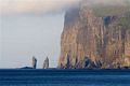

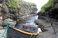
Left, Tjornuvik and the end of the road. Just short of the village there was a small car park, fresh water and a toilet block. We pulled in and admired the view. Out across the beach on the opposite headland were some monster sea cliffs that were rapidly appearing out of the mist and at their foot two prominent sea stacks. We later learned that legend had it that two Trolls conspired to tow away the island of Esturoy but undecided on who was to do what they were caught in the rays of the morning sun and turned to stone. Well yes. The next two pictures show the cliffs which we estimated to be about 350m. Mike and Chris Simpkins joined us and informed us that the tourist office had suggested to them that we camp here overnight for free and that the villagers would have no objections. Splendid, you don't get many campsites with a view like that.
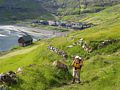
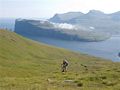
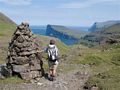
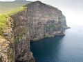
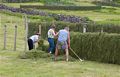
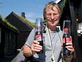
Next day the weather dawned perfect and Suzy and I went for a walk clutching our 1:200000 maplet that we had obtained from the tourist office. We took a waymarked path up the hillside which soon fizzled out then continued upwards past the very occasional cairn to the top of a stony ridge. The other side was something of an eye-opener, a deep uninhabited valley spread before us and on the other side were cliffs almost twice as high as those visible from the camper. The spot height on the map for the top of the cliffs was 564m or 1850 feet. We turned south and steadily gained height up a long ridge until it became possible to drop into the head of the valley that we hoped would lead us back to the valley behind the village. No thanks to our map it did and an excellent walk it was too.Left, leaving Tjornuvik, picture 2 gaining height, picture 3 a very big cliff, picture 4 home, picture 5 the villagers hay-making, picture 6 Suzy with refreshments from the tiny local shop and cafe. The villagers were all out, some in their best outfits to celebrate a wedding there.
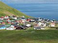
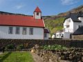
Next day the weather continued fine and settled and we took the campervan over the bridge to neighboring Esturoy and visited the beautiful little village of Gjogv, pronounced? No Idea.
Left, is the village harbour of Gjogv which is sited inside a deep little inlet,next, the village viewed from the hillside behind. It was a pleasant little place with various signs of celebration in preparation for the St.Olaf's day celebrations starting next day. We climbed the hillsides behind the village for some 400m or so and discovered yet more enormous cliffs, last, Suzy with refreshments from the tiny local shop and cafe. The villagers were all out, some in their best outfits to celebrate a wedding there.
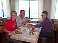
Last, drinks with Mike and Christine Simpkins in their camper.
Our map indicated a campsite at the village but we could find no trace of it and enquiries revealed that it was shut down years ago. Still, it couldn't have been any better than our spot in Tjornuvik and that was free.
Saturday we returned to Torshaven in increasing rain and fog to rejoin the good shop Narrona. We were informed by locals that it is not uncommon for one end of the island to be shrouded in fog whilst the other basks in sunshine. From Torshaven our ferry took us on a pleasant trip to Bergen in Norway before the final haul back to Scrabster.
Summary: An all to brief stop in what turned out to be some surprisingly beautiful islands. We though that we could easily spend a full week here under different circumstances. Walking maps, as in Iceland seemed unobtainable and it would seem prudent to obtain them before leaving the UK.