
Bergen, North Cape and Sweden by Campervan May-June 2004![]()
An account of an 8 week trip from Bergen to North cape by campervan May-June 2004, taking in the Lofoten islands. Return through Sweden, visiting Stockholm, lake Vattern and the island of Oland. Return over bridge at Orasund and through Belgium. Words, pictures and links. This combines the old Norway and Sweden pages into one.
chris and sue jackson email
This is our account of a holiday in the campervan from May 20th to July 21st 2004 that started at Bergen in Norway to North Cape via the Lofoten islands. This took us about four weeks.
From North Cape we dived down into Sweden and eventually crossed the Oresund bridge at Malmo into Denmark. Easy driving through Germany and Holland to Rotterdam led us back home. The holiday took 61 days and we covered 6300 miles. We used Fjord Line from Newcastle to Bergen and P&O Line from Rotterdam to Hull. This page covers Bergen to North Cape. See the Sweden page for the return journey.
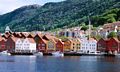
Above are views of Bergen. The pleasant harbour is full of boats, both fishing and pleasure, ringed by typical brightly painted old wooden houses. Behind the town are steeply woodedhills that can be reached by the town's funicular railway. Right, a distant view of Bergan.
For a little more detail, go to the About Bergen page.
It's a splendid town though the Norwegians call it a city, with lots of interesting shops, galleries, museums and restaurants. It also has an 'interesting' one way system to keep one amused. A bit like our city of Sheffield in that respect. From the top of the funicular it's possible to see most of the city and the archipelago of small rocky islets. We spent a couple of nights at Lone Camping, a delightful site a few miles outside of Bergen on the 580.
Bergen to Voss
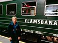
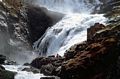
After a day exploring the town we set off along the route 7 and highway 13 to the ski resort of Voss, which, though not unpleasant is not at its best in the drizzle and without snow. Routes in Norway seem to be a combination of different bits of road and can be confusing at first. This section of route 7 included the road with no number along the side of the scenic Hardangerfjord, or it would have been, had it stopped raining. In Voss, on impulse we booked a trip on the 'Norway in a Nutshell' trip. This is a popular (though not in late May) circular excursion that takes all day. The first part of the rail journey is on the Oslo to Bergen railway. At Myrdal one changes trains to the Flamsbana (Flåmsbana). This famous non-rack railway zigzags 864m down into the Flam (Flåm) valley. The line took 20 years to construct and includes 20 tunnels, 18 of which were excavated by hand. The track is the steepest non rack railway in the world with and average incline of 1:18 (5.5%). Amazing, how did they dig steeply angled tunnels with hairpin bends in them? Picture left, just one of the many waterfalls. Click to notice the water Noeroyfjordnymph whose siren calls have lured many a nutsheller to his doom.
From Flom the next leg is a 2 hour boat trip along the Noeroyfjord (Noerøyfjord) which narrows down to 250m at one point. The fjord was lined with enormous waterfalls from the adjacent snow capped mountains rising to 1800m. After the first 5 stunning waterfalls we became quite blasé about them. At the end of the fjord was the small village of Gudvangen where we caught the bus back to Voss by the scenic route.
Voss to Geiranger
There were two options north from Voss, the E16 and then continuing on route 13 looked to be the pretty route, but continuing along the E16 meant that we would travel the world's longest road tunnel at 24.5 km (15miles). Not to be missed. Tunnels and ferries are a way of life in Norway, tunnels are generally free, ferries are not, so expect to pay £8-£12, more if you are over 6m long. So the tunnel it was and it took some 20 minutes to complete. Once out of the tunnel, the road veered north, we crossed the Ardalsfjorden by ferry and continued towards the immense sprawling glacier the Jostedalsbreen where it almost clips one of its arms. This was a beautiful area with tremendous views at every turn of the road; warm sun, blue sky and nobody there. Compare and contrast with the Rhone valley!
L-R Ardalsfjorden ferry, Jostedalsbreen glacier, Geiranger pass.
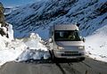
At Byrkjelo we left the E39 and followed the 15, gradually gaining altitude via a series of tunnels up to the snow line at about 950m. Here, a small road on the left led over a pass to Geiranger. The road had only just been opened but a recent snow slide meant that we could only just squeeze through. A couple of larger Hymers and a coach watched with interest but thought better of it and waited for the snow plough. Picture 3, that's us and the snow slide. Eventually the road descended by endless zigzags to the village of Geiranger and the perfect campsite at the head of the fjord. It was an idyllic spot, a bit touristy and I suspect quite busy in the high season. Large boats (QE2 on occasions) and tourist boats of day trippers made regular landfall at the pier. However, the sun kept shining and the site was 3/4 empty.
Geiranger to Andalsnes (Åndalsnes)
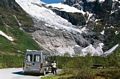
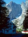
Almost endless zigzags lead out of the deep cleft of Geiranger Fjorden, over high and bleak terrain down to the ferry from Eidsdal to Linge. From Linge, we'd hoped to take the Trollstigen pass down to Andalsnes but we were a day too early and it wasn't open. Consequently, we had a long trip round the peninsula, pleasant but we would have preferred the pass. Andalsnes is a pleasant but undistinguished town of about 8000 inhabitants, its attraction for us was its proximity to the splendid Romsdal area of mountains. We camped south of the town at the pleasant campsite of Andalsnes Camping and Motel at a bend in the river. The weather just got better and better and we completed two quite long walks in the area. Above is Suzy with the Troll wall (Trollveggen), the highest vertical wall in Europe (1800m) in the background. Another good day out consisted of taking the campervan up the narrow toll road from Isfjorden to the car park at Venjedal whence it is an easy scramble up onto the ridge. From here there are amazing views of the Trollveggen and most of the Romsdalen valley all the way down to Andalsnes.
Andalsnes to Trondheim and the Grip trip
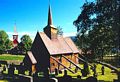
Still hot and sunny, we moved on in the campervan, taking a minor excursion to view a 13c stave church at Rodven (Rødven), for which Norway is justifiably famous, picture 1. Unfortunately it was only open for 6 weeks during the July and August so we couldn't look around the interior. Right, there it is. The name 'stave' does not refer to the props on the outside but its method of construction. The modern church is in the background.
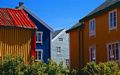
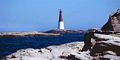
Back on the main 64 we took the ferry from Afarnes to Solsnes (Sølsnes) and then the Atlantic Highway via the small town of Bud, the locals told us that the highway was at its best when the waves were breaking over it. Even so it was splendid scenery with the little road linking lots of small islands, picture 2. We camped near Kristiansund and lured by pictures in the local tourist office booked for a trip to the island of Grip (pictures 3 and 4) some 14km from the coast. There are no permanent residents on the island, only holiday accommodation but people had lived there for many past centuries relying on fish for survival. Records in the 15C stave church on the island emphasize the hashness of living there and refer to many deaths and destruction of houses in great storms of 1796 and 1804. It's still a beautiful island with brightly painted houses and a famous lighthouse all set amongst 80 islets and skerries.
From Kristiansund it was necessary to backtrack for a few miles as it's on an island, and then join the E39 which with just one ferry hop from Kanestraum to Halsonaustan took us all the way to Trondheim. Well not quite, just a few miles short of Trondheim we took the 707 to Flakk and its wonderful campsite sloping gently down to the sea. A bus service from near the campsite allowed us to take a trip into the city and spend a day exploring. Particularly worth seeing were the cathedral, museum and art gallery. The waterside houses were also particularly attractive. On the E39 approaching Trondheim it's worth watching out for the toll points. Locals carry a pass in their car that gives them the green light. Tourists and strangers will probably need to make a manual payment. We're still anticipating a registered letter from the Trondheim authorities with a fine for non-payment!
Trondheim to the Lofoten Islands
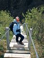
All good things must come to and end I suppose and the first clouds in 2 weeks began to build up on the day we planned to move north again. Donald and Christine, friends that we made at Flakk were setting off on a multi day trip on the Hurtigrute, the ferry that plies its way up and down the fjords. We took the very convenient car ferry next to the campsite from Flakk to Rorvik (Rørvik) and followed the 720 along the side of Beitstatfjorden until we met the E6 near Steinkjer. From here, we stuck to the major E6 in increasingly wet and windy weather until we struck a campsite at the small town of Mosjoen (Mosjøen) where, along with several other storm bound camper vans we battened down the hatches and spent the night. From Mosjoen we continued up the E6 for supplies at Mo i Rana then cut out west to route 17 which clips the serrated western coastline all the way up to Bodo (Bodø) inside the arctic circle. This is a classic and stunningly beautiful leg, the sun shone and everywhere were crags and mountains dropping down into Caribbean blue seas dotted with rocky islets. This section involved 2 ferries, the first between Kilboghamn and Joktvik was quite long and it was on the boat that we crossed the arctic circle. The second from Agskaret to Forøy took us to a campsite at the side of the Fjord. We did some more walking from near here, one circuit which started between two road tunnel entrances at the mouth of the Fykanvatnet lake included what must have been 1000 wooden steps zigzagging up cliffs to mountain huts on the alps above. picture 1.
Bodo (Bodø) (possibly pronounced booder) is the main sea port for setting off for the Lofoten islands, it also seemed to be the dental centre of the region with innumerable practitioners at every turn. This was fortuitous as I had developed an ulcer under a front tooth and had to have it removed. Gappy smiles from then on!
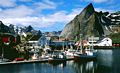
The car ferry to Moskenes on the Lofoten island took several hours and once disembarked we squeezed onto the rocky campsite at A (Å) at the end of the road. It may be a short name but we were never sure how to pronounce it. Pictures 2 and 3 are typical pictures of the villages along the east side of Lofoten, I think this might be Reine. The scenery was unbelievable and it was quite possible to use up a whole roll of film whilst barely moving the feet. Some of the southern Lofoten islands; Vaeroy and Rost (Værøy and Røst) have roads and habitation but Vedoya and Storfjellet are mainly inhabited by birds.
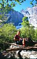
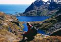
The weather remained settled and Suzy and I completed a couple of excellent walks starting from the camp site at Å. These involved exploring two of the valleys that ran inland from the coast. Picture 3 shows Suzy with the Djupfjorden down below after a walk past the lakes behind Sorvagen. The road crosses the narrow neck at the far end. The other walk was alongside the lake Agnatnet? from A and up to a col at around 400m with extensive views of mountains and sea in both directions. There are also a number of long distance footpaths on the island, privacy apart one can generally walk where one chooses, the going can be very rough however with deep vegetation and dwarf trees lower down, and steep terrain and rock higher up. Unsurprisingly, there is rock climbing to be had here.
Alpine type flowers grew almost down to sea level. Particularly common was the Dwarf Cornel Cornus suecica (picture 5), and Chickweed Wintergreen Trientalis europaea. We also found regular occurrence of Diapensia lapponica (picture 4) which is only known in one location in the UK.
Tromso to North Cape.
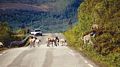
Onwards and upwards, well southwest actually, as its a 70km diversion to visit Tromso. At the small town of Nordkjosbotn we joined the E8 which heads into Finland and Sweden and the old faithful the E6 which was to take us towards North Cape. By now we were close to the top of Norway and our route to Alta, the next town was more like ENE. The scenery begins to change too and we crossed some vast expanses of tundra. Reindeer (picture 1) were frequently encountered wandering across the road, though elk remained elusive. The Sami people are indigenous to this area and they were regularly seen tending the reindeer or selling souvenirs at the roadside. We stayed at one of their campsites on the side of the Langfjorden, some 80km from Alta. A lovely spot, friendly people and excellent facilities. The fjord was beautiful, left is an evening shot some 100m from the campsite. While we were in the area we walked close to the snout of the Oksfjordjokelen (Øksfjordjøkelen) glacier which was close by. It's a pleasant walk but I'm not sure about claims that it's the only glacier calving directly into the sea. Most of the ice at sea level looked like debris. Still, a lovely place.
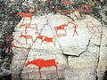
Next day we drove towards Alta in beautiful weather, so clear it felt like one could reach out and touch the mountains. Close to Alta at Hjemmeluft on a beautiful site overlooking the sea is a Unesco world heritage site containing 5000 year old rock carvings (picture 2). These were fascinating and appeared to tell stories or sagas about the people who lived here in that period. They almost certainly had religious significance too. Wooded walkways took the visitor around the most important carvings. For the most part they are detailed with brown paint to make them more visible. One of the sets definitely showed a space ship though Suzy reckoned it was a halibut. I also bought the obligatory tee shirt.
Pulling up the hill from Alta the trees thinned out to nothing and we didn't see many more until we entered Sweden on the way home. Everywhere was an endless brown moor occasionally broken by outcrops of ancient rock. At Nyland, we left the E6 to continue its relentless way to the Russian border and joined the E69, the road to North Cape. Rather than arrive at North Cape late afternoon we took the road to Havaysund and parked up for the night by the sea. This was June 20th and here we met our first mosquitoes. These were little more than a nuisance though I believe that in July and August they can be a problem.
Perfect weather again and the run along the east coast of the peninsula along Porsangen inlet was a delight at every turn, with sandy bays, cliffs and tunnels all above the bluest of blue seas. North cape is actually an island, not only that, it's not actually the most northern point of the island though it is possible to walk there. The most northerly point of mainland Europe is actually reserved for the nearby bleak and boggy peninsula of Nordkinn Halvoya which is just about joined to the mainland. Not many people know that. However, the downside of our objective was an expensive tunnel (£33 380Nok return) and a similarly expensive admission fee to the North Cape car park and the North Cape Hall complex. The only consolation was that we were allowed to park here overnight and come and go as we pleased for the next 2 days.
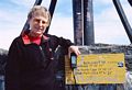
Like homing pigeons, the huge car park contained 50 or 60 campervans of all nationalities, many more plus a dozen huge coaches arrived as the clock crept towards midnight. Despite our best intentions we had arrived on midsummer's eve along with everyone else. The reason for the attraction remained elusive. The midnight sun had been shining on us since we crossed the arctic circle some weeks ago. Were there to be pagan rights performed? Were virgins to be defiled and flung over the cliffs? No, as midnight approached a cloud obligingly obscured the sun though and by 12.30 everyone was drifting back to there campervans and coaches. Picture 3, midnight at North Cape, midsummer's day 2004. Note the crowds and the North Cape globe. Picture 4, Suzy at North Cape clutching our GPS. You can't read the display but it says 71° 10' 18". Three seconds short, I blame the Americans.
Don't get me wrong, it's an atmospheric place surrounded by cliffs dropping hundreds of feet into the sea. The Hall is tastefully designed and the displays in the underground passages are quite interesting but from the cafes, restaurants, bars and souvenir shops it is obviously a commercial operation designed to make money.
Having run out of road in this direction, we turned south through end;ess birch forests, briefly crossing a bit of Finland and into Sweden.
June/July 2004 The Voyage Home from North Cape We headed back through the tunnel, along the coast ofPorsangen inlet to rejoin the E6 which we followed as far as the small town of Karasjok. From here we turned onto route 92 across 93km of tundra to join route 93 south leaving Norway and crossing into Finland. The scenery was almost intimidating, as far as the eye could see in every direction there were small trees, rocky humps and swamp, and this continued for the next several hundred miles. The only change was that the trees grew larger as we moved south. There was very little habitation and we seldom saw another vehicle.
North Cape to Lulea
This was the view from the campervan window on the road between Karasjok and Kautokeino on route 93. We crossed the border into Finland at Kivijarvi and crossed again at into Sweden at Kaaresuvantu, continued south through Vittangi, Maimberget, Jokkmokk and Boden and, apart from the built up areas there were well, a lot of trees. Boden is a military town, pleasant enough some 28km from Lulea on the Gulf of Bothnia where we stopped for a couple of nights. From here we drove south to the pleasant town of Umea for a couple of days.
e left Umea and continued south through Ornkoldsvik (Örnsköldsvik) to our first real objective was the High Coast of the Skuleskogen National Park. The National Park is a World Heritage site reserved for its natural beauty and geographical uniqueness. During the last ice age a vast glacier, estimated to be 3km thick covered this part of Scandinavia. The weight of ice has been estimated to have pushed the earth's crust 800m below its present level. When the ice began to melt 20,000 years ago the pressure eased and the land began to uplift. The shore line after the last ice age is now 286m above sea level and is continuing to rise at about 8mm per year. Hence the coastline is known as the Hoga Kusten, the High Coast. A nearby rocky mountain known as Skuleberget 295m contains the most elevated sea cliff in the world near its summit, reached by scrambly path or chair lift. The summit features a restaurant and exhibition centre but no boutique and swinging hot spot (Joni Mitchell).
Along the coast is a long distance walking path, served by several sleeping huts. Suzy and I completed a couple of sections of the path which crossed some beautiful countryside with lakes, ravines and boulder fields that were once shore lines. Much of the park is densely wooded however and views are only possible at sea or lakesides and on rocky prominences. 02, dinnertime on the end of a rocky peninsula, with typical High Coast scenery behind.
Stockholm
I'm not normally much of a city person, Suzy probably more so than me, but Stockholm, is a super place and I could easily have spent 4 or 5 days exploring it, rather than the 2 days that we had allowed ourselves. See about Stockholm page for more information. We stayed in the campervan at Bredang Camping (bredangcamping@telia.com) close to the wooded shores of Lake Malaren and some 500m from the train station. There are several concessional cards available to the tourist but the Stockholm card though initially quite expensive proved to be the best value for money. (48h 390kr), about £33 each from the campsite, giving access to 75 museums and attractions, free travel by public transport, free sightseeing boat trip, reduced water taxi fare and free parking.
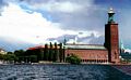
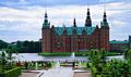
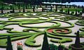
Picture 1 shows Stockholm's City Hall, taken through a boat window, hence the strange reflections in the sky. Looking at the sky, I'd say that this was taken on our trip to Drottningholm Palace, just another World Heritage site. Picture 2 Drottningholm palace, 3, Old Town Gamla Stan, 4, a racing bile and 5, the Vasa.
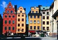
The palace was began in 1662 after the first palace on this site burned down. This palace was commissioned by the dowager Queen Hedvig Eleonora. Since 1981 Drottningholm Palace has been the home of the Swedish royal family. Three, just approaching it, the palace beneath a glowering sky. Rain didn't start for an hour or so but lightning kept striking down. We wandered around the splendid interior then visited the Chinese pavilion, a magnificent little creation built by King Adolf Fredrik as a surprise present for his wife Lovisa Ulrika's birthday in 1753 before dashing back to the boat before an imminent downpour. There were other things to see but the weather thought otherwise. A visit would not be complete without a visit to the Old Town Gamla Stan. Here, 17th and 18th century buildings crown above delightful squares and alleyways. Five, a Mozart recital is due to begin.
No description of Stockholm would be complete without reference to the bikes. Most people have one and I can only surmise that they stopped making them in the 1930s'. Six, a fairly racy little number circa 1925, Sprite bottle in pannier.
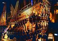
An essential visit (one of the many) is the Vasa museum located on the island of Djurgarden reached by water taxi. The Vasa, pride of the Swedish fleet sank on her maiden voyage in 1628. Design faults, a result of the designer's inexperience with such a large ship, caused her to heel over in the first squall, take in water through the gun ports and sink with the loss of 55 crew. In 1961 she was salvaged and has been restored complete with rigging in an immense three story exhibition centre. This was excellent, the ship was magnificent and the story of its recovery from the sea bed fascinating. This is a must. In one area, there was a chance to redesign the ship using a computer program. Confident, I reduced the width of the hull, increased ballast, relocated the gun ports and pressed the launch button. It sank. Seven, a 3.5 second exposure of the Vasa with the camera balanced on a banister rail.
Not far from the Vasa museum is Grona Lunds Tivoli with lots of scary rides and behind that there is Skansen. Skansen is the world's first open-air museum, first opened in 1891. Since then it has grown to 300,000 sq.m. It's enormous, a map is needed to find ones way back. It's pretty attractive to most adults but probably irresistable to children of all ages. Amongst other attractions it contains historic houses and farmsteads, folk dancing, animals (an elk at last), crafts and design, restaurants and cafes. Atendants are all dressed in traditional clothing and speak good English.
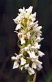
Orchids
Stockholm to Lake Vattern
Suzie birthday July 5th. We headed out of Stockholm on the E4 towards the country's second largest lake, Lake Vattern for a bit of rural solitude. Eventually we reached the small town of Motaka on the north eastern shores of the lake. It's a pleasant little place with a busy marina and an excellent car museum that contains a lot more than cars. If you're a 50s' and 60s' fan don't miss this one, it's excellent. After an exploratory afternoon we pottered dorn the coast to an excellent overnight parking spot on the coast near a marble quarry at Borghamm, (picture 1).
Next day we visited the moated castle at Vadstena, and more interestingly the nearby abbey church of St. Birgitta. The church was consecrated in 1430. The town is steeped in history and there is a Brigittine Nunnery next to the church It's a wonderful old church and many of the catholic statues remain even after its Lutherian conversion, though their hands have been removed in order to dispel their power. see 2. For a faith that didn't believe in them this seems a little strange.
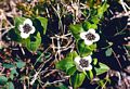
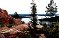
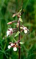
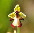
South of our parking spot at Borghamm is the Omberg nature park. It was an attractive area with steep forest and cliffs on the west side and gentle slopes nature reserves on the east. Suzy had a field day with the reserves and we say lots of orchids that would be regarded as very rare in the UK.
4-6 we have (I think) Broad Leaved Helleborine Epipactis helleborine, Early Marsh orchid Dactylorhiza ochroleuca, Fly Orchid Ophrys insectifera and Suzy in flower drawing mood.
A few miles away was the Rok-Stone (Rök-stone), the largest collections of runes of the Viking period found in Sweden. The Rok-stone is 2.5m high and is covered with 700 runes. The writing has been referred as the country''s first poem. In the poem, Varin alludes to heroic epics, myths and events that were familiar in the 9th century. Some are difficult to understand and there is a fragment of a poem by Theodor the Great. The conclusion remains unclear and many have tried to solve the riddle of the Rok-stone.
- The diarist
- Oland
- Avocet
Lake Vattern to Oland
Oland? Well, it's that long thin island off the south east coast some 120km by 15km, joined to the mainland town of Kalmar by a 6km long bridge. I guess that one of the reasons that we went there was that no one else here seemed to have even heard of it. We drove down the east side of lake Vattern to Jonkoping then almost south to Vaxjo then east to the bridge at Kalmar. The island is well, long and thin with a low profile but it turned out to be packed with interest.
From the mid 16c until 1801 Oland was declared a Royal hunting ground with scant regard for its inhabitants. Things were always bad but got worse with repeated Danish attacks on the island in the early 17c and the a series of disastrous harvests in the 19c. Eventually the farmers had had enough and a quarter of the population packed their bags and headed for the US of A. In 1970, the poulation was down to 20,000.
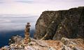
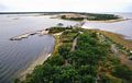
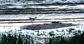
It's an island of unspoiled beaches, mysterious forests, pretty meadows and wooden cottages and has long been drawing the Swedes there. The islands attractions include numerous ruined castles, Bronze and Iron age burial cairns, runic stones old wooden windmills and forts set amongst some varied fauna and flora and some striking geography. To the south are barren limestone plains known as Alvaret. At either end of the island are lighthouses, fifteen is a view looking south from the northern one, Lange Eric. We stayed in a pleasant site Wikegards camping, some 35km north of Borgholm the capital. Next day we explored the south end of the island which is rather more barren and visited the lighthouse at the southern tip, Olands Sodra Odde complete with its 194 steps. The weather was beginning to crack up and next day was decidedly gloomy. Sixteen are some standing stones with a windmill in the distance. It wasn't all gloom and despondency though, and we spotted an Avocet just behind our campsite. It's slightly fuzzy as there's a howling gale, the camera lens is set at 300mm and Suzy, my mobile camera support was wobbling with excitement. Since then of course, in Norfolk back in the UK we've seen dozens of these birds.
Above, L-R Sue in camper, Oland, Standing stones, Avocet.
Oland to the Oresund Bridge
- Oresund Bridge
- Oresund Bridge
- Tivoli Gardens
- Tivoli Gardens
- Little mermain, Copenhagen
The weather became grey and wet as we made our way along the south coast to Malmo and the Oresund bridge. Had the sun been shining this would have been pleasant countryside, even so, we managed to visit a cider factory and a huge magalithic tomb on the way.
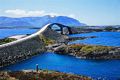
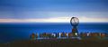
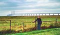
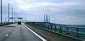
Picture above is the 16km Oresund (Öresund) bridge which links to Copenhagen in Denmark. Its a remarkable construction, part of it is a tunnel to allow the passage of large ships I suppose. Suzy tookthis through the campervan winsdcreen.
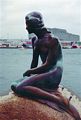
So that was it. Copenhagen was nice but busy and not as attractive as Stockholm. We visited some magnificent castles in Denmark (Helsinor, Fridricksbourg, crossed into Germany - now I know where Heligoland is, spent a couple of days in the Hartz mountains - too many trees, then on into Holland to catch the P&O ferry to Hull.
"So that was it, our first trip to Scandinavia, but not the last, we were hooked. Check out our 2010 and 2012 trips.
Chris Jackson email