Sweden and Norway by Campervan 2010

![]()
We spent 5 weeks exploring and walking in Norway before a slow return past the Swedish lakes to Gotenborg where we spent a couple of days. Then south again picking off some scenic spots before crossing the Oresund bridge into Denmark. Here we diverted to visit Denmark's sea cliffs at Mons Klint before heading south to the ferry at Rødbyhavn into Germany and eventually back to Rotterdam. May-June 2010.
See also: Norway 2012 and Norway and Sweden 2004 which includes North Cape.
chris.jackson@zen.co.uk
Click on any image to enter gallery.


Thanks to the accountants at Fjordline, the Newcastle to Bergen ferry is no more, and the UK's last direct link with Norway has been cut. So, it was Harwich to Esbjerg or Hull to Rotterdam? Suzy wanted to visit Amsterdam so it was the latter; short drive in the UK, long one over there.
Top, on the ferry and Suzy is doing some last minute swotting up of where to go and what to do in the Netherlands. The swotting was not in vain however and she discovered that as we were sailing on a Thursday evening we would find ourselves in Amsterdam on a Saturday when the Van Goch museum and the Reichs Museum, her two main objectives there, would be closed. After a certain amount of sighing and muttered oaths we decided that we would try and visit the city on our way home, and in the meantime visit the nearby town of Delft and try not to buy any blue and white pottery.
Next, picture, well Delft was much like we remembered Amsterdam but without the frantic hoards of students and backpackers. Lots of canals and bicycles, some nice buildings and an impressive church. Suzy bought a blue and white pottery fridge magnet in the cathedral shop so we didn't emerge quite unscathed.
Much of Holland is actually below mean sea level and the reason it doesn't become severely waterlogged is that it has a lot of dikes and polders. The polders are the low lying land and the dike being the raised embankment holding the sea back. The one shown in picture 3 is however the remarkable Ijsslemeer dam, once the Zuiderzee which was completed in 1932. The north sea is on the left and on the right, at a lower level is the huge freshwater lake of Ijsselmeer. The lowering of the water level inside the dike revealed an enormous amount of land which eventually became suitable for agriculture. Well, it's not called Netherlands for nothing. After the Ijsselmeer dam we left the E22 and pottered along the flat north coast through the little village of Wierum where there were good views of sand and sea from a handy dike, to the Lauwersmeer National Park which seemed busier than it aught to be before finally ending up at the small town of Dokkum where we found a campsite. It turned out to be a pleasant little place of tidy houses, canals and a windmill that would have been a credit to Jonathan Creek.
Next day we pressed on, perhaps made anxious by the large skies and lack of hills. After Groningen we hit the motorway again and were soon crossing the unmanned border into Germany where we turned north towards Flensburg and with no more than a passing "Welcome to Denmark" sign we were, well, in Denmark. It was still early afternoon and wanting to get a few more miles in we continued driving and because Suzy noticed that much of the west coast was classified as a national park and nature reserves we turned left to the town of Tønder where we found a pleasant little campsite. Well, I'm sure that there are lots of birds out there in the reserves but they were not very obvious and in a world of endless sand dunes and mud flats we wandered around just a little underwhelmed by the monotonous terrain. We had intended to spend 4 or 5 days in Denmark but decided that we were in need of something with a few more inclines and so made a quick trip to Fredrikshaven to change our sailing date to Gotenborg in Sweden, then headed up to Skagen at the nearby top of Denmark. famous for its artists. we pottered on to the northern tip, OK, there was the Skagerrak on one side and the Kattegatt on the other, but no sign of Hans Christian Anderson, just a lot more sand dunes.

Sweden, wow, from Gothenburg or Gotebörg as the locals called it we headed north through pleasantly rolling hills and rocky outcrops. By day two in Sweden we were in the Bohuslän region, a delightful collection of wooded islands, glacier smoothed rocks and a lot of small boats. The weather was warm and settled and we spent some time exploring the islands and the tiny chocolate box villages such as Fiskebäckskil. Above, Suzy on a jetty with some islands in the background and the town of Fiskebäckskil . That evening we stayed at Trellebystrands camping at Lysekil. Next day we continued up the Swedish coastline into Norway, where the lady at the border pulled us over. Suzy turned pink and was convinced that they were going to search us for illicit booze that they were bound to find but it turned out that she just wanted to try out her English on us. We continued north and had planned to visit Oslo but on finding that none of the city campsites opened until June we didn't, and instead nipped across the bay on Route 23 to Drammen and the E18. That night we turned off the main road to the slightly touristy town of Kragerø and eventually found the nearby Lovisenburg camping which was in a lovely spot overlooking the sea. So nice that we spent a couple of nights there and did some walking in the "easy to get lost in" woods.
A word of caution about Norway, the more populated parts are crisscrossed by toll roads with automatic collection systems. If you don't register on the Internet with Autotoll before entering the country you will receive a bill back home and perhaps a fine for all the toll gantries that you have passed under without paying. It is possible to pay the tolls at any Esso station but tricky if you are traveling large distances as each one only covers its local region. Registration is by far the best way.
South now past the towns of Arendal and Kristiansand, round the toe of Norway and up again towards Stavanger. On the way we passed through the small town of Flekkefjord, and on a recommendation by our Lonely Planet guide we left the main E39 for the smaller route 44. Good choice, this classic route through the beautiful Jøssinfjord, Hauge and Egersund passed through some breathtaking scenery, rock piled on rock, deep valleys with lush meadows, waterfalls and the most unlikely of roads.
The weather turned cool though clear and we stayed for a couple of nights at Mosvangen camping just outside Stavanger. It was possible to walk into the town from the campsite and we explored all the usual touristy things. Loweicture Stavanger from across the harbour.


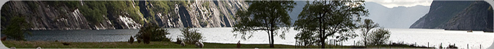
All very nice but it was time to do some proper walking. We headed inland from Stavanger, along route 45 and then by smaller roads through Haugden and Fidgeland, then smaller roads still until we dropped down the 29 bends into Lysebotn at the head of Lysefjorden. This was an impressive spot with huge granite cliffs plunging straight into the fjord, (see banner) the campsite however was less impressive, overpriced and under facilitated. We should have wild camped on the tops like a few other campers had. Next day we drove back up the 29 bends, parked and took the 2 hour walk across the ice scraped hillside of Kjerag. Above left picture Kjerag, to its famous jammed boulder, middle picture. Yes that's me, for some reason Suzy refuse to reciprocate. After returning to the camper we headed back and stayed the night at an excellent site near Haugen, cheap(er), clean and with free showers.
The other well publicised hike is to Preikestolen (Pulpit Rock, right picture and gallery). We stayed at Preikestolen camping which, though quite expensive had excellent facilities and free internet. The track to the Preikestolen may be well used but it's still a beautiful walk of about 4 hours return with some impressive positions above Lysefjord. And the Pulpit Rock? Stunning, despite the Saturday afternoon crowds.


Back on the road again, this time we were heading towards the Folgafonna glacier system, the southern part of which is Norway's third largest glacier. The weather was perfect for the drive and we followed route 13 across the ferry at Hjelmelandsvagen then along the side of Sandesfjorden to Sand where the road turned inland eventually passing alongside the stunningly beautiful Suldalsvatn lake, through tunnels and over passes, eventually descending past enormous waterfalls to the small town of Odda. Poor Odda gets a terrible review in the travel guides because of its steelworks and zinc processing plants, suggesting that the air was barely fit to breathe. We found this totally unjustified, the steel plant in the centre of town is long closed and the site may become a park. The plants on the outskirts seemed essentially pollution free. The campsite, though acceptable could have been a lot better however, there was rather limited amenities for the size of site and the office only seemed to be open for 1 hour a day. Still, it was a nice position on the shores of Lake Sandvin and was only a short drive to Buer where it was possible to walk up to the snout of the Buerbreen glacier. See picture 1, 2, .
Above, L-R, Buerbreen glacier, Marsh Violet Viola palustris, Kinsarvik falls, Dwarf Cornel Cornus suecica which was common in Norway but is rare in the UK and Purple Saxifrage Saxifraga oppositifolia.
The area is famous for its torrents and waterfalls, Lofthus claims to have one of the highest, much disputed, but Kinsarvik, a few km further up the fjord must contain some of the most spectacular. There was a series of four and they were huge.
The Hardangervidda continued to draw us but eventually we broke free and headed again for pastures new. The road from Eidfjord to Geilo is amongst the highest in Norway and is classified as a National Scenic route. It reaches a height of over 1200m which means that for half the year it is covered in snow. Well, it probably would have been scenic had we emerged from the cloud layer, we did however manage to glimpse lots of snow and frozen lakes though. Some 10km past the ski resort of Geilo we left the main Route 7 to follow the smaller Route 50 over some wonderfully scenic uplands past more lakes frozen and unfrozen, snow and waterfalls as far as the eye could see until eventually, almost disappointingly the road lost height as it dropped down through tunnels and zigzags to the town of Aurland.
Aurland is famous for, amongst other things, being at one end of the longest road tunnel in the world, on our last trip 6 years ago we drove through its 25km which was fairly mind numbing, the second thing is that it marks the end of a classic 4 day walk from Finse. We discovered that it was possible to take public transport to Vassbygdi and follow the last day's section down Aurlandsdal to to Østerbø, typically taking about 7 hours to cover the 21km. The bus only ran at the weekends so despite the heavy drizzle, we went for it. This turned out to be a superb walk of gorges, lakes and cascades, covering about 1300m of descent and 300m of ascent. As the day wore on, the sun broke through and by the time we had returned to our campervan at Østerbø we were in T shirts. See the gallery for pictures.


Next day, spurning the road tunnel we took the old road over the top which was quite beautiful. At the north end of the tunnel is Lærdals which is nothing like as pretty as Aurland, and from here we headed to the ferry across the Ardalfjorden to the small town of Sogndalsfjora where we turned right onto the 604, a dead-end road up the Jostedalen valley. The valley follows the eastern edge of the huge Jostedalsbreen glacier , the largest glacier in Europe, and gave access to the various tongues of ice that hung over it. At the village of Gjerde is Jostedal Camping which turned out to be one of the least expensive and best equipped of any of the campsites that we visited in Norway.
So, a new valley and lots to go at. The Nigardsbreen glacier is by far the most popular, accessed by a small toll road which led to a large car park by a lake. The walk to the glacier snout was pleasant and easy and by arriving before 10.00 am we avoided the coach loads of visitors. Left, Suzy on the bridge over the glacial river, Nigardsbreen glacier behind. There were other glaciers less well visited and we walked to the Bergsetbreen glacier (easy) and the Tuftebreen glacier (steep) where we saw no-one at all. Suzy did spot a Coral-root Orchid though, a rare and insignificant little thing which seemed to make her day. Glaciers? Oh yes I think that I remember them. The little road up the valley branches after a few km and by taking the left branch and ignoring the sign warning of sub-standard road surface one eventually ends up at a frozen lake (reservoir actually) where there were fabulous views down the to the distant Jostalbreen glacier, see Gallery. Middle picture, by the car park, I think it's moving! and right, Suzy and the Tuftebreen glacier.
After 3 days of hot weather in the Jostedalen valley, we woke up to sullen grey skies and a hint of drizzle. What! Perhaps a sign to move on. We drove back down the valley to Gaupne and turned left onto Route 55 which takes in Norway's highest road at over 1400m but as on our crossing of the Hardangervidda, the weather was, well, mixed and views across the icefields were obscured by cloud.
Mountains became more rounded as we dropped down to the small town of Lom, and undecided we stayed there overnight a Lom Camping. The weather remained overcast and we "ummed and arred" about going to the nearby Rondane national park but the brochures from the tourist office didn't sell it to us, too much easy moorland and Langlauf track and the Rother Guide only described high mountain routes which were still snowbound from the winter.
A snap decision was made, we'd abandon the rolling slopes of the Rondane, beautiful though they probably were, and head back into fjord country. Next morning, stocked up with fuel, food and fresh water we drove into Lom and turned west onto Route 15. This climbed progressively over the next 50km, the scenery gradually becoming wilder as did the weather. At Grotli, at about 900m all hell let loose and we were subjected to a severe battering by horizontal sleet. To the west, our route, a huge white cloud had settled over the scenery. After passing the Breidalsvatn lake we turned right, signposted Geiranger and were soon dropping down to this popular tourist spot where 6 years ago we had enjoyed wonderfully sunny weather. The rain continued to drum on the camper roof and after a lunch break in a picnic spot by the fjord we continued out of the valley, up the zigzags and down to Eidsdal where we took the ferry to Linge. We continued along Route 63 for a few km until we found a campsite where we hunkered down for the rest of the day and watched our field gradually become a lake.


Next morning, the rain still poured down unabated as we headed towards the Trollstigen pass, about 850m. Soon, the rain turned to sleet and then the sleet turned to snow and then the road became white over, see picture 19. Sliding around a bit we eventually we met a snow plough coming the other way and were later to learn that the pass was closed shortly after we crossed it. We were now entering the Romsdal valley which was streaming with spectacular waterfalls and where we had also stayed 6 years ago. After a bit of shopping in Andalsnes we checked in at Andalsnes camping, hooked up, turned on the fan heater, put the kettle on and dug out a good book or two.
Trollstigen Pass
Bog Rosemary Andromeda polifolia
Romsdal valley with Andalsnes camping and our campervan if you know where to look.
The famous stave church at nearby Rødven,
Suzy on Litlefjellet looking towards the Romsdalhorn 1550m,
Snow clearing from the hills in the evening, from the campsite.
Over the next four days the weather gradually improved and the snow level which had been down at 500m gradually crept up to more normality. We completed 3 excellent walks while we were in the Romsdal area. We walked from the campsite up the valley shown in picture 21 until, after crossing a serious bog we decided that we had had enough and returned though the trip took over 5 hours. Day 2 we walked again from the campsite up onto a small peak called Nesaksla overlooking Andalsnes which gave some excellent views. Day 3 we went touring to look at the stave church at Rødven and pottered along the coastline, Suzy clutching her botanical field guide. Day 4 was hot and sunny and we drove round into the beautiful Benjedalen valley on the northeast side of the Romsdalhorn, and climbed up onto the Litlefjellet ridge which gave some wonderful views of the Romsdalhorn, Troll Wall and Andalsnes.


Only 2 weeks left and so we decided to head towards Sweden for the last stage of our holiday, and perhaps spend a couple of days exploring Gothenberg on the way home. Next morning we packed up, serviced the campervan, paid the campsite, stocked up with food and headed out on the E136 out of Andalsnes towards Dombas. The weather was fine and it was a spectacular drive, redolent with waterfalls, cascades and rocky gorges that the road zigzagged in and out of. At Dombas, the road leveled and we headed up the E6 over some high country, over the Dovrefjell National Park to the town of Oppdal and then Støren. By this time however the weather was changing and cloud and light rain followed us for the rest of the day.
At Støren we turned east onto Route 30 heading for Røros. It had been a long day, and on the grey rainy afternoon Røros town did not inspire, despite a fairly upbeat review in the Lonely Planet guide. Røros was an old mining town and though the mines have long closed the old miners houses still remain and there are lots of museums and mines to visit. A campsite was difficult to locate but eventually we located one on Route 30 towards Trondheim, a km or so out of town. It was a bit of a depressing mess of a site and as the rain increased and the long evening drew on we decided that the best option was to draw the blinds, turn up the fan heater and crack open the last box of illegal wine. Next morning we explored the town but in the grey and drizzly light everything looked a bit depressing despite it being a UNESCO heritage site and we decided to head into Sweden.
Much of Sweden is covered in trees, and much as we like trees there was a certain monotony to driving hundreds of km and seeing little else despite the pleasantly hilly terrain. Many of the publicised "walking" areas turned out to be winter skiing areas without snow and after Norway they didn't really attract us. We pressed on and by evening we were in the town of Sveg, famous for the largest wooden statue of a bear in the world (13m) meant to remind one that this is bear country. The town was pleasant, there was a vintage American car rally about to start next day and the campsite was pleasantly situated by the river.
Next day we continued down the E45 towards Lake Siljan, created in the Devonian period when a meteorite impacted. We stopped off at Orsa and visited the famous bear park there. It was quite good I suppose and though the animals have loads of room and woodland to move around in it was still a zoo. We saw Brown Bears, Polar Bears and Siberian Tigers amongst other creatures. The park was very popular and family oriented.
After Orsa we passed through the town of Mora and then took to the west side of the lake towards Leksand. A few km short of the town was the very pleasant Vastvikbadet camping which was like a breath of fresh air, and we stayed there for 3 nights. Across the lake was the much larger Leksand Strand Stugby and Camping which was more like a holiday camp. (Stugby = Huts) Leksand was a pleasant town and it was possible to combine a visit to the fine 13C church, the old houses of Hembygsgården and an easy 4km walking circuit by the lake.
Picture 1. Evening light at Vastvikbadet campsite across lake Siljan.
Picture 2. Evening light by Lake Vanern.


Gothenburg (or Gotebörg).
For Gothenburg we stayed at Kronocamping which was within easy reach of the centre of Gothenburg by public transport. They were also able to sell us a 2 day Gothenburg Go-pass which allowed us free or reduced cost on public transport and many of the attractions there.
The 753 bus stopped almost outside the campsite gates and within 20 minutes we were in the centre of Gothenburg. After wandering about a bit and getting oriented Gothenberg's canals and harbour we opted to visit the Maritima museum, an intriguingly linked set of wartime boats, including a destroyer, a submarine and a lightship. All very interesting, probably the submarine (picture 2) was the most fascinating and it was hard to see how 37 men could have lived inside such a cramped vessel. After dinner in the park we visited the Botanical gardens, the city museum and finished up with a free trip on a tourist boat around the waterways.
Day 2, same bus same city, this time we took a boat to the a nearby fortress island of Alvsborgs Fastning where those who could speak Swedish were entertained by guides dressed up as 18th century soldiers (see picture 4) while the rest of us (all four) wandered off on our own and as there were plenty of notice boards in English we easily got a grasp of the fortress' history. On return we took a trip up the red and white tower in picture 3, locally known as the lipstick. From the top of here there were some pretty amazing views across the city.
And last but not least, we visited the Konstmuseum art gallery, extra famous for the huge statue of a naked athlete in the square outside. The statue has a controversial history for when it was first commissioned people were outraged by the size of its penis. It was consequently taken down and the offending member trimmed. Consensus is however that they overdid the trimming and that he has now become somewhat under endowed.


Next day we travelled south again towards the Malmö and the bridge which links Sweden to Denmark, but before that, took a sharp right at the town of Båstad and travelled onto the Bjärehalvön peninsula and the town of Torekov. It was by now the 3rd of July and we were into high season so we feared that this little gem of a town and its campsite would be heaving. Well, full-ish but they managed to find us a pleasant pitch under the trees and close to the sea at First Camp Torekov, so nice that we stayed there 2 nights.
The surrounding area was a nature reserve and there were numerous iron-age burial sites around the coast. We walked for several km along the coastal path which was quite rough in places but the temperature was in the low '30s and eventually, probably due to dehydration we turned back to shady comfort of the campervan and drank lots of chilled beers. That night we walked into Terakov and booked a boat trip to the nearby island of Hallands Väderö and took pictures of the sun setting over the island, picture 1. Hallands Väderö is popular for several reasons,. it has some fine sandy beaches unlike Torekov, it's a nature reserve and there are idyllic looking holiday cottages for hire. It's a smashing little island though, it would also be worth a visit when the south westerlies are blasting in off the Kattegatt.
Denmark. So over the Oresund bridge at Malmö, pay your £32 in whatever currency you fancy and you're in Denmark. After Copenhagen we trended south down the E47/E55, through Køge and another 56 km to junction 41 where we left the motorway for Møns Klint. Klint means cliff, and these were probably the biggest cliffs in Denmark, topping out at 143m. Craggy climbing cliffs? Sadly no, crumbly chalk cliffs but definite cliffs all the same. We stayed at the pleasant Camping Møns Klint some 20 minutes easy walk to the cliffs through pleasant woods and meadows full of orchids, more South Downs than Scandinavia. There were several wooden stairways to take one down to the sea, 490 steps on ours. Picture 2, Møns Klint.
Hamburg, Bremen and then, tired and fed up with driving on busy roads with road works we looked for a campsite but having no information about campsites in Germany we just left the Autobahn and headed for a lakeside town. Yes! We just chanced on a idyllic little site near Bad-Swischenahn. Small, quiet and clean, an island of sanity in a sea of hysteria.
Next day we headed for Amsterdam where the sea of hysteria reasserted itself. The city campsite at Camping Vliegenbos was packed and we ended up parked on a patch of gravel at the side of the entrance drive. We had intended to visit the city the following day, but the thought of spending a hot afternoon doing nothing in a crowded campsite spurred is into jumping onto a local bus to take us into the centre of town, then getting a tram to the Van Goch museum. Like the city, the museum was very busy, full of tourists (like us but younger), students and back packers (minus back packs). The museum was excellent, lots of Van Goch paintings and that of other impressionist artists. By the time we had fought our way back across the city, I think that we were both ready for home.
Picture left, A windmill amongst many windmills.
Flowers of Norway and Sweden 2010
Costs for period 14/5/10 to 13/7/10 for Renault Master van conversion campervan with two people.
- Camping: £1226
- Deisel fuel: £680
- Hull - Rotterdam Ferry: £294
- Fredrickshaven - Gothenburg Ferry: £150
- Rodbyhavn - Puttgarden Ferry: £57
- Fjord Ferries: £36
- Road and Bridge Tolls: £100
- Gothenburg 48h pass for 2: £67
- Total: £2443
Distance travelled: 4500 miles
Average fuel consumption: 33.5 mpg.
Food and booze costs not included.
Eating out in Norway is very expensive, slightly less so in Sweden. Food in the shops was typically UK price X 1.5, cheaper in Sweden. Wine and spirits are very expensive in Scandinavia and can only be bought at special governmant controlled outlets. Beer is available in supermarkets. Diesel prices in Scandinavia were not that dissimilar to UK, Norway a bit more expensive out of town. Headlights on dipped, watch your speed, usually 80kph (50mph) out of town, 50kph (30mph) in town unless otherwise indicated. Motorways are faster.
chris.jackson@zen.co.uk